Lowry Pueblo
Archaeological site in Colorado, United States
United States historic place
Lowry Ruin | |
U.S. National Historic Landmark | |
 Lowry Pueblo | |
37°35′4.31″N 108°55′10.73″W / 37.5845306°N 108.9196472°W / 37.5845306; -108.9196472 | |
| Area | 3 acres (1.2 ha) |
|---|---|
| NRHP reference No. | 66000253 |
| Significant dates | |
| Added to NRHP | October 15, 1966[1] |
| Designated NHL | July 19, 1964[2] |
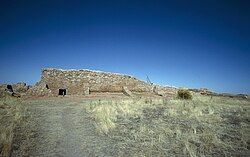
The Lowry Pueblo is an Ancestral Puebloan archaeological site located in Canyons of the Ancients National Monument near Pleasant View, Colorado, United States. The pueblo was constructed around 1060 AD atop abandoned pithouses from an earlier period of occupation. It was occupied by 40 to 100 people at a time for 165 years.[3] The site is one of the northernmost to be associated with the Puebloan cultures.[4] The site was declared a National Historic Landmark in 1964.[2][4]
Description
Lowry Pueblo is located about 45 miles (72 km) northwest of Cortez, Colorado, and about 100 miles (160 km) north of Chaco Canyon, one of the major centers of Ancestral Puebloan culture. The pueblo was named for the early area homesteader George Lowry. It is believed to have begun as a relative small community with just a few rooms, but is unusual for the presence of a great kiva, suggesting it served as a communal center for a scattered population before the settlement around it got larger.[4] The inhabitants were farmers who also hunted small game, made elaborately decorated pottery, and wove cotton obtained by trade. Its last occupation occurred in the early 13th century.
Lowry Pueblo was first excavated during summer field seasons from 1930 to 1934 by Paul Sidney Martin of the Field Museum of Natural History in Chicago.[5] In 1965, the Bureau of Land Management (BLM), which owned the property, undertook a two-year project with the University of Colorado to stabilize the ruins, which had become partially buried. It was incorporated as part of the Canyons of the Ancients National Monument in 2000.
-
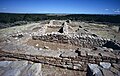 Lowry Pueblo
 -
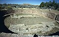 Great Kiva in Lowry Pueblo


See also
- Ancestral Puebloans
- Anasazi Heritage Center
- Hovenweep National Monument
- List of National Historic Landmarks in Colorado
References
- ^ "National Register Information System". National Register of Historic Places. National Park Service. January 23, 2007.
- ^ a b "Lowry Ruin". National Historic Landmark summary listing. National Park Service. Archived from the original on January 4, 2008. Retrieved October 16, 2007.
- ^ "Bureau of Land Management". Archived from the original on July 16, 2010. Retrieved April 16, 2012.
- ^ a b c Albert H. Schroeder (September 24, 1962) National Survey of Historic Sites and Buildings: Lowry Pueblo (includes maps and diagrams of site), National Park Service and Accompanying 2 photos, from the Field expedition.
- ^ "Field Museum News". September 1930. Retrieved May 6, 2020.
https://www.blm.gov/programs/national-conservation-lands/colorado/canyons-of-the-ancients
External links
Wikimedia Commons has media related to Lowry Pueblo Ruin.
- [1]
- Lowry Ruin at Field Museum of Natural History website
- v
- t
- e

| 43 State Parks |
|
|---|---|
| 1 State Forest | |
| 307 State Wildlife Areas | |
| 96 State Natural Areas |
|
| 26 Scenic and Historic Byways |
|
| 28 National Recreation Trails |
|
|---|---|
| 6 Regional Trails |

| |
|---|---|
| Topics | |
| Lists by state |
|
| Lists by insular areas | |
| Lists by associated state | |
| Other areas | |
| Related | |
| |


