Grand Mesa National Scenic Byway
Colorado Scenic and Historic Byway
Grand Mesa National Scenic Byway | |
|---|---|
 | |
| Route information | |
| Maintained by CDOT | |
| Length | 63 mi[1][2] (101 km) |
| Existed | 1991–present |
| Major junctions | |
| Southeast end |  SH 65 Cedaredge SH 65 Cedaredge |
| Northwest end |  SH 65 / I-70 Exit 49 SH 65 / I-70 Exit 49 |
| Location | |
| Country | United States |
| State | Colorado |
| Counties | Delta and Mesa counties |
| Highway system | |
| |


The Grand Mesa National Scenic Byway is a 63-mile (101 km) National Scenic Byway, National Forest Scenic Byway, and Colorado Scenic and Historic Byway located in Delta and Mesa counties, Colorado, USA. The byway traverses Grand Mesa, the most extensive flat-topped mountain on Earth, and reaches an elevation of 10,849 feet (3,307 m). The byway comprises Colorado State Highway 65 from Cedaredge to Interstate 70 Exit 49 and Forest Service Road 100 to the Land's End Observatory.
Route
Gallery
-

-
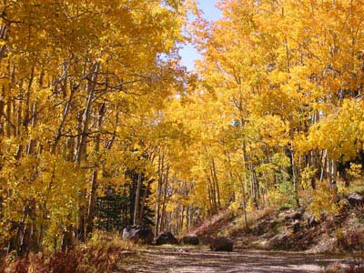 Aspen in autumn color change on the Grand Mesa National Scenic Byway
 -


See also
 History portal
 U.S. Roads portal
 Colorado portal
Notes
References
- ^ "Grand Mesa". Colorado Department of Transportation. 2021. Retrieved March 28, 2022.
- ^ "Grand Mesa Scenic and Historic Byway". America's Scenic Byways. Retrieved April 7, 2022.
External links
Colorado at Wikipedia's sister projects
 Media from Commons
 News from Wikinews
 Quotations from Wikiquote
 Travel information from Wikivoyage
KML file (edit • help)
Template:Attached KML/Grand Mesa Scenic and Historic Byway
KML is not from Wikidata
- America's Byways
- America's Scenic Byways: Colorado
- Colorado Department of Transportation
- Colorado Scenic & Historic Byways Commission
- Colorado Scenic & Historic Byways
- Colorado Travel Map
- Colorado Scenic & Historic Byways Commission
- Colorado Tourism Office
- History Colorado
- National Forest Scenic Byways
- v
- t
- e
Denver (capital)
- Bibliography
- Index
- Outline
- Climate change
- Colleges
- Coloradans
- Elections
- Federal lands
- Geography
- Government
- Historic places
- History
- Images
- Indian reservations
- Law
- Lists
- Military
- Mountains
- Municipalities
- Museums
- National Forests
- National Parks
- Paleontology
- Prehistoric sites
- Prehistory
- Protected areas
- Railroads
- Rivers
- Slavery
- Statistical areas
- Symbols
- Timeline
- Tourist attractions
- Towns
- Trails
- Transportation
- Wildernesses
- Alamosa
- Arvada
- Aspen
- Aurora
- Black Hawk
- Boulder
- Brighton
- Broomfield
- Brush
- Burlington
- Cañon City
- Castle Pines
- Centennial
- Central City
- Cherry Hills Village
- Colorado Springs
- Commerce City
- Cortez
- Craig
- Cripple Creek
- Dacono
- Delta
- Denver
- Durango
- Edgewater
- Englewood
- Evans
- Federal Heights
- Florence
- Fort Collins
- Fort Lupton
- Fort Morgan
- Fountain
- Fruita
- Glendale
- Glenwood Springs
- Golden
- Grand Junction
- Greeley
- Greenwood Village
- Gunnison
- Holyoke
- Idaho Springs
- La Junta
- Lafayette
- Lakewood
- Lamar
- Las Animas
- Leadville
- Littleton
- Lone Tree
- Longmont
- Louisville
- Loveland
- Manitou Springs
- Monte Vista
- Montrose
- Northglenn
- Ouray
- Pueblo
- Rifle
- Rocky Ford
- Salida
- Sheridan
- Steamboat Springs
- Sterling
- Thornton
- Trinidad
- Victor
- Walsenburg
- Westminster
- Wheat Ridge
- Woodland Park
- Wray
- Yuma
- Adams
- Alamosa
- Arapahoe
- Archuleta
- Baca
- Bent
- Boulder
- Broomfield
- Chaffee
- Cheyenne
- Clear Creek
- Conejos
- Costilla
- Crowley
- Custer
- Delta
- Denver
- Dolores
- Douglas
- Eagle
- El Paso
- Elbert
- Fremont
- Garfield
- Gilpin
- Grand
- Gunnison
- Hinsdale
- Huerfano
- Jackson
- Jefferson
- Kiowa
- Kit Carson
- La Plata
- Lake
- Larimer
- Las Animas
- Lincoln
- Logan
- Mesa
- Mineral
- Moffat
- Montezuma
- Montrose
- Morgan
- Otero
- Ouray
- Park
- Phillips
- Pitkin
- Prowers
- Pueblo
- Rio Blanco
- Rio Grande
- Routt
- Saguache
- San Juan
- San Miguel
- Sedgwick
- Summit
- Teller
- Washington
- Weld
- Yuma
- Central Colorado
- Eastern Plains
- Colorado Mineral Belt
- Colorado Piedmont
- Colorado Plateau
- Colorado Western Slope
- Denver Metropolitan Area
- Four Corners Region
- Front Range Urban Corridor
- High Plains
- North Central Colorado Urban Area
- Northwestern Colorado
- San Luis Valley
- South-Central Colorado
- South Central Colorado Urban Area
- Southern Rocky Mountains
- Southwest Colorado
 Colorado portal
39°01′38″N 108°01′55″W / 39.0273°N 108.0320°W / 39.0273; -108.0320 (Grand Mesa Summit, Colorado, USA)
 | This Colorado road-related article is a stub. You can help Wikipedia by expanding it. |
- v
- t
- e


