Grade I listed buildings in South Oxfordshire
Map all coordinates using OpenStreetMap
Download coordinates as:
- KML
- GPX (all coordinates)
- GPX (primary coordinates)
- GPX (secondary coordinates)
There are over 9,000 Grade I listed buildings in England. This page is a list of these buildings in the district of South Oxfordshire in Oxfordshire.
List of buildings
| Name | Location | Type | Completed [note 1] | Date designated | Grid ref.[note 2] Geo-coordinates | Entry number [note 3] | Image |
|---|---|---|---|---|---|---|---|
| Beckley Park | Beckley | House | c.1540 | 18 July 1963 | SP5772211975 51°48′12″N 1°09′51″W / 51.803446°N 1.164273°W / 51.803446; -1.164273 (Beckley Park) | 1180781 |  More images |
| Church of the Assumption of the Blessed Virgin Mary | Beckley | Church | 14th century | 18 July 1963 | SP5622711262 51°47′50″N 1°11′10″W / 51.797188°N 1.186068°W / 51.797188; -1.186068 (Church of the Assumption of the Blessed Virgin Mary) | 1047650 | 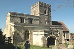 More images |
| Church of St Bartholomew | Brightwell Baldwin | Church | 13th century | 18 July 1963 | SU6532095002 51°39′00″N 1°03′26″W / 51.650026°N 1.057275°W / 51.650026; -1.057275 (Church of St Bartholomew) | 1059763 |  More images |
| Small's House | Mackney, Brightwell-cum-Sotwell | House | c.1580 | 9 April 1952 | SU5790989973 51°36′20″N 1°09′55″W / 51.605625°N 1.165209°W / 51.605625; -1.165209 (Small's House) | 1368884 | 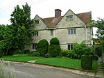 More images |
| Church of St Mary | Chalgrove | Church | Early 13th century | 18 July 1963 | SU6371696549 51°39′51″N 1°04′49″W / 51.664118°N 1.080174°W / 51.664118; -1.080174 (Church of St Mary) | 1284879 | 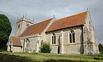 More images |
| The Manor | Chalgrove | Hall House | Early 15th century | 18 July 1963 | SU6306197027 51°40′07″N 1°05′22″W / 51.668489°N 1.089557°W / 51.668489; -1.089557 (The Manor) | 1368856 |  Upload Photo |
| Church of St Peter and St Paul | Checkendon | Church | 12th century | 9 February 1959 | SU6632283040 51°32′33″N 1°02′42″W / 51.54237°N 1.045052°W / 51.54237; -1.045052 (Church of St Peter and St Paul) | 1180822 |  More images |
| Church of St Andrew | Chinnor | Church | Early 13th century | 18 July 1963 | SP7567900889 51°42′06″N 0°54′23″W / 51.701651°N 0.906301°W / 51.701651; -0.906301 (Church of St Andrew) | 1368881 |  More images |
| Church of St Mary | Cholsey | Church | 11th century | 14 June 1963 | SU5837487007 51°34′44″N 1°09′32″W / 51.578911°N 1.158988°W / 51.578911; -1.158988 (Church of St Mary) | 1059283 |  More images |
| Church of St Mary Magdalene | Crowmarsh Gifford | Church | 12th century | 9 February 1959 | SU6146689314 51°35′58″N 1°06′50″W / 51.599324°N 1.113969°W / 51.599324; -1.113969 (Church of St Mary Magdalene) | 1059582 |  More images |
| Church of All Saints | Cuddesdon | Church | Mid–late 12th century | 18 July 1963 | SP6007803045 51°43′23″N 1°07′54″W / 51.722917°N 1.13165°W / 51.722917; -1.13165 (Church of All Saints) | 1047709 |  More images |
| Abbey Church of St Peter and St Paul | Dorchester on Thames | Abbey | 1140–1536 | 18 July 1963 | SU5792794196 51°38′37″N 1°09′51″W / 51.643589°N 1.164252°W / 51.643589; -1.164252 (Abbey Church of St Peter and St Paul) | 1193595 | 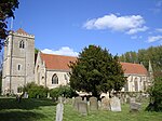 More images |
| Churchyard cross approximately 6 metres south of Dorchester Abbey | Dorchester on Thames | Cross | 14th/15th century | 18 July 1963 | SU5789094188 51°38′37″N 1°09′53″W / 51.643521°N 1.164788°W / 51.643521; -1.164788 (Churchyard cross approximately 6 metres south of Dorchester Abbey) | 1047865 |  |
| Church of St Andrew | East Hagbourne | Church | 12th century | 14 June 1963 | SU5254988196 51°35′25″N 1°14′34″W / 51.590173°N 1.242864°W / 51.590173; -1.242864 (Church of St Andrew) | 1047927 |  More images |
| Church of St Mary | Ewelme | Church | c.1432 | 18 July 1963 | SU6466091405 51°37′04″N 1°04′03″W / 51.617765°N 1.067476°W / 51.617765; -1.067476 (Church of St Mary) | 1059360 |  More images |
| Ewelme Church of England Primary School | Ewelme | School | c.1450 | 18 July 1963 | SU6459891360 51°37′03″N 1°04′06″W / 51.617368°N 1.06838°W / 51.617368; -1.06838 (Ewelme Church of England Primary School) | 1369062 |  More images |
| Gods Place, and lobby to Church of St Mary | Ewelme | Almshouse | c.1437 | 18 July 1963 | SU6463691394 51°37′04″N 1°04′04″W / 51.617669°N 1.067825°W / 51.617669; -1.067825 (Gods Place, and lobby to Church of St Mary) | 1369023 | 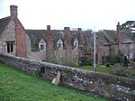 More images |
| School House and archway | Ewelme | School house | Mid-15th century | 18 July 1963 | SU6460491379 51°37′03″N 1°04′06″W / 51.617538°N 1.06829°W / 51.617538; -1.06829 (School House and archway) | 1059349 |
|
| Church of St Thomas of Canterbury | Goring on Thames | Church | 12th century | 9 February 1959 | SU5976480711 51°31′20″N 1°08′24″W / 51.522163°N 1.139998°W / 51.522163; -1.139998 (Church of St Thomas of Canterbury) | 1194201 |  More images |
| Alnutts Hospital and attached forecourt walls and gate | Goring Heath | Almshouses | c. 1724 | 24 October 1951 | SU6569779447 51°30′37″N 1°03′17″W / 51.510141°N 1.054732°W / 51.510141; -1.054732 (Alnutts Hospital and attached forecourt walls and gate) | 1194275 |  More images |
| Church of St Peter | Great Haseley | Church | c. 1200 | 18 July 1963 | SP6443101695 51°42′37″N 1°04′08″W / 51.710299°N 1.068889°W / 51.710299; -1.068889 (Church of St Peter) | 1047529 |  More images |
| Tithe barn at Church Farm and attached wall at the stables | Great Haseley | Tithe barn | c. 1400 | 18 July 1963 | SP6444501765 51°42′39″N 1°04′07″W / 51.710926°N 1.068674°W / 51.710926; -1.068674 (Tithe barn at Church Farm and attached wall at the stables) | 1047532 | Upload Photo |
| Church of St Mary | Great Milton | Church | 11th century | 18 July 1963 | SP6279902422 51°43′01″N 1°05′33″W / 51.717019°N 1.092375°W / 51.717019; -1.092375 (Church of St Mary) | 1369258 |  More images |
| Chantry House | Henley-on-Thames | Chantry college | c. 1400 | 25 January 1951 | SU7629382693 51°32′17″N 0°54′05″W / 51.537993°N 0.901375°W / 51.537993; -0.901375 (Chantry House) | 1047033 |  More images |
| Henley Bridge | Henley-on-Thames | Bridge | 1786 | 25 January 1951 | SU7634282644 51°32′15″N 0°54′02″W / 51.537546°N 0.900679°W / 51.537546; -0.900679 (Henley Bridge) | 1369131 |  More images |
| Church of St Bartholomew | Holton | Church | Late 12th century | 18 July 1963 | SP6051806391 51°45′11″N 1°07′29″W / 51.752951°N 1.1247°W / 51.752951; -1.1247 (Church of St Bartholomew) | 1047596 |  More images |
| Church Farm, barn approximately 30 metres ESE of farmhouse (not included) | Lewknor | House | Mid-/late 14th century | 19 November 1976 | SU7150697658 51°40′23″N 0°58′02″W / 51.673152°N 0.967336°W / 51.673152; -0.967336 (Church Farm, barn approximately 30 metres ESE of farmhouse (not included)) | 1368861 | Upload Photo |
| Church of St Margaret | Lewknor | Church | Late 12th century | 18 July 1963 | SU7157297650 51°40′23″N 0°57′59″W / 51.673071°N 0.966383°W / 51.673071; -0.966383 (Church of St Margaret) | 1182190 |  More images |
| Haseley Court | Little Haseley | Country house | 14th century | 18 July 1963 | SP6449300596 51°42′01″N 1°04′06″W / 51.700412°N 1.068195°W / 51.700412; -1.068195 (Haseley Court) | 1047539 |  More images |
| Church of St Mary | Long Wittenham | Church | c. 1120 | 14 June 1963 | SU5484894043 51°38′33″N 1°12′32″W / 51.642521°N 1.208768°W / 51.642521; -1.208768 (Church of St Mary) | 1368798 |  More images |
| Church of St Margaret and Bardolf Aisle | Mapledurham | Church | 13th century | 9 February 1959 | SU6700576676 51°29′06″N 1°02′11″W / 51.485076°N 1.036412°W / 51.485076; -1.036412 (Church of St Margaret and Bardolf Aisle) | 1059519 |  More images |
| Mapledurham House | Mapledurham | Country house | c. 1585 | 24 October 1951 | SU6706776655 51°29′06″N 1°02′08″W / 51.48488°N 1.035523°W / 51.48488; -1.035523 (Mapledurham House) | 1368944 | 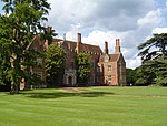 More images |
| Church of St Giles | Newington | Church | 12th century | 18 July 1963 | SU6087896527 51°39′51″N 1°07′16″W / 51.664234°N 1.121205°W / 51.664234; -1.121205 (Church of St Giles) | 1193229 |  More images |
| Church of All Saints | North Moreton | Church | Early 13th century | 14 June 1963 | SU5620689569 51°36′08″N 1°11′24″W / 51.602165°N 1.189862°W / 51.602165; -1.189862 (Church of All Saints) | 1181258 |  More images |
| Church of St Mary | North Stoke | Church | 13th century | 9 February 1959 | SU6089786210 51°34′17″N 1°07′22″W / 51.57148°N 1.12272°W / 51.57148; -1.12272 (Church of St Mary) | 1059577 |  More images |
| Carfax Conduit | Nuneham Courtenay | Conduit | 1617 | 18 July 1963 | SU5372797671 51°40′31″N 1°13′28″W / 51.675247°N 1.22441°W / 51.675247; -1.22441 (Carfax Conduit) | 1193569 |  More images |
| Rycote Chapel | Rycote | Church | 1449 | 18 July 1963 | SP6669904651 51°44′12″N 1°02′08″W / 51.736608°N 1.035504°W / 51.736608; -1.035504 (Rycote Chapel) | 1047514 |  More images |
| Greys Court | Rotherfield Greys | House | 14th century | 24 October 1951 | SU7248283417 51°32′42″N 0°57′22″W / 51.545003°N 0.956164°W / 51.545003; -0.956164 (Greys Court) | 1181202 |  More images |
| Greys Court, Dower House | Rotherfield Greys | Dower house | 16th century | 24 October 1951 | SU7254483383 51°32′41″N 0°57′19″W / 51.544689°N 0.955277°W / 51.544689; -0.955277 (Greys Court, Dower House) | 1047391 |  More images |
| Greys Court, Great Tower, attached ruined tower and walls approximately 60 metres east | Rotherfield Greys | Fortified house | 14th century | 24 October 1951 | SU7254183441 51°32′43″N 0°57′19″W / 51.545211°N 0.955308°W / 51.545211; -0.955308 (Greys Court, Great Tower, attached ruined tower and walls approximately 60 metres east) | 1181246 |  More images |
| Greys Court, the Keep | Rotherfield Greys | Keep | 14th century | 24 October 1951 | SU7244983374 51°32′41″N 0°57′24″W / 51.544621°N 0.956649°W / 51.544621; -0.956649 (Greys Court, the Keep) | 1369333 | 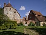 More images |
| Greys Court, Well House | Rotherfield Greys | Timber-framed house | 16th century | 24 October 1951 | SU7246783373 51°32′41″N 0°57′23″W / 51.544609°N 0.956389°W / 51.544609; -0.956389 (Greys Court, Well House) | 1369334 | More images |
| Shirburn Castle | Shirburn | Castle | 1377 | 18 July 1963 | SU6966095976 51°39′30″N 0°59′40″W / 51.658262°N 0.994362°W / 51.658262; -0.994362 (Shirburn Castle) | 1368852 |  More images |
| Shotover Park | Shotover | Country house | c.1715–20 | 18 July 1963 | SP5841506714 51°45′22″N 1°09′18″W / 51.756078°N 1.155108°W / 51.756078; -1.155108 (Shotover Park) | 1284986 | 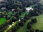 More images |
| Church of St John the Baptist | Stanton St. John | Church | c. 1200 | 18 July 1963 | SP5775009372 51°46′48″N 1°09′51″W / 51.780042°N 1.1643°W / 51.780042; -1.1643 (Church of St John the Baptist) | 1182305 |  More images |
| Stonor House and attached walls and buildings | Stonor | Country house | 13th century | 24 October 1951 | SU7425289228 51°35′49″N 0°55′46″W / 51.597013°N 0.929418°W / 51.597013; -0.929418 (Stonor House and attached walls and buildings) | 1059444 | 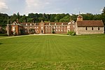 More images |
| Chapel approximately 10 metres south of the Prebendal | Thame | Chapel | c. 1250 | 24 April 1951 | SP7021906359 51°45′06″N 0°59′03″W / 51.751533°N 0.984194°W / 51.751533; -0.984194 (Chapel approximately 10 metres south of the Prebendal) | 1180882 |  |
| Church of St Mary | Thame | Church | Early 13th century | 24 April 1951 | SP7038506318 51°45′04″N 0°58′54″W / 51.751144°N 0.981798°W / 51.751144; -0.981798 (Church of St Mary) | 1194053 |  More images |
| Thame Park House | Thame | Country house | 14th century | 24 April 1951 | SP7167203727 51°43′40″N 0°57′49″W / 51.727689°N 0.96369°W / 51.727689; -0.96369 (Thame Park House) | 1368734 |  More images |
| Fragment of castle wall at Wallingford Castle | Wallingford | Bailey | 13th century | 9 December 1949 | SU6096589780 51°36′13″N 1°07′16″W / 51.603568°N 1.12112°W / 51.603568; -1.12112 (Fragment of castle wall at Wallingford Castle) | 1181852 | Upload Photo |
| Remains of Queen's Tower, Wallingford Castle | Wallingford | Castle | 13th century | 9 December 1949 | SU6103489717 51°36′11″N 1°07′12″W / 51.602994°N 1.120135°W / 51.602994; -1.120135 (Remains of Queen's Tower, Wallingford Castle) | 1059619 |  More images |
| Remains of St Nicholas's College | Wallingford | Motte and bailey | 13th century | 9 December 1949 | SU6090489595 51°36′07″N 1°07′19″W / 51.601911°N 1.122033°W / 51.601911; -1.122033 (Remains of St Nicholas's College) | 1181912 |  More images |
| Town Hall | Wallingford | Guildhall | c. 1670 | 9 December 1949 | SU6071689359 51°35′59″N 1°07′29″W / 51.59981°N 1.124788°W / 51.59981; -1.124788 (Town Hall) | 1368477 | 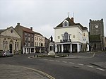 More images |
| Church of St Mary | Waterperry | Church | Saxon | 18 July 1963 | SP6295606322 51°45′07″N 1°05′22″W / 51.752062°N 1.089399°W / 51.752062; -1.089399 (Church of St Mary) | 1047587 |  More images |
| Church of St Mary, churchyard cross approximately 10 metres to south | Waterperry | Cross | Medieval | 5 June 1985 | SP6295706309 51°45′07″N 1°05′22″W / 51.751945°N 1.089387°W / 51.751945; -1.089387 (Church of St Mary, churchyard cross approximately 10 metres to south) | 1047588 |  |
| Church of St Andrew | Wheatfield | Church | 14th century | 18 July 1963 | SU6886799274 51°41′17″N 1°00′19″W / 51.688008°N 1.005174°W / 51.688008; -1.005174 (Church of St Andrew) | 1059672 | 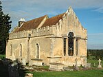 More images |
| Hardwick House | Whitchurch-on-Thames | Country house | Early 16th century | 24 October 1951 | SU6593377732 51°29′41″N 1°03′06″W / 51.494695°N 1.051651°W / 51.494695; -1.051651 (Hardwick House) | 1180567 |  More images |
| Hardwick House: Dower House approximately 5 metres west | Whitchurch-on-Thames | House | Late 17th century | 16 August 1985 | SU6592477748 51°29′41″N 1°03′06″W / 51.49484°N 1.051778°W / 51.49484; -1.051778 (Hardwick House: Dower House approximately 5 metres west) | 1059525 |  |
| Church of the Holy Rood | Woodeaton | Church | 13th century | 18 July 1963 | SP5348911898 51°48′11″N 1°13′32″W / 51.803174°N 1.225669°W / 51.803174; -1.225669 (Church of the Holy Rood) | 1047562 |  More images |
| Woodeaton Cross | Woodeaton | Village cross | Medieval | 18 July 1963 | SP5349811960 51°48′13″N 1°13′32″W / 51.80373°N 1.225529°W / 51.80373; -1.225529 (Woodeaton Cross) | 1047563 |  More images |
| The Old Brewhouse with entrance screen, Woodperry House | Woodperry, Stanton St. John | Country house | 1728–31 | 18 July 1963 | SP5751010430 51°47′22″N 1°10′03″W / 51.789578°N 1.167603°W / 51.789578; -1.167603 (The Old Brewhouse with entrance screen, Woodperry House) | 1047582 |  More images |
See also
- Grade I listed buildings in Oxfordshire
- Grade I listed buildings in Cherwell (district)
- Grade I listed buildings in Oxford
- Grade I listed buildings in Vale of White Horse
- Grade I listed buildings in West Oxfordshire
- Grade II* listed buildings in South Oxfordshire
Notes
- ^ The date given is the date used by Historic England as significant for the initial building or that of an important part in the structure's description.
- ^ Sometimes known as OSGB36, the grid reference is based on the British national grid reference system used by the Ordnance Survey.
- ^ The "List Entry Number" is a unique number assigned to each listed building and scheduled monument by Historic England.
External links
- v
- t
- e
- Bedfordshire
- Berkshire
- Bristol
- Buckinghamshire
- Cambridgeshire
- Cheshire
- Cornwall
- Cumbria
- Derbyshire
- Devon
- Dorset
- Durham
- East Sussex
- East Riding of Yorkshire
- Essex
- Gloucestershire
- Greater London
- Greater Manchester
- Hampshire
- Herefordshire
- Hertfordshire
- Isle of Wight
- Kent
- Lancashire
- Leicestershire
- Lincolnshire
- Merseyside
- Norfolk
- North Yorkshire
- Northamptonshire
- Northumberland
- Nottinghamshire
- Oxfordshire
- Rutland
- Shropshire
- Somerset
- South Yorkshire
- Staffordshire
- Suffolk
- Surrey
- Tyne and Wear
- Warwickshire
- West Midlands
- West Sussex
- West Yorkshire
- Wiltshire
- Worcestershire
- Babergh
- Bath and North East Somerset
- Bradford
- Brighton and Hove
- Broadland
- Cheltenham
- Cheshire East
- Cheshire West and Chester
- Cotswold
- Craven
- Dartford
- Dover
- Forest Heath
- Forest of Dean
- Ipswich
- Maidstone
- Mendip
- Mid Suffolk
- North Somerset
- Sedgemoor
- South Gloucestershire
- South Somerset
- St Edmundsbury
- Stroud
- Suffolk Coastal
- Taunton Deane
- Tewkesbury
- Waveney
- West Somerset
- Churches
- War memorials
- 20th century


