Grade I listed buildings in Forest Heath
Map all coordinates using OpenStreetMap
Download coordinates as:
- KML
- GPX (all coordinates)
- GPX (primary coordinates)
- GPX (secondary coordinates)

There are 12[1] Grade I listed buildings in Forest Heath, a non-metropolitan district of Suffolk, England.
In the United Kingdom, the term listed building refers to a building or other structure officially designated as being of "exceptional architectural or historic special interest"; Grade I structures are those considered to be "buildings of exceptional interest, sometimes considered to be internationally important. Just 2.5% of listed buildings are Grade I." The total number of listed buildings in England is 372,905.[2] In England, the authority for listing under the Planning (Listed Buildings and Conservation Areas) Act 1990[3] rests with English Heritage, a non-departmental public body sponsored by the Department for Culture, Media and Sport.
Forest Heath is a local government district, subdivided among 22 civil parishes, including 3 towns, that are in order of population Newmarket, Mildenhall and Brandon. Mildenhall is the administrative headquarters of the district.
Forest Heath
| Name | Location | Type | Completed [note 1] | Date designated | Grid ref.[note 2] Geo-coordinates | Entry number [note 3] | Image | Ref. |
|---|---|---|---|---|---|---|---|---|
| Church of St Peter | Brandon | Church | Medieval | 7 May 1954 | TL7770786173 52°26′41″N 0°36′48″E / 52.444619°N 0.613284°E / 52.444619; 0.613284 (Church of St Peter) | 1037592 |  More images | [4] |
| Church of St Mary | Dalham | Church | 15th century | 7 May 1954 | TL7242962556 52°14′03″N 0°31′25″E / 52.234195°N 0.523598°E / 52.234195; 0.523598 (Church of St Mary) | 1037701 |  More images | [5] |
| Church of St Martin | Exning | Church | 14th century | 28 November 1950 | TL6214065513 52°15′50″N 0°22′28″E / 52.26388°N 0.374491°E / 52.26388; 0.374491 (Church of St Martin) | 1374828 | 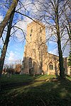 More images | [6] |
| Church of All Saints | Gazeley | Church | 14th century | 7 May 1954 | TL7193264164 52°14′56″N 0°31′02″E / 52.248793°N 0.517145°E / 52.248793; 0.517145 (Church of All Saints) | 1037675 | 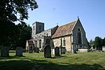 More images | [7] |
| Church of All Saints | Icklingham | Church | 14th century | 7 May 1954 | TL7757572606 52°19′22″N 0°36′15″E / 52.32282°N 0.604161°E / 52.32282; 0.604161 (Church of All Saints) | 1351332 |  More images | [8] |
| Church of St Mary | Lakenheath | Church | 15th century | 7 May 1954 | TL7145382744 52°24′57″N 0°31′11″E / 52.415819°N 0.519605°E / 52.415819; 0.519605 (Church of St Mary) | 1285945 |  More images | [9] |
| Church of St Mary | Mildenhall | Church | 15th century | 7 May 1954 | TL7102674598 52°20′34″N 0°30′33″E / 52.342789°N 0.509181°E / 52.342789; 0.509181 (Church of St Mary) | 1037561 |  More images | [10] |
| Church of St Peter | Moulton | Church | 15th century | 7 May 1954 | TL6996864145 52°14′57″N 0°29′18″E / 52.249232°N 0.488396°E / 52.249232; 0.488396 (Church of St Peter) | 1037681 |  More images | [11] |
| Church of St Mary | Santon Downham | Church | 13th century | 7 May 1954 | TL8162487612 52°27′23″N 0°40′18″E / 52.456255°N 0.671632°E / 52.456255; 0.671632 (Church of St Mary) | 1351353 | 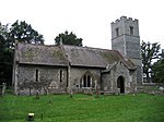 More images | [12] |
| Cross-base 2 Metres North West of Church of St Mary | Santon Downham | Cross | Late Medieval | 2 October 1984 | TL8161687625 52°27′23″N 0°40′17″E / 52.456374°N 0.671521°E / 52.456374; 0.671521 (Cross-base 2 Metres North West of Church of St Mary) | 1285595 |  More images | [13] |
| Church of St Mary | Tuddenham | Church | 14th century | 7 May 1954 | TL7380471362 52°18′46″N 0°32′54″E / 52.312853°N 0.548246°E / 52.312853; 0.548246 (Church of St Mary) | 1037584 |  More images | [14] |
| Church of All Saints | Worlington | Church | 14th century | 7 May 1954 | TL6912873856 52°20′12″N 0°28′52″E / 52.336713°N 0.480974°E / 52.336713; 0.480974 (Church of All Saints) | 1037585 |  More images | [15] |
See also
Notes
- ^ The date given is the date used by Historic England as significant for the initial building or that of an important part in the structure's description.
- ^ Sometimes known as OSGB36, the grid reference is based on the British national grid reference system used by the Ordnance Survey.
- ^ The "List Entry Number" is a unique number assigned to each listed building and scheduled monument by Historic England.
References
- ^ English Heritage - Heritage Counts: The State of the East of England Historic Environment
- ^ "Listed Buildings". English Heritage. 2010. Archived from the original on 26 January 2013. Retrieved 19 August 2011.
- ^ "Planning (Listed Buildings and Conservation Areas) Act 1990 (c. 9)". Ministry of Justice. Retrieved 17 December 2007.
- ^ Historic England. "Details from listed building database (1037592)". National Heritage List for England. Retrieved 16 April 2009.
- ^ Historic England. "Details from listed building database (1037701)". National Heritage List for England. Retrieved 16 April 2009.
- ^ Historic England. "Details from listed building database (1374828)". National Heritage List for England. Retrieved 16 April 2009.
- ^ Historic England. "Details from listed building database (1037675)". National Heritage List for England. Retrieved 16 April 2009.
- ^ Historic England. "Details from listed building database (1351332)". National Heritage List for England. Retrieved 16 April 2009.
- ^ Historic England. "Details from listed building database (1285945)". National Heritage List for England. Retrieved 16 April 2009.
- ^ Historic England. "Details from listed building database (1037561)". National Heritage List for England. Retrieved 16 April 2009.
- ^ Historic England. "Details from listed building database (1037681)". National Heritage List for England. Retrieved 16 April 2009.
- ^ Historic England. "Details from listed building database (1351353)". National Heritage List for England. Retrieved 16 April 2009.
- ^ Historic England. "Details from listed building database (1285595)". National Heritage List for England. Retrieved 16 April 2009.
- ^ Historic England. "Details from listed building database (1037584)". National Heritage List for England. Retrieved 16 April 2009.
- ^ Historic England. "Details from listed building database (1037585)". National Heritage List for England. Retrieved 16 April 2009.
External links
![]() Media related to Grade I listed buildings in Forest Heath at Wikimedia Commons
Media related to Grade I listed buildings in Forest Heath at Wikimedia Commons
- v
- t
- e
- Bedfordshire
- Berkshire
- Bristol
- Buckinghamshire
- Cambridgeshire
- Cheshire
- Cornwall
- Cumbria
- Derbyshire
- Devon
- Dorset
- Durham
- East Sussex
- East Riding of Yorkshire
- Essex
- Gloucestershire
- Greater London
- Greater Manchester
- Hampshire
- Herefordshire
- Hertfordshire
- Isle of Wight
- Kent
- Lancashire
- Leicestershire
- Lincolnshire
- Merseyside
- Norfolk
- North Yorkshire
- Northamptonshire
- Northumberland
- Nottinghamshire
- Oxfordshire
- Rutland
- Shropshire
- Somerset
- South Yorkshire
- Staffordshire
- Suffolk
- Surrey
- Tyne and Wear
- Warwickshire
- West Midlands
- West Sussex
- West Yorkshire
- Wiltshire
- Worcestershire
- Babergh
- Bath and North East Somerset
- Bradford
- Brighton and Hove
- Broadland
- Cheltenham
- Cheshire East
- Cheshire West and Chester
- Cotswold
- Craven
- Dartford
- Dover
- Forest Heath
- Forest of Dean
- Ipswich
- Maidstone
- Mendip
- Mid Suffolk
- North Somerset
- Sedgemoor
- South Gloucestershire
- South Somerset
- St Edmundsbury
- Stroud
- Suffolk Coastal
- Taunton Deane
- Tewkesbury
- Waveney
- West Somerset
- Churches
- War memorials
- 20th century


