Grade I listed buildings in Northumberland

Map all coordinates using OpenStreetMap
Download coordinates as:
- KML
- GPX (all coordinates)
- GPX (primary coordinates)
- GPX (secondary coordinates)
There are over 9000 Grade I listed buildings in England. This page is a list of these buildings in the county of Northumberland, by parish.
Northumberland
| Name | Location | Type | Completed [note 1] | Date designated | Grid ref.[note 2] Geo-coordinates | Entry number [note 3] | Image |
|---|---|---|---|---|---|---|---|
| Church of St Michael | Alnham, Northumberland | Parish Church | Saxon | 21 October 1953 | NT9908610993 55°23′34″N 2°00′58″W / 55.392892°N 2.01598°W / 55.392892; -2.01598 (Church of St Michael) | 1303455 |  More images |
| Canongate Bridge | Alnwick, Northumberland | Bridge | 1821 | 20 February 1952 | NU1809914002 55°25′11″N 1°42′56″W / 55.4196°N 1.715632°W / 55.4196; -1.715632 (Canongate Bridge) | 1041491 |  More images |
| Church of St Michael | Alnwick, Northumberland | Parish Church | c. 1464 | 25 August 1977 | NU1838613703 55°25′01″N 1°42′40″W / 55.416903°N 1.711118°W / 55.416903; -1.711118 (Church of St Michael) | 1041546 |  More images |
| Denwick Bridge over River Aln | Alnwick, Northumberland | Road Bridge | 1766 | 10 January 1953 | NU1975013813 55°25′04″N 1°41′22″W / 55.417839°N 1.689564°W / 55.417839; -1.689564 (Denwick Bridge over River Aln) | 1042043 |  More images |
| Northumberland Hall (Assembly Rooms) | Alnwick, Northumberland | Assembly Hall | 1826 | 20 February 1952 | NU1864613283 55°24′47″N 1°42′25″W / 55.41312°N 1.707039°W / 55.41312; -1.707039 (Northumberland Hall (Assembly Rooms)) | 1041460 |  More images |
| Percy Tenantry Column | Alnwick, Northumberland | Column | 1816 | 20 February 1952 | NU1914613037 55°24′39″N 1°41′57″W / 55.41089°N 1.699158°W / 55.41089; -1.699158 (Percy Tenantry Column) | 1041405 |  More images |
| The Castle, Stable Court and covered Riding School including West Wall of Riding School | Alnwick, Northumberland | Kitchen | 1138 | 20 February 1952 | NU1868513574 55°24′57″N 1°42′23″W / 55.415733°N 1.706404°W / 55.415733; -1.706404 (The Castle, Stable Court and covered Riding School including West Wall of Riding School) | 1371308 |  More images |
| The Hotspur Gateway or Bondgate Tower | Alnwick, Northumberland | Gate | c. 1450 | 20 February 1952 | NU1885513229 55°24′45″N 1°42′13″W / 55.412626°N 1.703742°W / 55.412626; -1.703742 (The Hotspur Gateway or Bondgate Tower) | 1041513 | 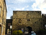 More images |
| The Lion Bridge | Alnwick, Northumberland | Bridge | 1773 | 10 January 1953 | NU1861913813 55°25′04″N 1°42′27″W / 55.417883°N 1.70743°W / 55.417883; -1.70743 (The Lion Bridge) | 1178596 |  More images |
| Town Hall | Alnwick, Northumberland | Town Hall | 1731 | 20 February 1952 | NU1860713314 55°24′48″N 1°42′28″W / 55.4134°N 1.707653°W / 55.4134; -1.707653 (Town Hall) | 1157140 | 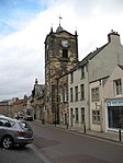 More images |
| Bothal Castle Gatehouse and adjacent Wing to West | Bothal, Ashington, Northumberland | Castle | c. 1343 | 14 April 1949 | NZ2398586520 55°10′21″N 1°37′30″W / 55.172409°N 1.624985°W / 55.172409; -1.624985 (Bothal Castle Gatehouse and adjacent Wing to West) | 1153715 |  More images |
| Bothal Castle Remains of Curtain Wall to South of Residential Block | Bothal, Ashington, Northumberland | Castle | 1343 | 14 April 1949 | NZ2401786464 55°10′19″N 1°37′28″W / 55.171904°N 1.624487°W / 55.171904; -1.624487 (Bothal Castle Remains of Curtain Wall to South of Residential Block) | 1041365 |  |
| Church of St Andrew | Bothal, Ashington, Northumberland | Cross | Pre-Conquest | 18 December 1986 | NZ2398986621 55°10′24″N 1°37′30″W / 55.173316°N 1.624913°W / 55.173316; -1.624913 (Church of St Andrew) | 1371383 |  More images |
| Bamburgh Castle | Bamburgh, Northumberland | Apartment | 19th century | 4 January 1952 | NU1831935114 55°36′33″N 1°42′39″W / 55.609289°N 1.710771°W / 55.609289; -1.710771 (Bamburgh Castle) | 1280155 |  More images |
| Church of St Aidan | Bamburgh, Northumberland | Parish Church | 12th century | 22 December 1969 | NU1784934968 55°36′29″N 1°43′06″W / 55.607995°N 1.71824°W / 55.607995; -1.71824 (Church of St Aidan) | 1042269 |  More images |
| Church of St Cuthbert | Beltingham, Bardon Mill, Northumberland | Cross | 12th century | 24 November 1967 | NY7896463963 54°58′11″N 2°19′48″W / 54.969838°N 2.330125°W / 54.969838; -2.330125 (Church of St Cuthbert) | 1370817 |  More images |
| Willimontswick Gatehouse and adjacent Ranges | Willimontswick, Bardon Mill, Northumberland | Fortified Manor House | 16th century | 24 November 1967 | NY7706463645 54°58′01″N 2°21′35″W / 54.966896°N 2.359778°W / 54.966896; -2.359778 (Willimontswick Gatehouse and adjacent Ranges) | 1370843 |  More images |
| Belford Hall | Belford, Belford, Northumberland | Apartment | 1969 | 22 December 1969 | NU1109934240 55°36′06″N 1°49′31″W / 55.601653°N 1.825413°W / 55.601653; -1.825413 (Belford Hall) | 1233314 |  More images |
| Church of St Cuthbert | Bellingham, Northumberland | Parish Church | 13th century | 10 November 1951 | NY8376783252 55°08′36″N 2°15′22″W / 55.143349°N 2.256206°W / 55.143349; -2.256206 (Church of St Cuthbert) | 1370442 |  More images |
| Belsay Castle | Belsay, Northumberland | House | 1614 | 27 August 1952 | NZ0847578554 55°06′05″N 1°52′07″W / 55.101332°N 1.868719°W / 55.101332; -1.868719 (Belsay Castle) | 1042837 | 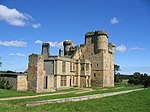 More images |
| Belsay Hall | Belsay, Belsay, Northumberland | Country House | 1810-1817 | 27 August 1952 | NZ0883578363 55°05′59″N 1°51′47″W / 55.09961°N 1.863083°W / 55.09961; -1.863083 (Belsay Hall) | 1304489 |  More images |
| Church of St Andrew | Bolam, Northumberland | Parish Church | Late Saxon | 28 April 1969 | NZ0924782602 55°08′16″N 1°51′23″W / 55.137694°N 1.856491°W / 55.137694; -1.856491 (Church of St Andrew) | 1304102 | 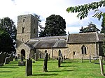 More images |
| Shortflatt Tower | Shortflatt, Belsay, Northumberland | House | Early 17th century | 27 August 1952 | NZ0793780995 55°07′24″N 1°52′38″W / 55.123276°N 1.877084°W / 55.123276; -1.877084 (Shortflatt Tower) | 1042821 |  Upload Photo |
| Bitchfield Tower | West Bitchfield, Belsay, Northumberland | Pele Tower/House | 14th century | 27 August 1952 | NZ0907877061 55°05′16″N 1°51′34″W / 55.087906°N 1.859316°W / 55.087906; -1.859316 (Bitchfield Tower) | 1303894 |  More images |
| Bell Tower and Remains of Town Walls | Berwick-upon-Tweed, Northumberland | Town Defences | Elizabethan | 26 May 1971 | NT9978553526 55°46′30″N 2°00′18″W / 55.775064°N 2.004996°W / 55.775064; -2.004996 (Bell Tower and Remains of Town Walls) | 1370858 |  More images |
| Berwick Bridge | Berwick-upon-Tweed, Northumberland | Bridge | 1611-34 | 1 August 1952 | NT9955652704 55°46′04″N 2°00′31″W / 55.767678°N 2.008644°W / 55.767678; -2.008644 (Berwick Bridge) | 1041695 | 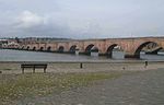 More images |
| Berwick Castle - Ruins of the Constable Tower (part of Berwick Castle) | Berwick-upon-Tweed, Northumberland | Tower | 13th century | 1 August 1952 | NT9940653338 55°46′24″N 2°00′40″W / 55.773374°N 2.011037°W / 55.773374; -2.011037 (Berwick Castle - Ruins of the Constable Tower (part of Berwick Castle)) | 1371223 | Upload Photo |
| Berwick Castle (fragments, including Towers and Walls and Steps) | Berwick-upon-Tweed, Northumberland | Castle | After 1611 | 1 August 1952 | NT9932853410 55°46′26″N 2°00′44″W / 55.774021°N 2.01228°W / 55.774021; -2.01228 (Berwick Castle (fragments, including Towers and Walls and Steps)) | 1290213 |  More images |
| Church of Holy Trinity | Berwick-upon-Tweed, Northumberland | Church | 1648-52 | 1 August 1952 | NU0003653199 55°46′20″N 2°00′04″W / 55.772126°N 2.000994°W / 55.772126; -2.000994 (Church of Holy Trinity) | 1233676 |  More images |
| Clock House Building, Berwick Barracks Museum | Berwick-upon-Tweed, Northumberland | Barracks | Late 19th century | 26 May 1971 | NU0008953043 55°46′15″N 2°00′01″W / 55.770724°N 2.00015°W / 55.770724; -2.00015 (Clock House Building, Berwick Barracks Museum) | 1244772 |  More images |
| East Barrack, Berwick Barracks Museum | Berwick-upon-Tweed, Northumberland | Barracks | 1721 | 26 May 1971 | NU0012653080 55°46′16″N 1°59′58″W / 55.771057°N 1.99956°W / 55.771057; -1.99956 (East Barrack, Berwick Barracks Museum) | 1042432 |  More images |
| Cowport Gate | Cowport, Berwick-upon-Tweed, Northumberland | Gate | 26 May 1971 | NU0013153174 55°46′19″N 1°59′58″W / 55.771901°N 1.99948°W / 55.771901; -1.99948 (Cowport Gate) | 1042478 |  More images | |
| Gateway and Guard House, Berwick Barracks Museum | Berwick-upon-Tweed, Northumberland | Gate | 1719-1721 | 26 May 1971 | NU0009053115 55°46′17″N 2°00′00″W / 55.771371°N 2.000134°W / 55.771371; -2.000134 (Gateway and Guard House, Berwick Barracks Museum) | 1244721 |  More images |
| Premises occupied by Card Shop, Town House Coffee House and Boutique | Berwick-upon-Tweed, Northumberland | Coffee House | 1971 | 26 May 1971 | NT9992452897 55°46′10″N 2°00′10″W / 55.769412°N 2.002779°W / 55.769412; -2.002779 (Premises occupied by Card Shop, Town House Coffee House and Boutique) | 1042466 |  |
| Royal Border Bridge | Berwick-upon-Tweed, Northumberland | Bridge | 1847 | 1 August 1952 | NT9928553252 55°46′21″N 2°00′47″W / 55.772601°N 2.012965°W / 55.772601; -2.012965 (Royal Border Bridge) | 1211052 | 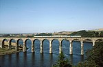 More images |
| Scotsgate | Berwick-upon-Tweed, Northumberland | Gate | Elizabethan | 26 May 1971 | NT9969453077 55°46′16″N 2°00′23″W / 55.77103°N 2.006446°W / 55.77103; -2.006446 (Scotsgate) | 1370836 |  More images |
| Shore Gate | Berwick-upon-Tweed, Northumberland | Town Gate | 1760 | 26 May 1971 | NT9985852644 55°46′02″N 2°00′14″W / 55.767139°N 2.003831°W / 55.767139; -2.003831 (Shore Gate) | 1233671 |  More images |
| The Custom House | Berwick-upon-Tweed, Northumberland | House | 18th century | 26 May 1971 | NT9988252626 55°46′01″N 2°00′12″W / 55.766978°N 2.003449°W / 55.766978; -2.003449 (The Custom House) | 1042437 |  More images |
| Town Fortifications including the Bell Tower | Berwick-upon-Tweed, Northumberland | Castle | 1760s | 26 May 1971 | NU0022152855 55°46′09″N 1°59′53″W / 55.769035°N 1.998046°W / 55.769035; -1.998046 (Town Fortifications including the Bell Tower) | 1290222 |  More images |
| Town Hall | Berwick-upon-Tweed, Northumberland | Town hall | 1754-60 | 1 August 1952 | NT9991452901 55°46′10″N 2°00′11″W / 55.769448°N 2.002939°W / 55.769448; -2.002939 (Town Hall) | 1290051 |  More images |
| Wall of Berwick Castle to North of the Ruins of Constable Tower | Berwick-upon-Tweed, Northumberland | Castle | 26 May 1971 | NT9941053348 55°46′24″N 2°00′40″W / 55.773464°N 2.010973°W / 55.773464; -2.010973 (Wall of Berwick Castle to North of the Ruins of Constable Tower) | 1041696 | Upload Photo | |
| West Barrack and attached Perimeter Wall, Berwick Barrack Museum | Berwick-upon-Tweed, Northumberland | Wall | 1719-1721 | 26 May 1971 | NU0007653072 55°46′16″N 2°00′01″W / 55.770985°N 2.000357°W / 55.770985; -2.000357 (West Barrack and attached Perimeter Wall, Berwick Barrack Museum) | 1244722 |  More images |
| Church of Holy Trinity | Old Bewick, Bewick, Northumberland | Parish Church | 12th century | 21 September 1951 | NU0680022149 55°29′35″N 1°53′38″W / 55.493089°N 1.893932°W / 55.493089; -1.893932 (Church of Holy Trinity) | 1042412 |  More images |
| Abbey Gatehouse with Post Office | Blanchland, Northumberland | Abbey | 15th century | 18 June 1986 | NY9656950369 54°50′53″N 2°03′18″W / 54.848114°N 2.054959°W / 54.848114; -2.054959 (Abbey Gatehouse with Post Office) | 1153918 |  |
| Church of St Mary | Blanchland, Northumberland | Abbey | 1165 | 15 April 1969 | NY9662650400 54°50′54″N 2°03′15″W / 54.848393°N 2.054071°W / 54.848393; -2.054071 (Church of St Mary) | 1304226 |  More images |
| Churchyard Cross 17m West of Door of Church of St. Mary | Blanchland, Northumberland | Cross | 13th century | 18 June 1986 | NY9659850408 54°50′54″N 2°03′16″W / 54.848465°N 2.054508°W / 54.848465; -2.054508 (Churchyard Cross 17m West of Door of Church of St. Mary) | 1045418 |  More images |
| House adjacent to Abbey Gatehouse | Blanchland, Northumberland | Abbey | 13th century | 14 April 1969 | NY9656350366 54°50′53″N 2°03′18″W / 54.848087°N 2.055052°W / 54.848087; -2.055052 (House adjacent to Abbey Gatehouse) | 1370257 | |
| The Priory Church | Brinkburn Priory, Brinkburn, Northumberland | Priory church | 16th century | 21 October 1953 | NZ1159398324 55°16′44″N 1°49′09″W / 55.27892°N 1.819053°W / 55.27892; -1.819053 (The Priory Church) | 1303969 |  More images |
| Weldon Bridge over River Coquet and Wall to North West | Weldon Bridge, Brinkburn, Northumberland | Wall | c. 1760 | 10 January 1953 | NZ1379698511 55°16′50″N 1°47′04″W / 55.280544°N 1.784365°W / 55.280544; -1.784365 (Weldon Bridge over River Coquet and Wall to North West) | 1371161 |  More images |
| Bywell Castle Gatehouse | Bywell, Northumberland | Gatehouse | Early 15th century | 15 April 1969 | NZ0494261784 54°57′02″N 1°55′28″W / 54.950682°N 1.924371°W / 54.950682; -1.924371 (Bywell Castle Gatehouse) | 1370558 |  More images |
| Church of St Andrew | Bywell, Northumberland | Cross | Saxon | 15 April 1969 | NZ0483961492 54°56′53″N 1°55′34″W / 54.948059°N 1.925984°W / 54.948059; -1.925984 (Church of St Andrew) | 1044831 |  More images |
| Church of St Peter | Bywell, Northumberland | Parish Church | Pre-Conquest | 15 April 1969 | NZ0492661428 54°56′51″N 1°55′29″W / 54.947483°N 1.924627°W / 54.947483; -1.924627 (Church of St Peter) | 1044828 |  More images |
| Callaly Castle | Callaly, Northumberland | Country House | 14th century | 21 October 1953 | NU0527009879 55°22′58″N 1°55′06″W / 55.382856°N 1.918375°W / 55.382856; -1.918375 (Callaly Castle) | 1155463 |  More images |
| Capheaton Hall and Walls attached | Capheaton, Northumberland | Country House | 1668 | 27 August 1952 | NZ0389980497 55°07′08″N 1°56′25″W / 55.118848°N 1.940407°W / 55.118848; -1.940407 (Capheaton Hall and Walls attached) | 1154285 | 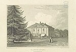 More images |
| East Shaftoe Hall | Shaftoe, Capheaton, Northumberland | House | 16th century | 27 August 1952 | NZ0590781797 55°07′50″N 1°54′32″W / 55.13051°N 1.908898°W / 55.13051; -1.908898 (East Shaftoe Hall) | 1154609 |  More images |
| Cragside | Cartington, Northumberland | House | 1864 | 21 October 1953 | NU0737502173 55°18′49″N 1°53′07″W / 55.313586°N 1.885351°W / 55.313586; -1.885351 (Cragside) | 1042076 |  More images |
| Ruins of Cartington Castle | Cartington, Northumberland | Castle | Late 16th or early 17th century | 21 October 1953 | NU0388104533 55°20′05″N 1°56′25″W / 55.334831°N 1.940369°W / 55.334831; -1.940369 (Ruins of Cartington Castle) | 1042073 |  More images |
| Weetwood Bridge | Weetwood, Chatton, Northumberland | Bridge | 16th century | 21 September 1951 | NU0185529466 55°33′32″N 1°58′20″W / 55.558878°N 1.97215°W / 55.558878; -1.97215 (Weetwood Bridge) | 1042383 |  More images |
| Chillingham Castle | Chillingham, Northumberland | Castle | 14th century | 21 September 1951 | NU0615025784 55°31′33″N 1°54′15″W / 55.52576°N 1.904141°W / 55.52576; -1.904141 (Chillingham Castle) | 1042387 | 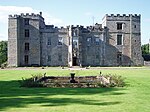 More images |
| Church of St Peter | Chillingham, Northumberland | Parish Church | 12th century | 21 September 1951 | NU0621325959 55°31′38″N 1°54′11″W / 55.527331°N 1.903139°W / 55.527331; -1.903139 (Church of St Peter) | 1232739 |  More images |
| Chapel at Chipchase Castle | Chipchase, Chollerton, Northumberland | Chapel | Medieval | 5 September 1985 | NY8836075697 55°04′32″N 2°11′02″W / 55.075591°N 2.183838°W / 55.075591; -2.183838 (Chapel at Chipchase Castle) | 1044897 | 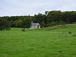 More images |
| Chipchase Castle | Chipchase, Chollerton, Northumberland | Country House | 14th century | 20 October 1952 | NY8825775731 55°04′33″N 2°11′08″W / 55.075894°N 2.185453°W / 55.075894; -2.185453 (Chipchase Castle) | 1155161 |  More images |
| Church of St Giles | Chollerton, Northumberland | Altar | Roman | 15 April 1969 | NY9310871917 55°02′30″N 2°06′34″W / 55.041713°N 2.109384°W / 55.041713; -2.109384 (Church of St Giles) | 1155271 |  More images |
| Aydon Castle Main Buildings and Courtyard Walls | Aydon, Corbridge, Northumberland | Fortified Manor House | c. 1280 | 24 May 1988 | NZ0014366283 54°59′28″N 1°59′57″W / 54.991135°N 1.999298°W / 54.991135; -1.999298 (Aydon Castle Main Buildings and Courtyard Walls) | 1303707 | 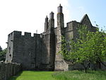 More images |
| Chapel | Dilston Hall, Corbridge, Northumberland | Roman Catholic Chapel | Early 17th century | 15 April 1969 | NY9757463253 54°57′50″N 2°02′22″W / 54.9639°N 2.039421°W / 54.9639; -2.039421 (Chapel) | 1303600 |  More images |
| Church of St Andrew | Corbridge, Northumberland | Parish Church | Late 7th or 8th century | 15 April 1969 | NY9883364433 54°58′28″N 2°01′11″W / 54.974508°N 2.019763°W / 54.974508; -2.019763 (Church of St Andrew) | 1303508 |  More images |
| Corbridge Bridge | Corbridge, Northumberland | Bridge | 1674 | 15 April 1969 | NY9888864173 54°58′20″N 2°01′08″W / 54.972172°N 2.018903°W / 54.972172; -2.018903 (Corbridge Bridge) | 1044808 |  More images |
| Dilston Castle | Corbridge, Northumberland | Country House | c. 1630 | 15 April 1969 | NY9755363286 54°57′51″N 2°02′23″W / 54.964196°N 2.039749°W / 54.964196; -2.039749 (Dilston Castle) | 1044775 | 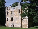 More images |
| Low Hall | Corbridge, Northumberland | House | Late 16th century | 20 October 1952 | NY9912864321 54°58′25″N 2°00′55″W / 54.973503°N 2.015154°W / 54.973503; -2.015154 (Low Hall) | 1044784 |  More images |
| Outer Bailey Walls and attached Farm buildings | Aydon, Corbridge, Northumberland | Privy House | 14th century | 24 May 1988 | NZ0010866291 54°59′28″N 1°59′59″W / 54.991206°N 1.999845°W / 54.991206; -1.999845 (Outer Bailey Walls and attached Farm buildings) | 1044803 |  |
| Vicars Pele | Corbridge, Northumberland | Tower House | c. 1400 | 15 April 1969 | NY9885064408 54°58′27″N 2°01′10″W / 54.974284°N 2.019497°W / 54.974284; -2.019497 (Vicars Pele) | 1044750 |  More images |
| Twizell Bridge | Cornhill-on-Tweed, Northumberland | Bridge | Later additions | 22 December 1969 | NT8848443310 55°40′59″N 2°11′05″W / 55.683133°N 2.18471°W / 55.683133; -2.18471 (Twizell Bridge) | 1042199 |  More images |
| Dunstanburgh Castle | Dunstanburgh, Craster, Northumberland | Castle | Early 14th century | 31 December 1969 | NU2568421798 55°29′22″N 1°35′42″W / 55.489313°N 1.595095°W / 55.489313; -1.595095 (Dunstanburgh Castle) | 1153477 |  More images |
| Alnwick Abbey Gatehouse | Hulne Park, Denwick, Northumberland | Abbey | Late 14th century | 31 December 1969 | NU1786114075 55°25′13″N 1°43′10″W / 55.420265°N 1.719388°W / 55.420265; -1.719388 (Alnwick Abbey Gatehouse) | 1042051 |  More images |
| Brizlee Tower | Hulne Park, Denwick, Northumberland | Prospect Tower | 1781 | 31 December 1969 | NU1580214747 55°25′35″N 1°45′07″W / 55.426373°N 1.751877°W / 55.426373; -1.751877 (Brizlee Tower) | 1076985 |  More images |
| Denwick Bridge | Denwick, Northumberland | Bridge | 1765 | 20 February 1952 | NU1975013814 55°25′04″N 1°41′22″W / 55.417848°N 1.689564°W / 55.417848; -1.689564 (Denwick Bridge) | 1371329 | More images |
| Heiferlaw Tower | Denwick, Northumberland | Watch Tower | 1470-1489 | 31 December 1969 | NU1826917715 55°27′11″N 1°42′46″W / 55.452957°N 1.712705°W / 55.452957; -1.712705 (Heiferlaw Tower) | 1304282 | 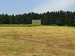 More images |
| Hulne Friary Curtain Wall and attached Structure | Hulne Park, Denwick, Northumberland | House | 20th century | 31 December 1969 | NU1637215667 55°26′05″N 1°44′34″W / 55.434621°N 1.742817°W / 55.434621; -1.742817 (Hulne Friary Curtain Wall and attached Structure) | 1042012 |  |
| Hulne Friary Summerhouse and Tower | Hulne Park, Denwick, Northumberland | Tower | 1488 | 31 December 1969 | NU1633915723 55°26′06″N 1°44′36″W / 55.435126°N 1.743336°W / 55.435126; -1.743336 (Hulne Friary Summerhouse and Tower) | 1049118 |  |
| Hulne Priory; Ruins of Church and Claustral Buildings | Hulne Park, Denwick, Northumberland | House | 16th century | 31 December 1969 | NU1637315700 55°26′06″N 1°44′34″W / 55.434918°N 1.7428°W / 55.434918; -1.7428 (Hulne Priory; Ruins of Church and Claustral Buildings) | 1042054 |  More images |
| The Lion Bridge over River Aln | Alnwick, Denwick, Northumberland | Bridge | 1773 | 10 January 1953 | NU1862113820 55°25′05″N 1°42′27″W / 55.417946°N 1.707398°W / 55.417946; -1.707398 (The Lion Bridge over River Aln) | 1304367 |  More images |
| Church of St Mary and St Michael | Doddington, Northumberland | Parish Church | 13th century | 15 May 1986 | NT9957132234 55°35′02″N 2°00′30″W / 55.583752°N 2.008365°W / 55.583752; -2.008365 (Church of St Mary and St Michael) | 1155168 |  More images |
| Church of St John the Baptist | Edlingham, Northumberland | Cross | 11th or 12th century | 31 December 1969 | NU1144409116 55°22′33″N 1°49′15″W / 55.375896°N 1.820962°W / 55.375896; -1.820962 (Church of St John the Baptist) | 1041990 |  More images |
| Edlingham Castle Ruins | Edlingham, Northumberland | Castle | 1295-1300 | 13 December 1969 | NU1161709198 55°22′36″N 1°49′06″W / 55.376629°N 1.818229°W / 55.376629; -1.818229 (Edlingham Castle Ruins) | 1042032 |  More images |
| Church of St Cuthbert | Elsdon, Northumberland | Parish Church | 12th century | 21 October 1953 | NY9364793281 55°14′01″N 2°06′05″W / 55.233696°N 2.101436°W / 55.233696; -2.101436 (Church of St Cuthbert) | 1155072 |  More images |
| Elsdon Tower | Elsdon, Northumberland | Pele Tower | Before 1415 | 21 October 1953 | NY9361293412 55°14′06″N 2°06′07″W / 55.234873°N 2.10199°W / 55.234873; -2.10199 (Elsdon Tower) | 1371439 |  More images |
| Church of the Holy Trinity | Embleton, Northumberland | Parish Church | Late 11th century | 31 December 1969 | NU2307122487 55°29′44″N 1°38′11″W / 55.495633°N 1.636388°W / 55.495633; -1.636388 (Church of the Holy Trinity) | 1041822 |  More images |
| The Old Vicarage | Embleton, Northumberland | Bastle | Early 14th century | 10 January 1953 | NU2305322444 55°29′43″N 1°38′12″W / 55.495248°N 1.636677°W / 55.495248; -1.636677 (The Old Vicarage) | 1041824 |  More images |
| Coupland Castle | Coupland, Ewart, Northumberland | House | 18th century | 21 September 1951 | NT9353431156 55°34′26″N 2°06′15″W / 55.574022°N 2.104106°W / 55.574022; -2.104106 (Coupland Castle) | 1042343 |  More images |
| Bellister Castle | Featherstone, Northumberland | House | Medieval | 10 June 1952 | NY7006862959 54°57′37″N 2°28′08″W / 54.960359°N 2.468976°W / 54.960359; -2.468976 (Bellister Castle) | 1045292 |  More images |
| Featherstone Castle | Featherstone, Northumberland | Country House | Early 14th century | 10 June 1952 | NY6737860955 54°56′32″N 2°30′39″W / 54.942182°N 2.510755°W / 54.942182; -2.510755 (Featherstone Castle) | 1370307 |  More images |
| Church of St Michael and All Angles | Felton, Northumberland | Church | c. 1200 | 15 September 1988 | NU1821300199 55°17′44″N 1°42′53″W / 55.295569°N 1.714724°W / 55.295569; -1.714724 (Church of St Michael and All Angles) | 1041881 |  More images |
| Etal Castle Gate Tower, South Curtain Wall and South West Tower | Etal, Ford, Northumberland | Castle | 1342 | 21 September 1951 | NT9255639314 55°38′50″N 2°07′11″W / 55.647309°N 2.11984°W / 55.647309; -2.11984 (Etal Castle Gate Tower, South Curtain Wall and South West Tower) | 1153966 |  More images |
| Etal Castle Great Tower | Etal, Ford, Northumberland | Castle | 1342 | 10 March 1988 | NT9249939317 55°38′50″N 2°07′15″W / 55.647335°N 2.120746°W / 55.647335; -2.120746 (Etal Castle Great Tower) | 1042183 | 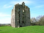 More images |
| Ford Castle | Ford, Northumberland | Castle | 14th century | 21 September 1951 | NT9441637541 55°37′53″N 2°05′25″W / 55.631404°N 2.09025°W / 55.631404; -2.09025 (Ford Castle) | 1371004 |  More images |
| Ford Castle Flagpole Tower and Forecourt Wall attached to North | Ford Castle, Ford, Northumberland | Castle | 14th century | 10 March 1988 | NT9441437493 55°37′51″N 2°05′25″W / 55.630972°N 2.090281°W / 55.630972; -2.090281 (Ford Castle Flagpole Tower and Forecourt Wall attached to North) | 1154034 |  |
| Ford Castle Portcullis Gate, Armoury Tower and Forecourt Walls to Ford Castle | Ford Castle, Ford, Northumberland | Castle | 1791 | 10 March 1988 | NT9445437462 55°37′50″N 2°05′23″W / 55.630694°N 2.089645°W / 55.630694; -2.089645 (Ford Castle Portcullis Gate, Armoury Tower and Forecourt Walls to Ford Castle) | 1042185 |  |
| Hadrian's Wall, Milecastles and Turrets | Greenhead, Northumberland | Wall | 122 AD | 24 November 1967 | NY6826366742 54°59′39″N 2°29′51″W / 54.994241°N 2.497584°W / 54.994241; -2.497584 (Hadrian's Wall, Milecastles and Turrets) | 1155916 |  More images |
| Dally Castle | Greystead, Northumberland | Castle | 13th century | 7 January 1988 | NY7748284384 55°09′12″N 2°21′18″W / 55.153274°N 2.354895°W / 55.153274; -2.354895 (Dally Castle) | 1044856 |  More images |
| Snabdaugh Farmhouse and attached Cottage | Snabdaugh, Greystead, Northumberland | House | 18th century | 7 January 1988 | NY7868684679 55°09′22″N 2°20′10″W / 55.155978°N 2.336025°W / 55.155978; -2.336025 (Snabdaugh Farmhouse and attached Cottage) | 1370511 |  More images |
| Church of the Holy Cross | Haltwhistle, Northumberland | Parish Church | Early 13th century | 24 November 1967 | NY7075564030 54°58′12″N 2°27′30″W / 54.970024°N 2.458357°W / 54.970024; -2.458357 (Church of the Holy Cross) | 1045233 |  More images |
| Hadrian's Wall Milecastle and Turrets | Haltwhistle, Northumberland | Frontier Defence | 122 AD | 24 November 1967 | NY7193666812 54°59′42″N 2°26′25″W / 54.995091°N 2.440183°W / 54.995091; -2.440183 (Hadrian's Wall Milecastle and Turrets) | 1156053 |  More images |
| Harbottle Castle | Harbottle Village, Harbottle, Northumberland | Motte and Bailey | 13th century | 21 October 1953 | NT9323004796 55°20′14″N 2°06′30″W / 55.337161°N 2.108275°W / 55.337161; -2.108275 (Harbottle Castle) | 1041281 |  More images |
| The Lady's Well | Holystone, Northumberland | Statue | 15th century | 21 October 1953 | NT9528202913 55°19′13″N 2°04′33″W / 55.320265°N 2.075894°W / 55.320265; -2.075894 (The Lady's Well) | 1041283 |  More images |
| Church of St Andrew | Hartburn, Northumberland | Church | 18th century | 20 October 1969 | NZ0902886013 55°10′06″N 1°51′35″W / 55.168349°N 1.859819°W / 55.168349; -1.859819 (Church of St Andrew) | 1371047 |  More images |
| Haydon Old Church | Old Haydon, Haydon, Northumberland | Parish Church | 12th century | 15 April 1969 | NY8422965294 54°58′55″N 2°14′53″W / 54.981994°N 2.247958°W / 54.981994; -2.247958 (Haydon Old Church) | 1042512 |  More images |
| Langley Castle | Langley, Haydon, Northumberland | Castle | c. 1350 | 20 October 1952 | NY8347662473 54°57′24″N 2°15′34″W / 54.95662°N 2.25956°W / 54.95662; -2.25956 (Langley Castle) | 1154672 |  More images |
| Cockle Park Tower | Cockle Park, Hebron, Northumberland | Tower House | Early 16th century | 30 January 1986 | NZ2008991157 55°12′51″N 1°41′09″W / 55.214249°N 1.685822°W / 55.214249; -1.685822 (Cockle Park Tower) | 1042088 |  More images |
| Church of St Andrew | Heddon-on-the-Wall, Northumberland | Sundial | Saxon | 28 April 1969 | NZ1338666892 54°59′47″N 1°47′32″W / 54.99643°N 1.792298°W / 54.99643; -1.792298 (Church of St Andrew) | 1042770 |  More images |
| Hadrian's Wall Milecastles and Turrets | Henshaw, Northumberland | Frontier Defence | 122 AD | 24 November 1967 | NY7473267586 55°00′08″N 2°23′48″W / 55.002196°N 2.396551°W / 55.002196; -2.396551 (Hadrian's Wall Milecastles and Turrets) | 1156389 |  More images |
| St Wilfrid's Gateway, the Priory Gatehouse | Hexham, Northumberland | Gate | 1976 | 2 October 1951 | NY9350264200 54°58′21″N 2°06′11″W / 54.972372°N 2.10304°W / 54.972372; -2.10304 (St Wilfrid's Gateway, the Priory Gatehouse) | 1042616 |  More images |
| The Claustral Buildings of the former Augustinian Priory of St Andrew now incorporated into Hexham Court House and Hexham House Clinic | Hexham, Northumberland | Gate | 1976 | 2 October 1951 | NY9349664079 54°58′17″N 2°06′11″W / 54.971285°N 2.103131°W / 54.971285; -2.103131 (The Claustral Buildings of the former Augustinian Priory of St Andrew now incorporated into Hexham Court House and Hexham House Clinic) | 1370776 |  More images |
| The Manor Office | Hexham, Northumberland | Manor House | Mid-19th century | 2 October 1951 | NY9369864082 54°58′17″N 2°06′00″W / 54.971315°N 2.099976°W / 54.971315; -2.099976 (The Manor Office) | 1281526 |  More images |
| The Moot Hall | Hexham, Northumberland | Privy House | Late 14th or early 15th century | 2 October 1951 | NY9364564111 54°58′18″N 2°06′03″W / 54.971575°N 2.100804°W / 54.971575; -2.100804 (The Moot Hall) | 1042577 |  More images |
| The Priory Church of St Andrew | Hexham, Northumberland | Church | 7th century | 2 October 1951 | NY9353664107 54°58′18″N 2°06′09″W / 54.971537°N 2.102507°W / 54.971537; -2.102507 (The Priory Church of St Andrew) | 1042576 |  More images |
| The Spital | Hexham, Northumberland | House | 1802 | 2 October 1951 | NY9271965019 54°58′47″N 2°06′55″W / 54.979721°N 2.115293°W / 54.979721; -2.115293 (The Spital) | 1370811 |  More images |
| Church of St Mary | Lindisfarne, Northumberland | Church | Saxon | 22 December 1969 | NU1256641776 55°40′10″N 1°48′06″W / 55.66933°N 1.80179°W / 55.66933; -1.80179 (Church of St Mary) | 1155369 |  More images |
| Lindisfarne Castle | Beblowe, Holy Island, Northumberland | Castle | 16th century | 6 May 1952 | NU1363841751 55°40′09″N 1°47′05″W / 55.669076°N 1.784748°W / 55.669076; -1.784748 (Lindisfarne Castle) | 1042306 |  More images |
| Lindisfarne Priory | Holy Island, Northumberland | Priory | 13th century | 22 December 1969 | NU1261741732 55°40′08″N 1°48′04″W / 55.668933°N 1.800981°W / 55.668933; -1.800981 (Lindisfarne Priory) | 1042304 |  More images |
| Union Suspension Bridge (that Part in England) | Loanend, Horncliffe, Northumberland | Suspension Bridge | 1819-20 | 11 February 1988 | NT9341651034 55°45′09″N 2°06′23″W / 55.752627°N 2.106462°W / 55.752627; -2.106462 (Union Suspension Bridge (that Part in England)) | 1042214 |  More images |
| Haughton Castle | Humshaugh, Northumberland | House | c. 1780 | 20 October 1952 | NY9190272899 55°03′02″N 2°07′42″W / 55.050519°N 2.128284°W / 55.050519; -2.128284 (Haughton Castle) | 1043027 |  More images |
| Church of St Wilfred | Kirkharle, Kirkwhelpington, Northumberland | Church | 14th century | 10 November 1951 | NZ0116782640 55°08′17″N 1°59′00″W / 55.138118°N 1.983233°W / 55.138118; -1.983233 (Church of St Wilfred) | 1370499 |  More images |
| Lesbury Bridge over River Aln | Lesbury, Northumberland | Bridge | 15th century | 1 September 1988 | NU2329411561 55°23′51″N 1°38′02″W / 55.397449°N 1.633769°W / 55.397449; -1.633769 (Lesbury Bridge over River Aln) | 1371197 |  More images |
| Church of St Mary | Longframlington, Northumberland | Parish Church | c. 1190 | 23 October 1953 | NU1309401007 55°18′11″N 1°47′43″W / 55.302991°N 1.795301°W / 55.302991; -1.795301 (Church of St Mary) | 1303513 |  More images |
| Church of Saints Peter and Paul | Longhoughton, Northumberland | Parish Church | Mid-11th century | 31 December 1969 | NU2432615100 55°25′45″N 1°37′02″W / 55.429198°N 1.617168°W / 55.429198; -1.617168 (Church of Saints Peter and Paul) | 1303950 |  More images |
| The Observatory | Ratcheugh, Longhoughton, Northumberland | Wall | Late 18th century | 31 December 1969 | NU2243514577 55°25′29″N 1°38′50″W / 55.424589°N 1.64709°W / 55.424589; -1.64709 (The Observatory) | 1154280 |  More images |
| Church of St John the Baptist | Meldon, Northumberland | Parish Church | Early 13th century | 30 January 1986 | NZ1194583877 55°08′57″N 1°48′51″W / 55.149094°N 1.814117°W / 55.149094; -1.814117 (Church of St John the Baptist) | 1370616 |  More images |
| Hadrian's Wall Milecastle and Turret | Melkridge, Northumberland | Frontier Defence | 122 AD | 24 November 1967 | NY7309067096 54°59′52″N 2°25′20″W / 54.997707°N 2.422173°W / 54.997707; -2.422173 (Hadrian's Wall Milecastle and Turret) | 1156508 |  More images |
| Church of St Mary Magdalene | Mitford, Northumberland | Parish Church | Late 12th century | 20 October 1969 | NZ1689985611 55°09′52″N 1°44′11″W / 55.164532°N 1.736285°W / 55.164532; -1.736285 (Church of St Mary Magdalene) | 1206521 |  More images |
| Mitford Castle, Remains of Inner Ward and Keep | Mitford, Mitford, Northumberland | Bailey | Late 11th century | 20 October 1969 | NZ1701785492 55°09′48″N 1°44′04″W / 55.163459°N 1.734439°W / 55.163459; -1.734439 (Mitford Castle, Remains of Inner Ward and Keep) | 1370755 |  More images |
| Mitford Castle. Remains of Chapel in Outer Ward | Mitford, Northumberland | Castle | Mid-12th century | 20 October 1969 | NZ1699985440 55°09′47″N 1°44′05″W / 55.162992°N 1.734725°W / 55.162992; -1.734725 (Mitford Castle. Remains of Chapel in Outer Ward) | 1370756 | Upload Photo |
| Mitford Castle. Remains of East Curtain Wall | Mitford, Mitford, Northumberland | Privy House | 12th century | 20 October 1969 | NZ1705385428 55°09′46″N 1°44′02″W / 55.162882°N 1.733878°W / 55.162882; -1.733878 (Mitford Castle. Remains of East Curtain Wall) | 1042646 | Upload Photo |
| Mitford Castle. Remains of West Curtain Wall Buildings | Mitford, Mitford, Northumberland | Castle | 12th century | 20 October 1969 | NZ1699285433 55°09′47″N 1°44′05″W / 55.162929°N 1.734835°W / 55.162929; -1.734835 (Mitford Castle. Remains of West Curtain Wall Buildings) | 1042645 |  |
| Mitford Castle. Two Headstones to North of Chapel Ruin | Mitford, Mitford, Northumberland | Cemetery | Early 12th century | 20 October 1969 | NZ1699985446 55°09′47″N 1°44′05″W / 55.163046°N 1.734725°W / 55.163046; -1.734725 (Mitford Castle. Two Headstones to North of Chapel Ruin) | 1042647 | Upload Photo |
| Church of St Mary | High Church, Morpeth, Northumberland | Sundial | 18th century | 11 August 1950 | NZ1971185088 55°09′35″N 1°41′32″W / 55.159729°N 1.692183°W / 55.159729; -1.692183 (Church of St Mary) | 1042763 |  More images |
| Morpeth Castle | Morpeth, Northumberland | Castle | 13th century | 11 August 1950 | NZ2001585519 55°09′49″N 1°41′15″W / 55.16359°N 1.687381°W / 55.16359; -1.687381 (Morpeth Castle) | 1155642 |  More images |
| The Chantry | Morpeth, Northumberland | Shop | 20th century | 11 August 1950 | NZ2004385885 55°10′01″N 1°41′13″W / 55.166878°N 1.686916°W / 55.166878; -1.686916 (The Chantry) | 1042759 |  More images |
| Netherwitton Hall | Netherwitton, Northumberland | Country House | 16th century or earlier | 6 May 1952 | NZ1022590464 55°12′30″N 1°50′27″W / 55.208322°N 1.840869°W / 55.208322; -1.840869 (Netherwitton Hall) | 1042911 |  More images |
| Church of St Bartholomew | Newbiggin by the Sea, Northumberland | Parish Church | pre-13th century | 14 March 1949 | NZ3178588025 55°11′08″N 1°30′09″W / 55.185495°N 1.502363°W / 55.185495; -1.502363 (Church of St Bartholomew) | 1304141 |  More images |
| Church of St Mary, Woodhorn Church Museum | Woodhorn, Newbiggin by the Sea, Northumberland | Church | 1818 | 14 April 1949 | NZ3014288845 55°11′35″N 1°31′41″W / 55.192965°N 1.528078°W / 55.192965; -1.528078 (Church of St Mary, Woodhorn Church Museum) | 1304471 |  More images |
| Church of St Cuthbert | Norham, Northumberland | Parish Church | Late 12th century | 22 December 1969 | NT8969347415 55°43′12″N 2°09′56″W / 55.720044°N 2.165638°W / 55.720044; -2.165638 (Church of St Cuthbert) | 1303605 | 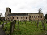 More images |
| Norham Castle | Norham, Northumberland | Keep and Bailey Castle | c. 1157 | 22 December 1969 | NT9064747607 55°43′18″N 2°09′02″W / 55.721789°N 2.150459°W / 55.721789; -2.150459 (Norham Castle) | 1154811 |  More images |
| Prior Castells Tower | Farne Islands, North Sunderland, Northumberland | Pele Tower | Earlier | 22 December 1969 | NU2178435996 55°37′01″N 1°39′21″W / 55.617072°N 1.6557°W / 55.617072; -1.6557 (Prior Castells Tower) | 1234461 | 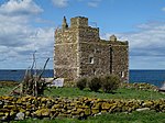 More images |
| Nunnykirk Hall | Nunnykirk, Northumberland | Country House | 1825 | 29 May 1987 | NZ0809692626 55°13′40″N 1°52′27″W / 55.227788°N 1.874263°W / 55.227788; -1.874263 (Nunnykirk Hall) | 1041251 | Upload Photo |
| Church of St Mary | Ovingham, Northumberland | Parish Church | 11th century | 15 April 1969 | NZ0849863707 54°58′04″N 1°52′08″W / 54.967916°N 1.868795°W / 54.967916; -1.868795 (Church of St Mary) | 1044940 |  More images |
| Church of St Mary | Ponteland, Northumberland | Parish Church | 12th to 15th century | 28 April 1969 | NZ1659072955 55°03′03″N 1°44′31″W / 55.050817°N 1.741868°W / 55.050817; -1.741868 (Church of St Mary) | 1370736 |  More images |
| Milbourne Hall and Stable Block | Ponteland, Northumberland | Country House | 1801 | 27 August 1952 | NZ1130874394 55°03′50″N 1°49′28″W / 55.063895°N 1.824485°W / 55.063895; -1.824485 (Milbourne Hall and Stable Block) | 1042725 |  More images |
| Prudhoe Castle | Prudhoe, Northumberland | Castle | 12th century | 12 June 1950 | NZ0916663408 54°57′55″N 1°51′30″W / 54.965217°N 1.85837°W / 54.965217; -1.85837 (Prudhoe Castle) | 1370476 |  More images |
| Beaufront Castle | Beaufront, Sandhoe, Northumberland | Country House | Late 17th century | 15 April 1969 | NY9639365942 54°59′17″N 2°03′28″W / 54.988056°N 2.057901°W / 54.988056; -2.057901 (Beaufront Castle) | 1043009 |  More images |
| Church of Our Lady | Seaton Valley, Northumberland | Parish Church | 18th or early 19th century | 28 July 1950 | NZ3218876416 55°04′52″N 1°29′50″W / 55.081155°N 1.497346°W / 55.081155; -1.497346 (Church of Our Lady) | 1041317 |  More images |
| Seaton Delaval Hall | Seaton Valley, Northumberland | Country House | 1718-29 | 28 July 1950 | NZ3224376528 55°04′56″N 1°29′47″W / 55.082157°N 1.496472°W / 55.082157; -1.496472 (Seaton Delaval Hall) | 1041321 | 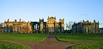 More images |
| Hopper Mausoleum north-east of St Andrew's Church, Shotley | Greymare Hill, Shotley Low Quarter, Northumberland | Mausoleum | 1663 | 15 April 1969 | NZ0453955212 54°53′30″N 1°55′51″W / 54.891628°N 1.930764°W / 54.891628; -1.930764 (Hopper Mausoleum north-east of St Andrew's Church, Shotley) | 1302881 |  More images |
| Hadrian's Wall, Milecastles and Turrets | Simonburn, Northumberland | Frontier Defence | 122 AD | 24 November 1967 | NY8181470532 55°01′44″N 2°17′10″W / 55.02898°N 2.286027°W / 55.02898; -2.286027 (Hadrian's Wall, Milecastles and Turrets) | 1045249 |  More images |
| Church of St Mary | Stamfordham, Northumberland | Parish Church | Saxon | 28 April 1969 | NZ0765372010 55°02′33″N 1°52′54″W / 55.042541°N 1.881775°W / 55.042541; -1.881775 (Church of St Mary) | 1370769 |  More images |
| Blagdon Hall | Blagdon, Stannington, Northumberland | House | Earlier | 27 August 1952 | NZ2156777043 55°05′14″N 1°39′49″W / 55.087361°N 1.663662°W / 55.087361; -1.663662 (Blagdon Hall) | 1042662 |  More images |
| Hadrian's Wall Milecastle and Turrets Hadrians Wall, Milecastle and Turrets | Thirlwall, Northumberland | Frontier Defence | 122 AD | 24 November 1967 | NY6383466245 54°59′22″N 2°34′00″W / 54.989472°N 2.566743°W / 54.989472; -2.566743 (Hadrian's Wall Milecastle and Turrets Hadrians Wall, Milecastle and Turrets) | 1178450 |  More images |
| Thirlwall Castle | Thirlwall, Northumberland | Castle | Mid-14th century | 24 November 1967 | NY6593966154 54°59′20″N 2°32′02″W / 54.988803°N 2.533836°W / 54.988803; -2.533836 (Thirlwall Castle) | 1302433 |  More images |
| Cocklaw Tower | Cocklaw, Wall, Northumberland | Tower House | 15 April 1969 | NY9392671154 55°02′06″N 2°05′48″W / 55.034868°N 2.096567°W / 55.034868; -2.096567 (Cocklaw Tower) | 1156641 |  More images | |
| Bridge over River Wansbeck | Wallington Demesne, Northumberland | Wall | 1755 | 20 October 1969 | NZ0335383910 55°08′58″N 1°56′56″W / 55.149521°N 1.948929°W / 55.149521; -1.948929 (Bridge over River Wansbeck) | 1303956 |  More images |
| Clock Tower Gate | Wallington Hall, Wallington Demesne, Northumberland | Gate | 1754 | 20 October 1969 | NZ0284184303 55°09′11″N 1°57′25″W / 55.153056°N 1.956959°W / 55.153056; -1.956959 (Clock Tower Gate) | 1042870 |  More images |
| Wallington Hall | Wallington Demesne, Northumberland | Country House | 1688 | 6 May 1952 | NZ0288084191 55°09′07″N 1°57′23″W / 55.152049°N 1.956348°W / 55.152049; -1.956348 (Wallington Hall) | 1042869 |  More images |
| Church of St Michael | Low Warden, Warden, Northumberland | Parish Church | Saxon | 15 April 1969 | NY9136166490 54°59′35″N 2°08′12″W / 54.992918°N 2.136556°W / 54.992918; -2.136556 (Church of St Michael) | 1044988 |  More images |
| Cross in Churchyard about 3m South of Tower of Church of St Michael | Low Warden, Warden, Northumberland | Cross | Early 7th century | 12 February 1985 | NY9134666484 54°59′34″N 2°08′12″W / 54.992864°N 2.13679°W / 54.992864; -2.13679 (Cross in Churchyard about 3m South of Tower of Church of St Michael) | 1155434 |  More images |
| Castle Curtain Walls with Gateway, Towers and attached Buildings | Warkworth Castle, Warkworth, Northumberland | Castle | 12th to 16th century | 31 December 1969 | NU2471905756 55°20′43″N 1°36′42″W / 55.345219°N 1.611781°W / 55.345219; -1.611781 (Castle Curtain Walls with Gateway, Towers and attached Buildings) | 1041690 |  More images |
| Church of St Lawrence | Warkworth, Northumberland | Sundial | Early Medieval | 31 December 1969 | NU2468706184 55°20′57″N 1°36′44″W / 55.349067°N 1.612248°W / 55.349067; -1.612248 (Church of St Lawrence) | 1303446 |  More images |
| The Donjon | Warkworth Castle, Warkworth, Northumberland | Kitchen | 13th century | 1 September 1988 | NU2472105816 55°20′45″N 1°36′42″W / 55.345758°N 1.611744°W / 55.345758; -1.611744 (The Donjon) | 1303256 | 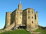 More images |
| Warkworth Hermitage | River Coquet, Warkworth, Northumberland | 31 December 1969 | NU2414605952 55°20′49″N 1°37′15″W / 55.347009°N 1.620799°W / 55.347009; -1.620799 (Warkworth Hermitage) | 1041684 |  More images | ||
| Church of St Mary Magdalene | Whalton, Northumberland | Parish Church | 11th century | 28 April 1969 | NZ1306681296 55°07′33″N 1°47′48″W / 55.125873°N 1.796646°W / 55.125873; -1.796646 (Church of St Mary Magdalene) | 1247805 |  More images |
| Ogle Castle | Ogle, Whalton, Northumberland | Castle | 29 April 1987 | NZ1405479077 55°06′21″N 1°46′53″W / 55.105907°N 1.781262°W / 55.105907; -1.781262 (Ogle Castle) | 1264065 |  More images | |
| Church of St Bartholomew | Whittingham, Northumberland | Church | 18th century | 21 October 1953 | NU0662811933 55°24′05″N 1°53′49″W / 55.401296°N 1.896894°W / 55.401296; -1.896894 (Church of St Bartholomew) | 1041257 |  More images |
| Halton Castle | Halton, Whittington, Northumberland | House | c. 1700 | 5 September 1985 | NY9971867841 55°00′18″N 2°00′21″W / 55.005135°N 2.005942°W / 55.005135; -2.005942 (Halton Castle) | 1155641 | 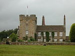 More images |
| Halton Church | Halton, Northumberland | Church | 12th century | 15 April 1969 | NY9976567829 55°00′18″N 2°00′19″W / 55.005027°N 2.005207°W / 55.005027; -2.005207 (Halton Church) | 1155675 |  More images |
| Church of the Holy Trinity | Widdrington, Northumberland | Parish Church | Late 12th century | 20 October 1969 | NZ2547995751 55°15′19″N 1°36′03″W / 55.255281°N 1.600701°W / 55.255281; -1.600701 (Church of the Holy Trinity) | 1371045 |  More images |
See also
- Category:Grade I listed buildings in Northumberland
- Grade II* listed buildings in Northumberland
Notes
- ^ The date given is the date used by Historic England as significant for the initial building or that of an important part in the structure's description.
- ^ Sometimes known as OSGB36, the grid reference is based on the British national grid reference system used by the Ordnance Survey.
- ^ The "List Entry Number" is a unique number assigned to each listed building and scheduled monument by Historic England.
References
National Heritage List for England
External links
![]() Media related to Grade I listed buildings in Northumberland at Wikimedia Commons
Media related to Grade I listed buildings in Northumberland at Wikimedia Commons
- v
- t
- e
- Bedfordshire
- Berkshire
- Bristol
- Buckinghamshire
- Cambridgeshire
- Cheshire
- Cornwall
- Cumbria
- Derbyshire
- Devon
- Dorset
- Durham
- East Sussex
- East Riding of Yorkshire
- Essex
- Gloucestershire
- Greater London
- Greater Manchester
- Hampshire
- Herefordshire
- Hertfordshire
- Isle of Wight
- Kent
- Lancashire
- Leicestershire
- Lincolnshire
- Merseyside
- Norfolk
- North Yorkshire
- Northamptonshire
- Northumberland
- Nottinghamshire
- Oxfordshire
- Rutland
- Shropshire
- Somerset
- South Yorkshire
- Staffordshire
- Suffolk
- Surrey
- Tyne and Wear
- Warwickshire
- West Midlands
- West Sussex
- West Yorkshire
- Wiltshire
- Worcestershire
- Babergh
- Bath and North East Somerset
- Bradford
- Brighton and Hove
- Broadland
- Cheltenham
- Cheshire East
- Cheshire West and Chester
- Cotswold
- Craven
- Dartford
- Dover
- Forest Heath
- Forest of Dean
- Ipswich
- Maidstone
- Mendip
- Mid Suffolk
- North Somerset
- Sedgemoor
- South Gloucestershire
- South Somerset
- St Edmundsbury
- Stroud
- Suffolk Coastal
- Taunton Deane
- Tewkesbury
- Waveney
- West Somerset
- Churches
- War memorials
- 20th century


