Grade II* listed buildings in Forest Heath
Map all coordinates using OpenStreetMap
Download coordinates as:
- KML
- GPX (all coordinates)
- GPX (primary coordinates)
- GPX (secondary coordinates)
There are over 20,000 Grade II* listed buildings in England. This page is a list of these buildings in the district of Forest Heath in Suffolk.
Forest Heath
| Name | Location | Type | Completed [note 1] | Date designated | Grid ref.[note 2] Geo-coordinates | Entry number [note 3] | Image |
|---|---|---|---|---|---|---|---|
| Church of St Mary | Barton Mills, Forest Heath | Church | Medieval | 7 May 1954 | TL7168973819 52°20′08″N 0°31′07″E / 52.335586°N 0.518505°E / 52.335586; 0.518505 (Church of St Mary) | 1351305 |  More images |
| Paradise Farmhouse | Barton Mills | Farmhouse | c. 1500 | 7 May 1954 | TL7232473847 52°20′08″N 0°31′40″E / 52.335638°N 0.52783°E / 52.335638; 0.52783 (Paradise Farmhouse) | 1037606 |  Upload Photo |
| Brandon Hall | Brandon | House | Late 17th century | 7 May 1954 | TL7704886166 52°26′41″N 0°36′13″E / 52.44477°N 0.603594°E / 52.44477; 0.603594 (Brandon Hall) | 1351338 | Upload Photo |
| Oak House | Brandon | House | c. 1730 | 7 May 1954 | TL7838286767 52°26′59″N 0°37′25″E / 52.449734°N 0.623521°E / 52.449734; 0.623521 (Oak House) | 1193522 | Upload Photo |
| Church of St Andrew | Cavenham | Church | Medieval | 7 May 1954 | TL7636069682 52°17′49″N 0°35′05″E / 52.296951°N 0.584822°E / 52.296951; 0.584822 (Church of St Andrew) | 1192820 |  More images |
| Lower Mill | Dalham | Smock Mill | c. 1790 | 7 May 1954 | TL7198261665 52°13′35″N 0°31′00″E / 52.226332°N 0.516607°E / 52.226332; 0.516607 (Lower Mill) | 1037666 |  More images |
| Church of St Andrew and St Patrick | Elveden | Church | Medieval | 7 May 1954 | TL8228379942 52°23′14″N 0°40′38″E / 52.387158°N 0.677141°E / 52.387158; 0.677141 (Church of St Andrew and St Patrick) | 1192876 |  More images |
| Elveden Hall | Elveden Park, Elveden | Country House | c. 1760 | 27 January 1972 | TL8246279720 52°23′06″N 0°40′47″E / 52.385104°N 0.679648°E / 52.385104; 0.679648 (Elveden Hall) | 1037611 | 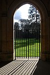 More images |
| Water Tower, 200 Metres South West of Elveden Hall | Elveden Park, Elveden | Water Tower | 1895 | 16 October 1984 | TL8226279612 52°23′03″N 0°40′36″E / 52.384201°N 0.676654°E / 52.384201; 0.676654 (Water Tower, 200 Metres South West of Elveden Hall) | 1192866 | Upload Photo |
| Church of St Laurence | Eriswell | Church | Medieval | 7 May 1954 | TL7236178019 52°22′23″N 0°31′50″E / 52.373097°N 0.530513°E / 52.373097; 0.530513 (Church of St Laurence) | 1037596 |  More images |
| Church of St Nicholas | Landwade, Exning | Church | c. 1445 | 19 August 1959 | TL6232568098 52°17′13″N 0°22′42″E / 52.287045°N 0.378443°E / 52.287045; 0.378443 (Church of St Nicholas) | 1162203 | 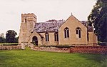 More images |
| Glanelly Rest (Exning House) including two attached Gate Ways and Section of Garden Wall to North | Exning | Country House | 1734 | 25 January 1963 | TL6224465982 52°16′05″N 0°22′34″E / 52.268062°N 0.376239°E / 52.268062; 0.376239 (Glanelly Rest (Exning House) including two attached Gate Ways and Section of Garden Wall to North) | 1374829 | Upload Photo |
| Church of St Andrew | Freckenham | Church | Medieval | 7 May 1954 | TL6659771758 52°19′07″N 0°26′34″E / 52.318642°N 0.442823°E / 52.318642; 0.442823 (Church of St Andrew) | 1037614 |  More images |
| Manor House | Freckenham | House | Late 17th century | 16 October 1984 | TL6674771807 52°19′09″N 0°26′42″E / 52.319037°N 0.445046°E / 52.319037; 0.445046 (Manor House) | 1037615 | Upload Photo |
| Church of St Ethelbert | Herringswell | Church | Medieval | 7 May 1954 | TL7180669953 52°18′03″N 0°31′06″E / 52.300826°N 0.518248°E / 52.300826; 0.518248 (Church of St Ethelbert) | 1351310 | 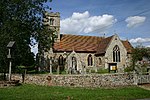 More images |
| Church of St James | Icklingham | Church | Medieval | 7 May 1954 | TL7704873049 52°19′37″N 0°35′48″E / 52.326968°N 0.596669°E / 52.326968; 0.596669 (Church of St James) | 1037582 |  More images |
| Church of St Mary | Kentford | Church | Earlier | 7 May 1954 | TL7065466795 52°16′22″N 0°29′59″E / 52.272821°N 0.499773°E / 52.272821; 0.499773 (Church of St Mary) | 1037677 | 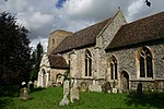 More images |
| Pack Horse Bridge over the River Kennet | Moulton | Packhorse Bridge | Early 15th century | 7 May 1954 | TL6975964531 52°15′10″N 0°29′08″E / 52.252763°N 0.485531°E / 52.252763; 0.485531 (Pack Horse Bridge over the River Kennet) | 1037678 |  More images |
| Church of St Agnes | Newmarket | Church | 1886 | 26 June 1984 | TL6501764006 52°14′58″N 0°24′57″E / 52.249489°N 0.415873°E / 52.249489; 0.415873 (Church of St Agnes) | 1037643 |  More images |
| Church of St Mary | Newmarket | Church | Medieval | 28 November 1950 | TL6412563419 52°14′40″N 0°24′09″E / 52.244483°N 0.402534°E / 52.244483; 0.402534 (Church of St Mary) | 1037636 |  More images |
| Cleveland House | Newmarket | House | c. 1730 | 10 March 1970 | TL6483763476 52°14′41″N 0°24′47″E / 52.244782°N 0.41298°E / 52.244782; 0.41298 (Cleveland House) | 1351318 | Upload Photo |
| Palace Mansion and Entrance Steps | Newmarket | House | Early to Mid 19th century | 26 June 1984 | TL6443363358 52°14′38″N 0°24′25″E / 52.243843°N 0.407011°E / 52.243843; 0.407011 (Palace Mansion and Entrance Steps) | 1285676 | Upload Photo |
| Church of St Denis | Wangford | Church | Medieval | 7 May 1954 | TL7508083513 52°25′18″N 0°34′24″E / 52.421577°N 0.573281°E / 52.421577; 0.573281 (Church of St Denis) | 1037542 | 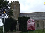 More images |
| Elveden War Memorial | Elveden | War memorial | 1921 | 7 May 1954 | TL7880177624 52°22′03″N 0°37′29″E / 52.367488°N 0.62479848°E / 52.367488; 0.62479848 (Elveden War Memorial) | 1037610 |  More images |
Notes
- ^ The date given is the date used by Historic England as significant for the initial building or that of an important part in the structure's description.
- ^ Sometimes known as OSGB36, the grid reference is based on the British national grid reference system used by the Ordnance Survey.
- ^ The "List Entry Number" is a unique number assigned to each listed building and scheduled monument by Historic England.
External links
![]() Media related to Grade II* listed buildings in Forest Heath at Wikimedia Commons
Media related to Grade II* listed buildings in Forest Heath at Wikimedia Commons
- v
- t
- e
- Bedfordshire
- Berkshire
- Bristol
- Buckinghamshire
- Cambridgeshire
- Cheshire
- Cornwall
- Cumbria
- Derbyshire
- Devon
- Dorset
- Durham
- East Sussex
- East Riding of Yorkshire
- Essex
- Gloucestershire
- Greater London
- Greater Manchester
- Hampshire
- Herefordshire
- Hertfordshire
- Isle of Wight
- Kent
- Lancashire
- Leicestershire
- Lincolnshire
- Merseyside
- Norfolk
- North Yorkshire
- Northamptonshire
- Northumberland
- Nottinghamshire
- Oxfordshire
- Rutland
- Shropshire
- Somerset
- South Yorkshire
- Staffordshire
- Suffolk
- Surrey
- Tyne and Wear
- Warwickshire
- West Midlands
- West Sussex
- West Yorkshire
- Wiltshire
- Worcestershire
- Allerdale
- Amber Valley
- Ashford
- Babergh
- Barrow-in-Furness
- Basildon
- Basingstoke and Deane
- Bath and North East Somerset
- Bolsover
- Boston
- Bournemouth
- Bradford
- Braintree
- Breckland
- Brentwood
- Brighton and Hove
- Bristol
- Broadland
- Calderdale
- Cambridge
- Camden
- Canterbury
- Carlisle
- Castle Point
- Chelmsford
- Cheltenham
- Cherwell
- Cheshire East
- Cheshire West and Chester
- Chesterfield
- Chiltern
- Christchurch
- Colchester
- Copeland
- Corby
- Cotswold
- Dartford
- Daventry
- Dover
- East Cambridgeshire
- Exeter
- Mendip
- North Somerset
- North Yorkshire (district)
- Poole
- Sedgemoor
- South Somerset
- Stoke-on-Trent
- Taunton Deane
- West Somerset
- York


