Beit Șe'an
| Deși acest articol conține o listă de referințe bibliografice, sursele sale rămân neclare deoarece îi lipsesc notele de subsol. Puteți ajuta introducând citări mai precise ale surselor. |
| Beit Șe'an | |||
| בית שאן | |||
| — oraș și așezare umană — | |||
 Vedere a orașului dinspre vest | |||
| |||
  Beit Șe'an Beit Șe'an (Israel) | |||
| Coordonate: 32°29′N 35°29′E ({{PAGENAME}}) / 32.483°N 35.483°E | |||
|---|---|---|---|
| Țară |  Israel Israel | ||
| District | Nord | ||
| Fondare | 1949 | ||
| Guvernare | |||
| - Primar | Jacky Levi | ||
| Suprafață | |||
| - Oraș | 7,33 km² | ||
| Altitudine | −125 m.d.m. | ||
| Populație (2011) | |||
| - Oraș | 16.922 locuitori | ||
| - Densitate | 2.308,9 loc./km² | ||
| Fus orar | EET (+2) | ||
| - Ora de vară (DST) | EEST (+3) | ||
| Cod poștal | 19150 | ||
| Localități înfrățite | |||
| - Cleveland | Statele Unite ale Americii | ||
| - Tarascon | Franța | ||
| Prezență online | |||
site web oficial  | |||
Modifică date / text  | |||

Beit Șe'an (în ebraică בית שאן, în arabă: - بيسان) este un oraș din nordul Israelului, situat în Valea Beit Shean, în apropierea Văii Iordanului, la 25 km sud-vest de Marea Galileei.
Localitate cu o mare vechime, a fost locuită fără întrerupere din perioada calcolitică (circa 4000 î.e.n.) și până în zilele noastre. Ea s-a numit pe parcursul istoriei Ashan, Beit Shan, Beyshan, Skythopolis și Baysan. S-a numit, după câte se pare, după zeul Shan, căruia locuitorii antici i-au închinat aici un templu.[1] Beit Shean este centrul unei zone administrative numită Consiliul regional al Văii Beit Shean, care a fost constituită în iunie 1949. Majoritatea locuitorilor arabi a abandonat orașul înaintea luptelor din Războiul arabo-israelian din 1948-1949. O mica parte care rămăsese a fost evacuat după terminarea luptelor, mai ales spre Nazaret. Localitatea se întinde pe o arie de 7.1 kmp, iar populația lui este de circa 17.300 locuitori.(2013). Beit Shean a fost proclamat oraș în anul 1999.
Istorie
În oraș este situat parcul național Scitopolis, care a fost în antichitate unul din orașele componente ale Decapolis (zece orașe elenistice, unite într-o unitate administrativă separată la frontiera de est a Imperiului Roman unite datorită limbii, culturii, locației și statutului politic comun). Orașul a fost distrus de un incendiu în secolul al II-lea.[2]
Galerie
-
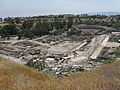 Anticul Beit Șe'an - Skythopolis
 -
 Teatrul roman
 -
 Ruinele teatrului roman
 -

-
-
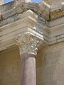
 Capitel de coloana corintică
 -

-
 Drumul roman Paladius
 -
 Colonada de pe strada de nord din Scythopolis
 -
 Coloană distrusă


Orașe înfrățite

Note
Bibliografie
- Barron, J. B., ed. (). Palestine: Report and General Abstracts of the Census of 1922. Government of Palestine.
- Conder, C.R.; Kitchener, H.H. (). The Survey of Western Palestine: Memoirs of the Topography, Orography, Hydrography, and Archaeology. 2. London: Committee of the Palestine Exploration Fund. (Conder and Kitchener, 1882, SWP II, p. 83)
- Dauphin, Claudine (). La Palestine byzantine, Peuplement et Populations. BAR International Series 726 (în French). III : Catalogue. Oxford: Archeopress. ISBN 0-860549-05-4. Mentenanță CS1: Limbă nerecunoscută (link) (p.782)
- Department of Statistics (). Village Statistics, April, 1945. Government of Palestine. (Department of Statistics, 1945, p. 6)
- Guérin, V. (). Description Géographique Historique et Archéologique de la Palestine (în French). 2: Samarie, pt. 1. Paris: L'Imprimerie Nationale. Mentenanță CS1: Limbă nerecunoscută (link) (284- 298)
- Hadawi, S. (). Village Statistics of 1945: A Classification of Land and Area ownership in Palestine. Palestine Liberation Organization Research Centre. (pp. 43, 84134)
- Hütteroth, Wolf-Dieter; Abdulfattah, Kamal (). Historical Geography of Palestine, Transjordan and Southern Syria in the Late 16th Century. Erlanger Geographische Arbeiten, Sonderband 5. Erlangen, Germany: Vorstand der Fränkischen Geographischen Gesellschaft. ISBN 3-920405-41-2. (p.168)
- Le Strange, G. (). Palestine Under the Moslems: A Description of Syria and the Holy Land from A.D. 650 to 1500. Committee of the Palestine Exploration Fund.
- Meyers, E. M.; Chancey, Mark A. (). Alexander to Constantine: Archaeology of the Land of the Bible, Volume III. Yale University Press. ISBN 978-0-300-14179-5.
- Mills, E., ed. (). Census of Palestine 1931. Population of Villages, Towns and Administrative Areas. Jerusalem: Government of Palestine.
- Morris, B. (). The Birth of the Palestinian Refugee Problem Revisited. Cambridge University Press. ISBN 978-0-521-00967-6.
- Shahin, Mariam (). Palestine: A Guide
 . Interlink Books. pp. 159–165. ISBN 1-56656-557-X.
 - Sharon, M. (). Corpus Inscriptionum Arabicarum Palaestinae, B-C. 2. Brill. ISBN 90-04-11083-6. (see p.195 ff)

- Tsafrir, Y. and Foerster, Gideon: "“Nysa-Scythopolis – A New Inscription and the Titles of the City on its Coins", The Israel Numismatic Journal. Vol. 9, 1986–7, pp. 53–58.
- Tsafrir, Y. and Foerster, Gideon: "Bet Shean Excavation Project – 1988/1989", Excavations and Surveys in Israel 1989/1990. Volume 9. Israel Antiquities Authority. Numbers 94–95. Jerusalem 1989/1990, pp. 120–128.
- Tsafrir, Y. and Foerster, Gideon: "From Scythopolis to Baisān: Changes in the perception of the city of Bet Shean during the Byzantine and Arab Eras", Cathedra. For the History of Eretz Israel and its Yishuv, 64. Yad Izhak Ben-Zvi. Jerusalem, July 1992 (in Hebrew).
- Tsafrir, Y. and Foerster, Gideon: "The Dating of the 'Earthquake of the Sabbatical Year of 749 C. E.' in Palestine", Bulletin of the School of Oriental and African Studies of London. Vol. LV, Part 2. London 1992, pp. 231–235.
- Tsafrir, Y. and Foerster, Gideon: "Urbanism at Scythopolis-Bet Shean in the Fourth to Seventh Centuries", Dumbarton Oaks Papers. Dumbarton Oaks Research Library and Collection. Number Fifty-One, 1997. pp. 85–146.
Legături externe
![]() Materiale media legate de Beit Șe'an la Wikimedia Commons
Materiale media legate de Beit Șe'an la Wikimedia Commons
- Beit She'an National Park – official site
- BET(H)-SHEAN Jewish Virtual Library
- Ilan Phahima and Yoram Saad, Scythopolis: Conservation of the Roman Bridge, Israel Antiquities Authority Site – Conservation Department
- Survey of Western Palestine, 1880 Map of Beit Shean (Beisân), Map 9: IAA, Wikimedia commons
- Air photo map of Beisan, 1945. Eran Laor Cartographic Collection, The National Library of Israel.
- Map of Beisan, 1929. Survey of Palestine. Eran Laor Cartographic Collection, The National Library of Israel.
| ||
|---|---|---|
| Iordania |
|  |
| Siria |
| |
| Israel |
| |
| Control de autoritate |
|
|---|


