WR postcode area
Postcode area within the United Kingdom
52°10′01″N 2°11′17″W / 52.167°N 2.188°W / 52.167; -2.188WR
Worcester
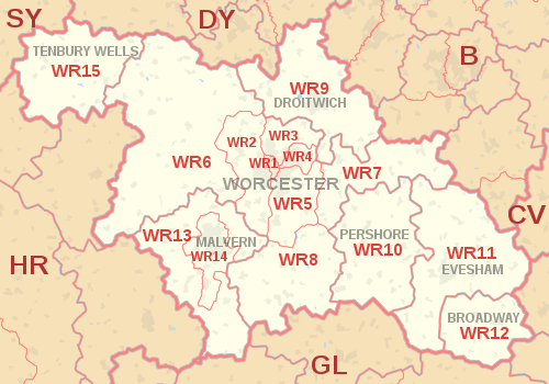
The WR postcode area, also known as the Worcester postcode area,[2] is a group of fifteen postcode districts in England, within seven post towns. These cover central and southern Worcestershire (including Worcester, Broadway, Droitwich, Evesham, Malvern, Pershore and Tenbury Wells), plus very small parts of Herefordshire, Shropshire, Warwickshire and Gloucestershire.
Coverage
The approximate coverage of the postcode districts:
| Postcode district | Post town | Coverage | Local authority area(s) |
|---|---|---|---|
| WR1 | WORCESTER | Worcester | Worcester |
| WR2 | WORCESTER | Powick, Hallow | Worcester, Malvern Hills |
| WR3 | WORCESTER | Fernhill Heath, Claines | Worcester, Wychavon |
| WR4 | WORCESTER | Warndon, Long Meadow | Worcester, Wychavon |
| WR5 | WORCESTER | Kempsey, Broomhall | Worcester, Wychavon, Malvern Hills |
| WR6 | WORCESTER | Martley, Clifton on Teme, Abberley | Malvern Hills, Herefordshire |
| WR7 | WORCESTER | Inkberrow, Crowle, Upton Snodsbury | Wychavon |
| WR8 | WORCESTER | Upton upon Severn, Hanley Castle, Hanley Swan | Malvern Hills, Wychavon |
| WR9 | DROITWICH | Droitwich, Ombersley, Wychbold, Rushock | Wychavon, Wyre Forest |
| WR10 | PERSHORE | Pershore, Eckington, Drakes Broughton | Wychavon |
| WR11 | BROADWAY | non-geographic[3] | |
| WR11 | EVESHAM | Evesham, Harvington, Badsey, Sedgeberrow, Ashton under Hill | Wychavon, Stratford-on-Avon, Tewkesbury, Cotswold |
| WR12 | BROADWAY | Broadway, Willersey, Childswickham | Wychavon, Tewkesbury, Cotswold |
| WR13 | MALVERN | Colwall, Cradley, Welland | Malvern Hills, Herefordshire, Forest of Dean |
| WR14 | MALVERN | Malvern, Upper Welland | Malvern Hills, Herefordshire |
| WR15 | TENBURY WELLS | Tenbury Wells, Burford, Newnham Bridge, Bockleton | Malvern Hills, Shropshire, Herefordshire |
| WR78 | WORCESTER | Kays Ltd | non-geographic[4] |
| WR99 | WORCESTER | Kays Ltd | non-geographic[4] |
Map
KML file (edit • help)
Template:Attached KML/WR postcode area
KML is from Wikidata
See also
References
- ^ "ONS Postcode Directory Version Notes" (ZIP). National Statistics Postcode Products. Office for National Statistics. May 2020. Table 2. Retrieved 19 June 2020. Coordinates from mean of unit postcode points, "Code-Point Open". OS OpenData. Ordnance Survey. February 2012. Retrieved 21 April 2012.
- ^ Royal Mail, Address Management Guide, (2004)
- ^ "New sectors and localities to 16 November 2012" (PDF). Royal Mail Address Management Unit. 19 November 2012. Retrieved 29 November 2012.
- ^ a b "Non Geographic Codes" (PDF). Royal Mail Address Management Unit. July 2012. Archived from the original (PDF) on 16 September 2012. Retrieved 29 November 2012.
External links
- Royal Mail's Postcode Address File
- A quick introduction to Royal Mail's Postcode Address File (PAF)
- v
- t
- e
- AB
- AL
- B
- BA
- BB
- BD
- BH
- BL
- BN
- BR
- BS
- BT
- CA
- CB
- CF
- CH
- CM
- CO
- CR
- CT
- CV
- CW
- DA
- DD
- DE
- DG
- DH
- DL
- DN
- DT
- DY
- E
- EC
- EH
- EN
- EX
- FK
- FY
- G
- GL
- GU
- HA
- HD
- HG
- HP
- HR
- HS
- HU
- HX
- IG
- IP
- IV
- KA
- KT
- KW
- KY
- L
- LA
- LD
- LE
- LL
- LN
- LS
- LU
- M
- ME
- MK
- ML
- N
- NE
- NG
- NN
- NP
- NR
- NW
- OL
- OX
- PA
- PE
- PH
- PL
- PO
- PR
- RG
- RH
- RM
- S
- SA
- SE
- SG
- SK
- SL
- SM
- SN
- SO
- SP
- SR
- SS
- ST
- SW
- SY
- TA
- TD
- TF
- TN
- TQ
- TR
- TS
- TW
- UB
- W
- WA
- WC
- WD
- WF
- WN
- WR
- WS
- WV
- YO
- ZE
- Related UK lists: Postcode districts
- Post towns
- Postal counties
- London postal district


