TF postcode area
Postcode area within the United Kingdom
52°43′01″N 2°27′40″W / 52.717°N 2.461°W / 52.717; -2.461
TF
Telford
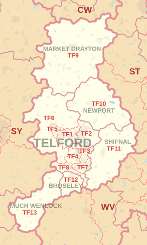
The TF postcode area, also known as the Telford postcode area,[2] is a group of thirteen postcode districts in England, within six post towns. These cover north-east Shropshire, including Telford, Broseley, Market Drayton, Much Wenlock, Newport and Shifnal, plus a small part of west Staffordshire.
Coverage
The approximate coverage of the postcode districts:
| Postcode district | Post town | Coverage | Local authority area(s) |
|---|---|---|---|
| TF1 | TELFORD | Wellington, Leegomery, Hadley, Ketley, Arleston, Hortonwood | Telford & Wrekin |
| TF2 | TELFORD | Oakengates, Priorslee, St. Georges, Donnington, Wrockwardine Wood, Muxton | Telford & Wrekin |
| TF3 | TELFORD | Telford Town Centre and Park, Hollinswood, Randlay, Stirchley, Brookside, Stafford Park | Telford & Wrekin |
| TF4 | TELFORD | Dawley, Malinslee, Lawley, Horsehay | Telford & Wrekin |
| TF5 | TELFORD | Admaston, Bratton, Shawbirch | Telford & Wrekin |
| TF6 | TELFORD | The Wrekin, Wrockwardine, Longden-upon-Tern, High Ercall | Telford & Wrekin |
| TF7 | TELFORD | Madeley, Woodside, Sutton Hill, Halesfield | Telford & Wrekin |
| TF8 | TELFORD | Ironbridge, Coalbrookdale, Coalport, Jackfield | Telford & Wrekin |
| TF9 | MARKET DRAYTON | Market Drayton, Loggerheads, Hodnet, Ternhill | Shropshire, Newcastle-under-Lyme |
| TF10 | NEWPORT | Newport, Lilleshall, Edgmond, Moreton, Great Chatwell, Orslow | Telford & Wrekin, Stafford, South Staffordshire |
| TF11 | SHIFNAL | Shifnal, Tong, Weston-under-Lizard | Shropshire, South Staffordshire |
| TF12 | BROSELEY | Broseley | Shropshire |
| TF13 | MUCH WENLOCK | Much Wenlock | Shropshire |
Map
KML file (edit • help)
Template:Attached KML/TF postcode area
KML is from Wikidata
See also
References
- ^ "ONS Postcode Directory Version Notes" (ZIP). National Statistics Postcode Products. Office for National Statistics. May 2020. Table 2. Retrieved 19 June 2020. Coordinates from mean of unit postcode points, "Code-Point Open". OS OpenData. Ordnance Survey. February 2012. Retrieved 21 April 2012.
- ^ Royal Mail, Address Management Guide, (2004)
External links
- Royal Mail's Postcode Address File
- A quick introduction to Royal Mail's Postcode Address File (PAF)
- Using Welsh alternative addresses within Royal Mail's Postcode Address File (PAF)
- v
- t
- e
- AB
- AL
- B
- BA
- BB
- BD
- BH
- BL
- BN
- BR
- BS
- BT
- CA
- CB
- CF
- CH
- CM
- CO
- CR
- CT
- CV
- CW
- DA
- DD
- DE
- DG
- DH
- DL
- DN
- DT
- DY
- E
- EC
- EH
- EN
- EX
- FK
- FY
- G
- GL
- GU
- HA
- HD
- HG
- HP
- HR
- HS
- HU
- HX
- IG
- IP
- IV
- KA
- KT
- KW
- KY
- L
- LA
- LD
- LE
- LL
- LN
- LS
- LU
- M
- ME
- MK
- ML
- N
- NE
- NG
- NN
- NP
- NR
- NW
- OL
- OX
- PA
- PE
- PH
- PL
- PO
- PR
- RG
- RH
- RM
- S
- SA
- SE
- SG
- SK
- SL
- SM
- SN
- SO
- SP
- SR
- SS
- ST
- SW
- SY
- TA
- TD
- TF
- TN
- TQ
- TR
- TS
- TW
- UB
- W
- WA
- WC
- WD
- WF
- WN
- WR
- WS
- WV
- YO
- ZE
- Related UK lists: Postcode districts
- Post towns
- Postal counties
- London postal district


