Grade I and II* listed buildings in the London Borough of Hillingdon
Map all coordinates using OpenStreetMap
Download coordinates as:
- KML
- GPX (all coordinates)
- GPX (primary coordinates)
- GPX (secondary coordinates)
There are over 9,000 Grade I listed buildings and 20,000 Grade II* listed buildings in England. This page is a list of these buildings in the London Borough of Hillingdon.
Grade I
| Name | Location | Type | Completed [note 1] | Date designated | Grid ref.[note 2] Geo-coordinates | Entry number [note 3] | Image |
|---|---|---|---|---|---|---|---|
| Breakspear House | Harefield, Hillingdon | House | Early-mid 17th century | 8 May 1950 | TQ0607989641 51°35′44″N 0°28′12″W / 51.595637°N 0.469956°W / 51.595637; -0.469956 (Breakspear House) | 1080262 | 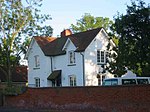 More images |
| Church of St Martin of Tours | Ruislip, Hillingdon | Parish Church | Mid 13th century | 24 January 1950 | TQ0915387604 51°34′36″N 0°25′34″W / 51.576742°N 0.426228°W / 51.576742; -0.426228 (Church of St Martin of Tours) | 1285697 |  More images |
| Church of St Mary | Harefield, Hillingdon | Parish Church | 12th century | 8 May 1950 | TQ0533389586 51°35′43″N 0°28′51″W / 51.595283°N 0.480739°W / 51.595283; -0.480739 (Church of St Mary) | 1358363 | 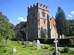 More images |
| Church of St Peter and St Paul | Harlington, Hillingdon | Parish Church | 12th century | 27 May 1949 | TQ0880078214 51°29′33″N 0°26′03″W / 51.492413°N 0.434219°W / 51.492413; -0.434219 (Church of St Peter and St Paul) | 1080163 | 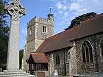 More images |
| Group Operations Room | RAF Uxbridge, Hillingdon | Underground Military Headquarters | 1938–1939 | 1 December 2005 | TQ0654883514 51°32′26″N 0°27′54″W / 51.540479°N 0.465044°W / 51.540479; -0.465044 (Group Operations Room) | 1392556 |  More images |
| Ickenham Manor | Ickenham, Hillingdon | Hall House | LATE MEDIEVAL | 8 May 1950 | TQ0829385329 51°33′23″N 0°26′22″W / 51.55646°N 0.439334°W / 51.55646; -0.439334 (Ickenham Manor) | 1080187 |  Upload Photo |
| Manor Farm Barn (to West of Church of St Mary) | Harmondsworth, Hillingdon | Tithe Barn | LATE MEDIEVAL | 1 March 1950 | TQ0563277848 51°29′23″N 0°28′48″W / 51.489723°N 0.479943°W / 51.489723; -0.479943 (Manor Farm Barn (to West of Church of St Mary)) | 1194332 |  More images |
| Outbuildings to North of Swakeleys | Ickenham, Hillingdon | Courtyard | 6 September 1974 | TQ0742885753 51°33′38″N 0°27′06″W / 51.560436°N 0.451677°W / 51.560436; -0.451677 (Outbuildings to North of Swakeleys) | 1286571 |  | |
| Swakeleys | Ickenham, Hillingdon | House | 1629–1638 | 1 May 1956 | TQ0742185706 51°33′36″N 0°27′06″W / 51.560015°N 0.451792°W / 51.560015; -0.451792 (Swakeleys) | 1080295 | 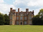 More images |
Grade II*
| Name | Location | Type | Completed [note 1] | Date designated | Grid ref.[note 2] Geo-coordinates | Entry number [note 3] | Image |
|---|---|---|---|---|---|---|---|
| Almshouses | Harefield, Hillingdon | Almshouse | 16th century | 8 May 1950 | TQ0515689824 51°35′51″N 0°29′00″W / 51.597455°N 0.483222°W / 51.597455; -0.483222 (Almshouses) | 1358364 | 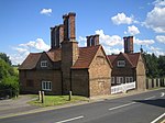 |
| Cedars House | Hillingdon, Hillingdon | House | c. 1580 | 8 May 1950 | TQ0694883003 51°32′09″N 0°27′34″W / 51.53581°N 0.459434°W / 51.53581; -0.459434 (Cedars House) | 1284903 | Upload Photo |
| Church of St Dunstan | Cranford, Hillingdon | Church | 13th century | 27 May 1949 | TQ1016078179 51°29′31″N 0°24′53″W / 51.491835°N 0.414648°W / 51.491835; -0.414648 (Church of St Dunstan) | 1181190 |  More images |
| Church of St Giles | Ickenham, Hillingdon | Parish Church | Late 14th century | 8 May 1950 | TQ0795086264 51°33′54″N 0°26′38″W / 51.56493°N 0.443993°W / 51.56493; -0.443993 (Church of St Giles) | 1080229 |  More images |
| Church of St John | Hillingdon, Hillingdon | Parish Church | 13th century | 8 May 1950 | TQ0691482916 51°32′06″N 0°27′36″W / 51.535035°N 0.45995°W / 51.535035; -0.45995 (Church of St John) | 1080160 | 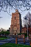 More images |
| Church of St Laurence | Cowley, Hillingdon | Parish Church | 12th century | 8 May 1950 | TQ0599482043 51°31′38″N 0°28′24″W / 51.527361°N 0.473471°W / 51.527361; -0.473471 (Church of St Laurence) | 1286371 | 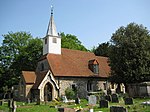 More images |
| Church of St Margaret | Uxbridge | 14th-15th century | 1985–88 | 8 May 1950 | TQ0552584099 51°32′45″N 0°28′47″W / 51.545929°N 0.479614°W / 51.545929; -0.479614 (Church of St Margaret) | 1180516 | 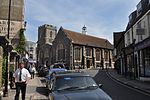 More images |
| Church of St Martin | West Drayton, Hillingdon | Parish Church | 13th century | 1 March 1950 | TQ0616379542 51°30′17″N 0°28′18″W / 51.50485°N 0.471789°W / 51.50485; -0.471789 (Church of St Martin) | 1358325 |  More images |
| Church of St Mary | Hayes, Hillingdon | Parish Church | 13th century | 27 May 1949 | TQ0970881077 51°31′05″N 0°25′13″W / 51.51797°N 0.420256°W / 51.51797; -0.420256 (Church of St Mary) | 1080233 |  More images |
| Church of St Mary, Harmondsworth | Harmondsworth, Hillingdon | Parish Church | 12th century | 1 March 1950 | TQ0569577808 51°29′22″N 0°28′45″W / 51.489352°N 0.479048°W / 51.489352; -0.479048 (Church of St Mary, Harmondsworth) | 1080201 | 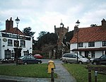 More images |
| Regal Cinema, Uxbridge | Hillingdon | Cinema | 1930–31 | 15 November 1976 | TQ0589583954 51°32′40″N 0°28′28″W / 51.544556°N 0.474324°W / 51.544556; -0.474324 (Regal Cinema, Uxbridge) | 1080111 | 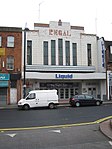 More images |
| Dovecote to North West of Breakspear House | Harefield, Hillingdon | Dovecote | 17th century | 4 July 1968 | TQ0601689692 51°35′46″N 0°28′15″W / 51.596108°N 0.47085°W / 51.596108; -0.47085 (Dovecote to North West of Breakspear House) | 1080263 | Upload Photo |
| Footbridge Across River Colne, to North of Denham Court | Denham Court, Hillingdon | Footbridge | c. 1850 | 30 June 1986 | TQ0515587329 51°34′30″N 0°29′02″W / 51.57503°N 0.483983°W / 51.57503; -0.483983 (Footbridge Across River Colne, to North of Denham Court) | 1065962 | Upload Photo |
| Fray's Cottage Old Mill House | West Drayton, Hillingdon | House | Late 18th century | 1 March 1950 | TQ0542979082 51°30′03″N 0°28′57″W / 51.500852°N 0.482498°W / 51.500852; -0.482498 (Fray's Cottage Old Mill House) | 1181607 | 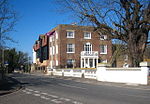 More images |
| Great Barn to West of Manor Farm Yard | Ruislip | Barn | Late 17th century or 18th century | 6 September 1974 | TQ0897787755 51°34′41″N 0°25′43″W / 51.578133°N 0.42872°W / 51.578133; -0.42872 (Great Barn to West of Manor Farm Yard) | 1358359 |  More images |
| Green End | Northwood, Hillingdon | House | 17th century | 14 September 1993 | TQ0895391704 51°36′49″N 0°25′40″W / 51.613631°N 0.427841°W / 51.613631; -0.427841 (Green End) | 1065964 | Upload Photo |
| Harefield Park | Harefield, Hillingdon | House | EARLY-MID 18th century | 6 September 1974 | TQ0493390841 51°36′24″N 0°29′10″W / 51.606637°N 0.486136°W / 51.606637; -0.486136 (Harefield Park) | 1080177 | 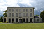 More images |
| Heinz buildings | Hayes, Hillingdon | Commercial Office: full name: Heinz Administrative Headquarters and Former Research Laboratories | Mid 20th century | 24 November 1995 | TQ0887582471 51°31′50″N 0°25′55″W / 51.530661°N 0.431826°W / 51.530661; -0.431826 (Heinz buildings) | 1242724 | 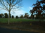 |
| Hillingdon Court | Hillingdon, Hillingdon | Country House | 1854-8 | 16 August 1983 | TQ0684883829 51°32′36″N 0°27′38″W / 51.543253°N 0.460624°W / 51.543253; -0.460624 (Hillingdon Court) | 1080114 | Upload Photo |
| Mount Vernon Hospital Chapel | Northwood | Chapel | 1904 | 6 September 1974 | TQ0785991779 51°36′52″N 0°26′37″W / 51.614516°N 0.443612°W / 51.614516; -0.443612 (Mount Vernon Hospital Chapel) | 1358386 | Upload Photo |
| No. 9-15 High Street | Ruislip | Continuous Jetty House | 16th century | 24 January 1950 | TQ0912487593 51°34′36″N 0°25′36″W / 51.576649°N 0.42665°W / 51.576649; -0.42665 (No. 9-15 High Street) | 1080204 | 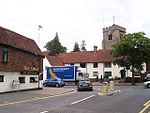 |
| Southlands | West Drayton, Hillingdon | House | Early 18th century | 1 March 1950 | TQ0588779170 51°30′06″N 0°28′33″W / 51.501558°N 0.475875°W / 51.501558; -0.475875 (Southlands) | 1286038 |  More images |
| Crown and Treaty Inn | Uxbridge | Inn | 1576 | 8 May 1950 | TQ0519884529 51°32′59″N 0°29′03″W / 51.549855°N 0.4842°W / 51.549855; -0.4842 (Crown and Treaty Inn) | 1080148 | 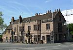 More images |
| The Frays | West Drayton, Hillingdon | House | Late 16th century | 6 September 1974 | TQ0554679319 51°30′11″N 0°28′51″W / 51.502961°N 0.480742°W / 51.502961; -0.480742 (The Frays) | 1358349 | Upload Photo |
| The Market House | Uxbridge | Market House | 1788 | 8 May 1950 | TQ0553784107 51°32′46″N 0°28′46″W / 51.545998°N 0.479439°W / 51.545998; -0.479439 (The Market House) | 1080208 |  More images |
| The Old Gatehouse | West Drayton, Hillingdon | Manor House | Early 16th century | 1 March 1950 | TQ0617179491 51°30′16″N 0°28′18″W / 51.50439°N 0.471689°W / 51.50439; -0.471689 (The Old Gatehouse) | 1193001 |  More images |
| Walls south of Old Gatehouse etc. | West Drayton, Hillingdon: full name: Wall Running South from the Old Gatehouse and West Along Front of Gatehouse Nurseries | Wall | Early 16th century | 6 September 1974 | TQ0615579469 51°30′15″N 0°28′19″W / 51.504195°N 0.471926°W / 51.504195; -0.471926 (Walls south of Old Gatehouse etc.) | 1358326 | |
| Walls around St Martin's | West Drayton, Hillingdon | Wall: full name: Walls Around Saint Martin's Churchyard | 16th century | 6 September 1974 | TQ0618579549 51°30′18″N 0°28′17″W / 51.504909°N 0.47147°W / 51.504909; -0.47147 (Walls around St Martin's) | 1286366 | 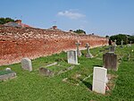 More images |
| Walls of Cooombe House | West Drayton, Hillingdon: full name: Walls to East and South of Garden of Number 28 (coombe House) | Wall | Early 16th century | 6 September 1974 | TQ0609579466 51°30′15″N 0°28′22″W / 51.504179°N 0.472791°W / 51.504179; -0.472791 (Walls of Cooombe House) | 1193014 |  |
See also
Notes
- ^ a b The date given is the date used by Historic England as significant for the initial building or that of an important part in the structure's description.
- ^ a b Sometimes known as OSGB36, the grid reference is based on the British national grid reference system used by the Ordnance Survey.
- ^ a b The "List Entry Number" is a unique number assigned to each listed building and scheduled monument by Historic England.
External links
 Media related to Grade I listed buildings in the London Borough of Hillingdon at Wikimedia Commons
- Media related to Grade II* listed buildings in the London Borough of Hillingdon at Wikimedia Commons
- v
- t
- e
- Cranford
- Eastcote
- Harefield
- Harlington
- Harmondsworth, Longford and Sipson
- Hatton Cross
- Hayes
- Hillingdon, North Hillingdon and Hillingdon Heath
- Ickenham
- Northwood
- Ruislip and South Ruislip
- Ruislip Gardens
- Ruislip Manor
- Uxbridge
- West Drayton
- Yeading
- Yiewsley and Cowley


- Battle of Britain Bunker
- Beck Theatre
- The Chimes, Uxbridge
- Compass Theatre
- Eastcote House Gardens
- Heathrow Airport
- Hillingdon Cycle Circuit
- Hillingdon Sports and Leisure Complex
- Ickenham Hall
- London Motor Museum, Hayes
- Manor Farm
- Open Air Theatre, Barra Hall Park
- The Pavilions
- Polish War Memorial
- Ruislip Lido (Ruislip Lido Railway)
- Southlands Arts Centre
- Swakeleys House
- Uxbridge Cricket Club Ground
- Barra Hall Park
- Bayhurst Wood
- The Closes Recreation Ground
- Copse Wood
- Crane Meadows
- Cranford Park
- Denham Lock Wood
- Frays Farm Meadows
- Hillingdon Court
- Ickenham Marsh
- Lake Farm Country Park
- Mad Bess Wood
- Mid Colne Valley
- Minet Country Park
- Norman Leddy Memorial Gardens
- Old Park Wood
- Park Wood
- Rockingham Recreation Ground
- Ruislip Lido
- Uxbridge Common
- Yeading Brook Meadows
- Colne Valley Regional Park (section)
- Hayes & Harlington
- Ruislip, Northwood & Pinner
- Uxbridge & South Ruislip

- Coat of arms
- Listed buildings
- Grade I and II*
- Grade II
- Hospital
- People
- Public art
- Radio
- Schools
 Category
- Commons

Portals:
 London
 Architecture


