Blewbury
| Blewbury | |
 Blewbury | |
  Blewbury Blewbury ở Oxfordshire | |
| Diện tích | 17,17 km2 (6,63 dặm vuông Anh) |
|---|---|
| Dân số | 1.581 (Điều tra dân số 2011) |
| - Mật độ | [chuyển đổi: số không hợp lệ] |
| Mạng lưới tham chiếu quốc gia | SU5385 |
| Xã | Blewbury |
| Huyện | Vale of White Horse |
| Hạt | Oxfordshire |
| Vùng | South East |
| Quốc gia | England |
| Quốc gia có chủ quyền | Vương quốc Liên hiệp Anh |
| Mã bưu chính khu đô thị | Didcot |
| Mã bưu chính quận | OX11 |
| Mã điện thoại | 01235 |
| Cảnh sát | Thames Valley |
| Cứu hỏa | Oxfordshire |
| Cấp cứu | South Central |
| Nghị viện châu Âu | South East England |
| Nghị viện Liên hiệp Anh | Wantage |
| Website | Blewbury Bulletin |
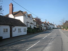
Blewbury là một ngôi làng và xã ở dưới chân của phần Berkshire Downs của Bắc Wessex Downs khoảng 4 dặm (6,4 km) về phía nam của Didcot, 14 dặm (23 km) về phía nam của Oxford và 50 dặm (80 km) về phía tây Luân Đôn. Nó là một phần của Berkshire cho đến năm 1974 khi ranh giới thay đổi chuyển giao nó cho Oxfordshire. Điều tra dân số năm 2011 ghi nhận dân số của xã là 1.581.[1]
Một số con suối phát xuất từ chân vách đá của Berkshire Downs. Một số suối chảy vào một hồ nước nhỏ được gọi là Watercress Beds, nơi cải xoong được trồng. Từ đây và các suối nơi khác chảy vào Mill Brook mà mang nước vào sông Thames tại Wallingford.
Lịch sử

Phần phía Nam của xã là vùng đồi phấn thấp (Downland) và bao gồm một số nơi có từ thời tiền sử. Ridgeway là một đường có từ cổ xưa chạy ngang phía nam của xã.
Một nửa diện tích của đồi Blewburton Hill với độ cao 360 feet (110 m) thuộc về xã. Một pháo đài Anh được xây ở trên đồi vào thời đồ sắt có thể được cư trú từ thế kỷ thứ IV đến thế kỷ thứ I trước Công nguyên. Điểm cao nhất của xã là Churn Hill 520 feet (160 m), 1 1/2 dặm (2,4 km) về phía tây nam của làng.
Tham khảo

- ^ “Area: Blewbury (Parish): Key Figures for 2011 Census: Key Statistics”. Neighbourhood Statistics. Office for National Statistics. Bản gốc lưu trữ ngày 10 tháng 10 năm 2016. Truy cập ngày 6 tháng 6 năm 2015.
Thư mục
- Greenway, Diana E biên tập (1991). Fasti Ecclesiae Anglicanae 1066–1300. 4, Salisbury. Luân Đôn: Nhà xuất bản Đại học Oxford for the Institute of Historical Research. tr. 53–55.
- Horn, Joyce M biên tập (1962). Fasti Ecclesiae Anglicanae 1300–1541. 3, Salisbury Diocese. Luân Đôn: Oxford University Press for the Institute of Historical Research. tr. 36–38.
- Northeast, Peter (1992) [1981]. This Venerable Village. Blewbury: Blewbury Local History Group. ISBN 0950479454.
- Page, W.H.; Ditchfield, P.H. biên tập (1923). A History of the County of Berkshire. Victoria County History. 3. assisted by John Hautenville Cope. Luân Đôn: The St Katherine Press. tr. 280–291.
- Pevsner, Nikolaus (1966). Berkshire. Pevsner Architectural Guides#Buildings of England. Harmondsworth: Penguin Books. tr. 90–92.
Liên kết ngoài
- Blewbury Bulletin
- Blewbury Brass Band Lưu trữ 2012-07-17 tại Wayback Machine
- Blewbury Players
- Blewbury and Wallingford Cricket Club
huyện Vale of White Horse | ||
|---|---|---|
| ||
| Thị xã |
|  |
| Làng lớn |
| |
| Các xã (làng Cụm nhà khác) |
| |
| Huyện Khu tự quản cũ |
| |
| Former constituencies |
| |
| ||


