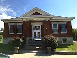
| Coffey County i Kansas |
|---|
 |
| Grunnlagt | 30. aug. 1855 |
|---|
| Fylkessete | Burlington |
|---|
Areal
- Totalt
- Land
- Vann |
1 695,33 km²
1 631,05 km²
64,28 km² |
|---|
Befolkning
- Tetthet | 8 701 (2006)
5,13 innb./km² |
|---|

Coffey County
38°11′N 95°45′V |
Coffey County på Commons |
Coffey County (CF) er et fylke i den amerikanske delstaten Kansas.
Eksterne lenker
- (en) Offisielt nettsted

- (en) Coffey County, Kansas – kategori av bilder, video eller lyd på Commons

|
|---|
| Fylker | Allen · Anderson · Atchison · Barber · Barton · Bourbon · Brown · Butler · Chase · Chautauqua · Cherokee · Cheyenne · Clark · Clay · Cloud · Coffey · Comanche · Cowley · Crawford · Decatur · Dickinson · Doniphan · Douglas · Edwards · Elk · Ellis · Ellsworth · Finney · Ford · Franklin · Geary · Gove · Graham · Grant · Gray · Greeley · Greenwood · Hamilton · Harper · Harvey · Haskell · Hodgeman · Jackson · Jefferson · Jewell · Johnson · Kearny · Kingman · Kiowa · Labette · Lane · Leavenworth · Lincoln · Linn · Logan · Lyon · Marion · Marshall · McPherson · Meade · Miami · Mitchell · Montgomery · Morris · Morton · Nemaha · Neosho · Ness · Norton · Osage · Osborne · Ottawa · Pawnee · Phillips · Pottawatomie · Pratt · Rawlins · Reno · Republic · Rice · Riley · Rooks · Rush · Russell · Saline · Scott · Sedwick · Seward · Shawnee · Sheridan · Sherman · Smith · Stafford · Stanton · Stevens · Sumner · Thomas · Trego · Wabaunsee · Wallace · Washington · Wichita · Wilson · Woodson · Wyandotte | |
|---|
| Større byer | |
|---|
| Oppslagsverk/autoritetsdata | VIAF · LCCN · GeoNames · GNIS |
|---|


