Tameside
Metropolitaans district in Engeland  | |||
|---|---|---|---|
 | |||
 | |||
| Situering | |||
| Land | Engeland | ||
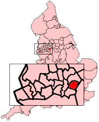
| County | Greater Manchester | ||
| Regio | North West England | ||
| Coördinaten | 53°29'24"NB, 2°5'39"WL | ||
| Algemeen | |||
| Oppervlakte | 103,1543[1] km² | ||
| Inwoners (2018[2]) | 225197 (2183 inw./km²) | ||
| ONS-code | E08000008 | ||
| |||

Tameside is een Engels district in het stedelijk graafschap (metropolitan county) Greater Manchester en telt 225.000 inwoners. De oppervlakte bedraagt 103 km².
Van de bevolking is 14,9% ouder dan 65 jaar. De werkloosheid bedraagt 3,3% van de beroepsbevolking (cijfers volkstelling 2001).
Plaatsen in district Tameside
- Ashton-under-Lyne (hoofdplaats)
- Audenshaw
- Denton
- Droylsden
- Dukinfield
- Flowery Field
- Hyde
- Stalybridge
Civil parishes in district Tameside
Mossley.
Geboren
- Rob Holding (20 september 1995), voetballer
Bronnen, noten en/of referenties
|


