South Lakeland
Niet-metropolitaans district in Engeland  | |||
|---|---|---|---|
 | |||
| Situering | |||
| Land | Engeland | ||
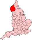
| County | Cumbria | ||
| Regio | North West England | ||
| Coördinaten | 54°18'43"NB, 2°52'48"WL | ||
| Algemeen | |||
| Oppervlakte | 1533,5713[1] km² | ||
| Inwoners (2018[2]) | 104532 (68 inw./km²) | ||
| ONS-code | E07000031 | ||
| Detailkaart | |||
[[Bestand: |266px|class=notpageimage|alt=Kaart van South Lakeland]] |266px|class=notpageimage|alt=Kaart van South Lakeland]] | |||
| |||

South Lakeland is een Engels district in het shire-graafschap (non-metropolitan county OF county) Cumbria en telt 102.301 inwoners. De oppervlakte bedraagt 1534 km².
Van de bevolking is 21,1% ouder dan 65 jaar. De werkloosheid bedraagt 2,0% van de beroepsbevolking (cijfers volkstelling 2001).
Plaatsen in district South Lakeland
- Ambleside
- Swarthmoor
Civil parishes in district South Lakeland
Aldingham, Angerton, Arnside, Barbon, Beetham, Blawith and Subberthwaite, Broughton East, Broughton West, Burton-in-Kendal, Cartmel Fell, Casterton, Claife, Colton, Coniston, Crook, Crosthwaite and Lyth, Dent, Docker, Dunnerdale-with-Seathwaite, Egton with Newland, Fawcett Forest, Firbank, Garsdale, Grange-over-Sands, Grayrigg, Haverthwaite, Hawkshead, Helsington, Heversham, Hincaster, Holme, Hugill, Hutton Roof, Kendal, Kentmere, Killington, Kirkby Ireleth, Kirkby Lonsdale, Lakes, Lambrigg, Levens, Longsleddale, Lower Allithwaite, Lower Holker, Lowick, Lupton, Mansergh, Mansriggs, Meathop and Ulpha, Middleton, Milnthorpe, Natland, Nether Staveley, New Hutton, Old Hutton and Holmescales, Osmotherley, Over Staveley, Pennington, Preston Patrick, Preston Richard, Satterthwaite, Scalthwaiterigg, Sedbergh, Sedgwick, Skelsmergh, Skelwith, Stainton, Staveley-in-Cartmel, Strickland Ketel, Strickland Roger, Torver, Ulverston, Underbarrow and Bradleyfield, Upper Allithwaite, Urswick, Whinfell, Whitwell and Selside, Windermere, Witherslack.
Bronnen, noten en/of referenties
|


