Francueil
Gemeente in Frankrijk  | |||
|---|---|---|---|
 | |||
  | |||
| Situering | |||
| Regio | Centre-Val de Loire | ||
| Departement | Indre-et-Loire (37) | ||
| Arrondissement | Tours | ||
| Kanton | Bléré | ||
| Coördinaten | 47° 19′ NB, 1° 5′ OL | ||
| Algemeen | |||
| Oppervlakte | 12,91 km² | ||
| Inwoners (1 januari 2021) | 1.386[1] (107 inw./km²) | ||
| Hoogte | 54 - 117 m | ||
| Overig | |||
| Postcode | 37150 | ||
| INSEE-code | 37110 | ||
| Foto's | |||
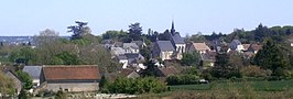 | |||
| Gezicht op Francueil | |||
| |||

Francueil is een gemeente in het Franse departement Indre-et-Loire (regio Centre-Val de Loire). De plaats maakt deel uit van het arrondissement Tours. Francueil telde op 1 januari 2021 1.386[1] inwoners.
Geografie
De oppervlakte van Francueil bedroeg op 1 januari 2021 12,91 vierkante kilometer; de bevolkingsdichtheid was toen 107,4 inwoners per km².

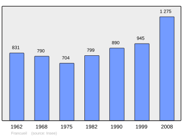
Demografie
Onderstaande figuur toont het verloop van het inwonertal (bron: INSEE-tellingen).
Externe links
- (fr) Statistische informatie op de website van INSEE
Bronnen, noten en/of referenties
- ↑ a b Populations légales 2021.
Mediabestanden
Zie de categorie Francueil van Wikimedia Commons voor mediabestanden over dit onderwerp.


