Bandar Panama
ڤاناماcode: ms is deprecated
Ibu negara

Bendera

Jata
(2010)
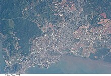
Bandar Panama ialah ibu negara kepada negara Panama
Geografi

Suhu persekitaran
Under the Köppen climate classification, Panama City has a tropical wet and dry climate. Panama City sees 1900 mm of precipitation annually. The wet season spans from May through December, and the dry season spans from January through April. Temperatures remain constant throughout the year, averaging around 27.3 °C (81.1 °F).
| Data iklim untuk Panama City (1971-2000) | |||||||||||||
|---|---|---|---|---|---|---|---|---|---|---|---|---|---|
| Bulan | Jan | Feb | Mac | Apr | Mei | Jun | Jul | Ogo | Sep | Okt | Nov | Dis | Tahun |
| Purata maksimum suhu harian, °C (°F) | 33.4 (92.1) | 34.2 (93.6) | 34.8 (94.6) | 35.4 (95.7) | 34.5 (94.1) | 33.8 (92.8) | 33.9 (93.0) | 33.9 (93.0) | 32.9 (91.2) | 32.6 (90.7) | 32.9 (91.2) | 33.3 (91.9) | 33.8 (92.8) |
| Purata suhu harian, °C (°F) | 26.0 (78.8) | 26.3 (79.3) | 26.6 (79.9) | 27.5 (81.5) | 27.8 (82.0) | 27.6 (81.7) | 27.5 (81.5) | 27.4 (81.3) | 27.0 (80.6) | 26.7 (80.1) | 26.6 (79.9) | 26.3 (79.3) | 26.9 (80.5) |
| Purata minimum suhu harian, °C (°F) | 24.0 (75.2) | 24.4 (75.9) | 25.4 (77.7) | 26.5 (79.7) | 25.1 (77.2) | 25.3 (77.5) | 25.0 (77.0) | 25.9 (78.6) | 25.0 (77.0) | 25.8 (78.4) | 25.3 (77.5) | 25.2 (77.4) | 25.2 (77.4) |
| Purata kerpasan, mm (inci) | 29.3 (1.15) | 10.1 (0.40) | 13.1 (0.52) | 64.7 (2.55) | 225.1 (8.86) | 235.0 (9.25) | 168.5 (6.63) | 219.9 (8.66) | 253.9 (10.00) | 330.7 (13.02) | 252.3 (9.93) | 104.6 (4.12) | 1,907.2 (75.09) |
| Purata bilangan hari kerpasan (≥ 0.1 mm) | 2.9 | 1.3 | 1.4 | 4.9 | 15.0 | 16.0 | 14.0 | 15.0 | 17.0 | 20.0 | 16.0 | 7.5 | 131 |
| Sumber: World Meteorological Organization[2] | |||||||||||||
Cityscape
Seni bina
- Lihat juga: List of tallest buildings in Panama City

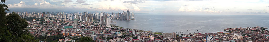
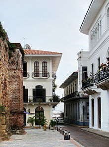
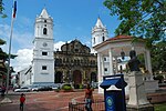
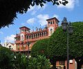
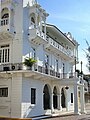
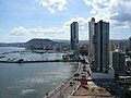
Panama's old quarter features many architectural styles, from Spanish colonial buildings to French and Antillean townhouses built during the construction of the Panama Canal.[3] The more modern areas of the city have many high-rise buildings, which together form a very dense skyline. There are currently more than 110 high-rise projects being constructed, with 127 high-rise buildings already built.[4] The city holds the 40th place in the world by high-rise buildings count.[5]
The Centennial Bridge that crosses the Panama Canal earned the American Segmental Bridge Institute prize of excellence, along with seven other bridges in the Americas.[6]
Jiran

Ekonomi

Being the economic and financial center of the country, Panama City's economy is service-based, heavily weighted toward banking, commerce, and tourism.[7] The economy depends significantly on trade and shipping activities associated with the Panama Canal and port facilities located in Balboa. The city has benefited from significant economic growth in recent years, mainly due to the ongoing expansion of the Panama Canal, an increase in real estate investment, and a relatively stable banking sector.[8] There are around eighty banks in the city, at least fifteen of which are national.

Demografi
Budaya
Tapak Warisan Dunia
 Tapak Warisan Dunia UNESCO Tapak Warisan Dunia UNESCO | |
 | |
| Maklumat am | |
|---|---|
| Nama asli | Panamá |
| Nama rasmi | Panamá |
Sebahagian dari | Central Panama |
| Inskripsi | 1997 (sesi 21st) |
| Lanjutan | 2003 |
| Keluasan | 275 km2 (2.96×10⁹ ka2) |
Laman sesawang | http://mupa.gob.pa |
| Maklumat lokasi | |
| Lokasi | Panamá District, Panama |
| Koordinat | 9°00′N 79°30′W / 9°N 79.5°W / 9; -79.5 |
  Bandar Panama (Bumi) | |
 | |
sunting · sunting di Wikidata | |
Kesusasteraan
According to Professor Rodrigo Miró, the first story about Panama was written by Gonzalo Fernández de Oviedo y Valdés and published as part of the Historia General y Natural de Las Indias in 1535. Some poets and novelists born in Panamá city are Manuel María Ayala (1785–1824), Amelia Denis de Icaza (1836–1911), Darío Herrera (1870–1914), Ricardo Miró (1883–1940), Gaspar Octavio Hernández (1893–1918), Demetrio Korsi (1899–1957), Ricardo Bermúdez (1914–2000), Joaquín Beleño (1922–88), Ernesto Endara (1932–), Diana Morán (1932–87), José Córdova (1937–), Pedro Rivera (1939–), Moravia Ochoa López (1941–), Roberto Fernández Iglesias (1941–), Jarl Ricardo Babot (1946–), Giovanna Benedetti (1949–), Manuel Orestes Nieto (1951–), Moisés Pascual (1955–), Héctor Miguel Collado (1960–), David Robinson Orobio (1960–), Katia Chiari (1969–), Carlos Oriel Wynter Melo (1971–), José Luis Rodríguez Pittí (1971–), and Sofía Santim (1982–).[9]
Pelancongan
—
-
 The Interoceanic Canal Museum
 -
 Plaza de la Independencia
 -
 Archway and classic calicanto wall in a traditional house
 -
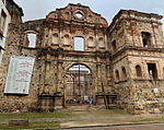 Compañía de Jesús, the ruins of an ancient convent of the Society of Jesus


Sukan
-
 Rommel Fernandez Stadium
 -
 Rod Carew National Stadium
 -
 Roberto Duran Arena


Pendidikan
Kesihatan
-
 Hospital Santo Tomás, the largest public hospital in the country
 -
 Hospital Nacional, a full-service private hospital
 -
 Instituto Oncológico Nacional, at former Gorgas Hospital
 -
 The Gorgas Memorial Institute for Health Studies


Pengangkutan
-
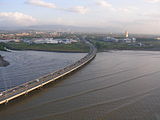 The puente marino ("marine bridge"), Corredor Sur ("South Corridor")
 -
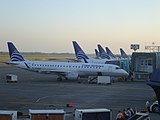 Tocumen International Airport, Panama's international airport
 -
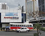 Old public buses
 -
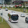 Metrobus, the new public transport system, currently under implementation
 -
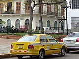 Taxi in Panama City


Galeri
-
 The belltower of the San Francisco Church.
 -
 Plaza Bolivar in Casco Viejo
 -
 Ruins of the Old Panama
 -
 Santa Ana Park
 -
 Causeway connecting Naos, Perico, and Flamenco Islands to the mainland
 -
 The Bridge of the Americas, at the Pacific entrance to the Panama Canal
 -
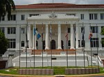
 Governmental office and residence of the president of Panama
 -
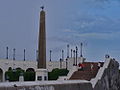 Plaza de Francia, a square in honor of the workers and French engineers who participated in the construction of the Panama Canal.
 -
 Skyline seen from Casco Viejo
 -
 The former Balboa Avenue
 -
 Panama skycrapers
 -
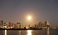 Panama Bay
 -
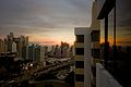 View of part of the metropolitan area of Panama


Lihat juga
- Casco Viejo, Panama
- Panama Canal
Rujukan
Nota kaki
- ^ "Informe de Desarrollo Humano en Panamá" (dalam bahasa Spanish). 2007. Diarkibkan daripada yang asal pada 2013-11-03. Dicapai pada 7 September 2010.CS1 maint: unrecognized language (link)
- ^ "World Weather Information Service - Panama City". World Meteorological Organization. Dicapai pada 2012-08-04.
- ^ "In Panama City's Old Quarter, a Rebirth Takes Place". Boston Globe. 2007-01-22. Dicapai pada 2011-02-11.
- ^ "Skyscraper page Panama City". Skyscraperpage.com. Dicapai pada 2010-06-26.
- ^ "Skyscraper page Cities List". Skyscraperpage.com. Dicapai pada 2010-06-26.
- ^ "La Prensa Newspaper". Mensual.prensa.com. Dicapai pada 2010-06-26.
- ^ "Panama Useful Facts". Diarkibkan daripada yang asal pada 2020-02-21. Dicapai pada 2011-02-17.
- ^ "Panama economy grew 2.4 percent in 2009". Reuters. 2010-03-02. Diarkibkan daripada yang asal pada 2014-02-01. Dicapai pada 2011-02-17.
- ^ Panamanian literature
Bibliografi
- Mellander, Gustavo A.; Nelly Maldonado Mellander (1999). Charles Edward Magoon: The Panama Years. Río Piedras, Puerto Rico: Editorial Plaza Mayor. ISBN 1-56328-155-4. OCLC 42970390.
- Mellander, Gustavo A. (1971). The United States in Panamanian Politics: The Intriguing Formative Years. Danville, Ill.: Interstate Publishers. OCLC 138568.
Pautan luar
| Ketahui lebih lanjut tentang Panama City di Wikipedia: | |
 | Takrifan dari Wikikamus |
| Imej dan media dari Commons | |
| Sumber pembelajaran dari Wikiversity | |
| Berita dari Wikiberita | |
| Petikan dari Wikipetikan | |
| Teks sumber dari Wikisumber | |
| Buku teks dari Wikibuku | |
- Official website for Panama City
- Official website for Panama's Tourism Bureau


