County Bell, Texas
| Bell County, Texas | |
|---|---|
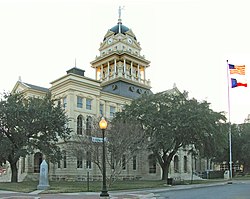 The Bell County Courthouse in Belton. | |
 Lokasi di negara bagian Texas | |
 Lokasi negara bagian Texas di Amerika Serikat | |
| Didirikan | 1850 |
| Seat | Belton |
| Wilayah | |
| • Keseluruhan | 1.088 sq mi (2.818 km2) |
| • Daratan | 1.060 sq mi (2.745 km2) |
| • Perairan | 28 sq mi (73 km2), 2.59% |
| Populasi | |
| • (2010) | 310,235 |
| • Kepadatan | 292,7/sq mi (113/km²) |
| Situs web | www |
Bell County adalah county yang terletak di negara bagian Texas, Amerika Serikat. Jumlah penduduk pada tahun 2010 sebesar 310.235 jiwa.
Jalan utama
 Interstate 35
 U.S. Highway 190
 State Highway 36
 State Highway 53
 State Highway 95
 State Highway 195


Pranala luar
- Bell County Home Page
- Bell County in Handbook of Texas Online at the University of Texas.
- Bell County Ex Confederate Association Ledger, From 1888 To 1920.
- Historic Bell County materials, hosted by the Portal to Texas History.
 | Coryell County | McLennan County | Falls County | |
| Lampasas County |  | |||
| ||||
 | ||||
| Burnet County | Williamson County | Milam County |

Templat:Bell County, Texas
 Negara bagian Texas Negara bagian Texas | |
|---|---|
Austin (ibu kota) | |
| Topik |
|
| Region |
|
| Wilayah metro |
|
| County |
|
 | Artikel bertopik geografi atau tempat Amerika Serikat ini adalah sebuah rintisan. Anda dapat membantu Wikipedia dengan mengembangkannya. |
- l
- b
- s


