Varberg Municipality
Municipality in Halland County, Sweden
Varberg Municipality Varbergs kommun | |
|---|---|
Municipality | |
 | |
 Coat of arms | |
 | |
| Coordinates: 57°06′N 12°15′E / 57.1°N 12.25°E / 57.1; 12.25 | |
| Country | Sweden |
| County | Halland County |
| Seat | Varberg |
| Area | |
| • Total | 1,703.35 km2 (657.67 sq mi) |
| • Land | 868.71 km2 (335.41 sq mi) |
| • Water | 834.64 km2 (322.26 sq mi) |
| Area as of 1 January 2014. | |
| Population (31 December 2023)[2] | |
| • Total | 68,325 |
| • Density | 40/km2 (100/sq mi) |
| Time zone | UTC+1 (CET) |
| • Summer (DST) | UTC+2 (CEST) |
| ISO 3166 code | SE |
| Province | Halland and Västergötland |
| Municipal code | 1383 |
| Website | www.varberg.se |

Varberg Municipality (Varbergs kommun) is a municipality in Halland County, in southwest Sweden. Its seat is in Varberg.
It was formed in 1971 through the amalgamation of the City of Varberg and the surrounding rural municipalities. There are 25 original local government entities included in the municipality.
5,000 people are commuting out from the municipality, mainly to Gothenburg and Falkenberg. 3,200 people are commuting into Falkenberg.
Localities
There are 16 urban areas (also called a tätort or locality) in Varberg Municipality.
In the table the localities are listed according to the size of the population as of December 31, 2005. The municipal seat is in bold characters.
| # | Locality | Population |
|---|---|---|
| 1 | Varberg | 26,041 |
| 2 | Tvååker | 2,390 |
| 3 | Veddige | 2,192 |
| 4 | Träslövsläge | 1,985 |
| 5 | Bua | 1,792 |
| 6 | Trönninge | 847 |
| 7 | Skällinge | 603 |
| 8 | Södra Näs | 600 |
| 9 | Väröbacka | 521 |
| 10 | Rolfstorp | 502 |
| 11 | Tångaberg | 445 |
| 12 | Åsby | 429 |
| 13 | Kungsäter | 360 |
| 14 | Tofta | 350 |
| 15 | Himle | 259 |
| 16 | Löftaskog | 226 |
Demographics
This is a demographic table based on Varberg Municipality's electoral districts in the 2022 Swedish general election sourced from SVT's election platform, in turn taken from SCB official statistics.[3]
In total there were 66,604 inhabitants, including 51,969 Swedish citizens of voting age.[3] 47.3% voted for the left coalition and 51.7% for the right coalition. Indicators are in percentage points except population totals and income.
| Location | Residents | Citizen adults | Left vote | Right vote | Employed | Swedish parents | Foreign heritage | Income SEK | Degree |
|---|---|---|---|---|---|---|---|---|---|
| % | % | ||||||||
| Apelviken-Nygård | 1,395 | 1,234 | 45.0 | 54.7 | 86 | 92 | 8 | 30,266 | 54 |
| Barnabro-Lugnet-Getterön | 1,481 | 1,154 | 56.4 | 42.4 | 85 | 80 | 20 | 28,043 | 48 |
| Bläshammar-Trönningenäs | 1,982 | 1,358 | 46.2 | 53.0 | 89 | 88 | 12 | 31,881 | 51 |
| Breared | 2,326 | 1,793 | 51.7 | 47.5 | 88 | 82 | 18 | 28,775 | 50 |
| Brunnsberg-Norrdal | 1,809 | 1,515 | 50.6 | 47.6 | 80 | 69 | 31 | 24,597 | 39 |
| Bua | 2,187 | 1,697 | 39.1 | 59.9 | 85 | 89 | 11 | 26,393 | 38 |
| Derome-Sällstorp | 1,424 | 1,062 | 38.6 | 60.3 | 88 | 90 | 10 | 27,700 | 30 |
| Gamleby | 1,741 | 1,670 | 45.0 | 54.0 | 87 | 85 | 15 | 26,782 | 45 |
| Grimeton-Gödestad | 1,868 | 1,356 | 40.1 | 58.6 | 88 | 92 | 8 | 27,800 | 35 |
| Håsten | 2,136 | 1,517 | 55.8 | 42.2 | 71 | 61 | 39 | 21,117 | 24 |
| Hästhaga-Rosenfred | 1,660 | 1,439 | 51.0 | 48.2 | 84 | 91 | 9 | 28,973 | 49 |
| Karl Gustav-Grimmared | 665 | 526 | 37.7 | 61.1 | 82 | 92 | 8 | 22,932 | 27 |
| Karlberg | 1,717 | 1,329 | 55.2 | 44.3 | 89 | 88 | 12 | 29,582 | 53 |
| Kungsäter-Gunnarsjö | 833 | 660 | 41.6 | 57.5 | 84 | 89 | 11 | 23,427 | 26 |
| Lilla Träslöv | 1,604 | 1,209 | 48.5 | 50.2 | 86 | 83 | 17 | 29,441 | 51 |
| Lindberg-Tofta-Torpa | 1,277 | 939 | 40.6 | 58.9 | 89 | 92 | 8 | 29,282 | 38 |
| Lorensberg-Tranelyckan | 1,410 | 1,244 | 51.6 | 47.8 | 80 | 91 | 9 | 24,614 | 53 |
| Mariedal | 1,397 | 1,133 | 51.8 | 47.4 | 84 | 83 | 17 | 26,583 | 45 |
| Rolfstorp | 1,120 | 827 | 45.0 | 53.1 | 87 | 91 | 9 | 26,819 | 32 |
| Sibbarp-Dagsås | 883 | 670 | 49.5 | 49.5 | 80 | 88 | 12 | 25,230 | 32 |
| Skällinge-Nösslinge | 1,100 | 828 | 48.2 | 50.6 | 86 | 92 | 8 | 26,061 | 31 |
| Spannarp | 723 | 541 | 41.1 | 58.0 | 92 | 89 | 11 | 27,328 | 32 |
| Stenåsa-Äckregården | 1,710 | 1,450 | 54.0 | 45.1 | 84 | 84 | 16 | 26,977 | 43 |
| Stråvalla | 1,211 | 932 | 41.5 | 57.8 | 90 | 91 | 9 | 29,303 | 40 |
| Sörse-Apelvikshöjd | 1,940 | 1,552 | 60.4 | 38.1 | 76 | 70 | 30 | 21,254 | 38 |
| Sörse-Ranelid | 1,694 | 1,369 | 61.2 | 37.7 | 74 | 70 | 30 | 22,158 | 32 |
| Trädlyckan | 1,349 | 1,127 | 49.5 | 49.0 | 85 | 80 | 20 | 26,345 | 43 |
| Träslöv N | 1,591 | 1,159 | 49.7 | 49.8 | 89 | 93 | 7 | 31,778 | 47 |
| Träslöv S | 1,763 | 1,300 | 49.6 | 50.3 | 90 | 89 | 11 | 32,731 | 54 |
| Träslövsläge NV | 1,970 | 1,493 | 42.3 | 56.5 | 89 | 94 | 6 | 30,451 | 57 |
| Träslövsläge SÖ | 1,791 | 1,299 | 45.1 | 53.4 | 87 | 92 | 8 | 29,560 | 47 |
| Tvååker V | 2,209 | 1,611 | 47.3 | 51.2 | 83 | 83 | 17 | 25,432 | 33 |
| Tvååker Ö | 1,940 | 1,452 | 46.0 | 53.4 | 85 | 88 | 12 | 25,917 | 32 |
| Trönninge-Göingegården | 2,674 | 1,863 | 47.2 | 51.7 | 89 | 85 | 15 | 31,022 | 50 |
| Tångaberg-Kärra-Åskloster | 1,885 | 1,515 | 40.9 | 57.8 | 85 | 91 | 9 | 29,498 | 44 |
| Valinge-Stamnared | 1,094 | 823 | 40.5 | 58.6 | 88 | 94 | 6 | 26,535 | 35 |
| Varberg Centrum N | 1,723 | 1,503 | 50.5 | 47.8 | 78 | 82 | 18 | 24,373 | 42 |
| Varberg Centrum S | 1,683 | 1,591 | 46.9 | 52.1 | 82 | 89 | 11 | 26,274 | 47 |
| Veddige V | 1,958 | 1,496 | 43.9 | 55.3 | 86 | 86 | 14 | 25,505 | 34 |
| Veddige Ö | 1,463 | 987 | 42.1 | 57.1 | 81 | 78 | 22 | 23,895 | 26 |
| Värö | 2,218 | 1,746 | 39.3 | 60.0 | 85 | 88 | 12 | 25,372 | 32 |
| Source: SVT[3] | |||||||||
International relations
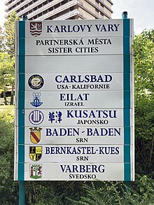
Twin towns — Sister cities
The municipality is twinned with:[4]
 Karlovy Vary, Czech Republic
 Haderslev Municipality, Denmark
 Tartumaa, Estonia
 Uusikaupunki, Finland
 Sandefjord, Norway


References
- ^ "Statistiska centralbyrån, Kommunarealer den 1 januari 2014" (in Swedish). Statistics Sweden. 2014-01-01. Archived from the original (Microsoft Excel) on 2016-09-27. Retrieved 2014-04-18.
- ^ "Folkmängd och befolkningsförändringar - Kvartal 4, 2023" (in Swedish). Statistics Sweden. February 22, 2024. Retrieved February 22, 2024.
- ^ a b c "Valresultat 2022 för Varberg i riksdagsvalet" (in Swedish). SVT. 11 September 2022. Retrieved 3 January 2024.
- ^ "Archived copy" (PDF). Archived from the original (PDF) on 2011-09-01. Retrieved 2010-05-22.
{{cite web}}: CS1 maint: archived copy as title (link)
External links
Wikimedia Commons has media related to Varberg Municipality.
 Varberg travel guide from Wikivoyage
- Varberg Municipality - Official site
- Halland County Museum at Varberg - Official site
- Coat of arms
- Varberg Municipality Vacancies
Places adjacent to Varberg Municipality | ||||||||||||||||
|---|---|---|---|---|---|---|---|---|---|---|---|---|---|---|---|---|
| ||||||||||||||||


- v
- t
- e
Municipalities and seats of Halland County
- Falkenberg
- Halmstad
- Hylte
- Kungsbacka
- Laholm
- Varberg

Authority control databases | |
|---|---|
| International |
|
| National |
|
| Geographic |
|


