Ulrum
Village in Groningen, Netherlands

Flag

Coat of arms
(2021)[1]
9971[1]
Ulrum (Dutch pronunciation: [ˈʏlrʏm]; Gronings: Ollerom [ˈɔɫəɾɔm]) is a village in the Dutch province of Groningen. It is located in the municipality of Het Hogeland.
History
The first time the town was named was as Uluringhem in the 11th century.
Ulrum is sited on two mounds. On the western one stands the Romano-Gothic church of Ulrum (built at the end of the 12th century), on the eastern mound stood the Asingaborg.
Ulrum was once a thriving village with many tradesmen and small businesses. Now only agricultural activity remains.
Ulrum was a separate municipality until 1990, when it merged with Eenrum, Kloosterburen, and Leens. The new municipality was called Ulrum at first, but was renamed to De Marne in 1992.[3]
Gallery
-
 Farm in Ulrum
 -
 House in Ulrum
 -
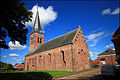 Protestant Church in Ulrum
 -
 Borg Asinga


References
- ^ a b c "Kerncijfers wijken en buurten 2021". Central Bureau of Statistics. Retrieved 8 April 2022.
two entries
- ^ "Postcodetool for 9971AA". Actueel Hoogtebestand Nederland (in Dutch). Het Waterschapshuis. Retrieved 8 April 2022.
- ^ Ad van der Meer and Onno Boonstra, Repertorium van Nederlandse gemeenten, KNAW, 2011.
External links
 Media related to Ulrum at Wikimedia Commons
- v
- t
- e
Populated places in the municipality of Het Hogeland
- Adorp
- Den Andel
- Baflo
- Bedum
- Eenrum
- Hornhuizen [nl]
- Houwerzijl
- Kantens
- Kleine Huisjes
- Kloosterburen
- Lauwersoog
- Leens
- Mensingeweer
- Niekerk [nl]
- Noordwolde
- Oldenzijl
- Onderdendam
- Oosteinde
- Oosternieland
- Oudeschip
- Pieterburen
- Rasquert [nl]
- Roodeschool
- Rottum
- Saaxumhuizen [nl]
- Sauwerd
- Stitswerd
- Tinallinge [nl]
- Uithuizen
- Uithuizermeeden
- Ulrum
- Usquert
- Warffum
- Warfhuizen
- Wehe-den Hoorn
- Westernieland
- Wetsinge
- Winsum
- Zandeweer
- Zoutkamp
- Zuidwolde
- Zuurdijk [nl]
 | This Groningen location article is a stub. You can help Wikipedia by expanding it. |
- v
- t
- e


