Thorildsplan metro station
Stockholm Metro station
59°19′53″N 18°00′53″E / 59.33139°N 18.01472°E / 59.33139; 18.01472| Preceding station |  Stockholm metro Stockholm metro | Following station | ||
|---|---|---|---|---|
| Kristineberg towards Åkeshov | Line 17 | Fridhemsplan towards Skarpnäck | ||
| Kristineberg towards Alvik | Line 18 | Fridhemsplan towards Farsta strand | ||
| Kristineberg towards Hässelby strand | Line 19 | Fridhemsplan towards Hagsätra | ||
Location | |
|---|---|
 |
Thorildsplan metro station is a station on the Green line of the Stockholm metro. It takes its name from the nearby park of Thorildsplan, which in turn is named after the writer Thomas Thorild, and is in the district of Kristineberg, which is in the borough of Kungsholmen in central Stockholm. The station has a single island platform and is located in the centre of Drottningholmsvägen, with access from a pedestrian underpass at its eastern end that passes under both road and rail line.[2][3] The distance to Slussen is 6.1 km (3.8 mi).[citation needed]
The station was inaugurated on 26 October 1952 as a part of the section of line between Hötorget and Vällingby.[2]
As part of Art in the Stockholm metro project, the station has two distinct art works. A relief of a sun on the track wall is by Huck Hultgren and dates from 1975. A painting of concrete surfaces on the theme of Thomas Thorild, genius, inventor, thinker is by Tobias Apelgren and Lou Åberg and dates from 1998.[4]
Gallery
-
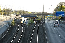 Station seen from east, 2011
 -
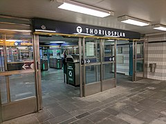 Entrance from underpass, 2017
 -
 Ticket hall, 2017
 -
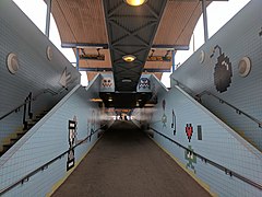 Access to platform, 2017


References
- ^ "Fakta om SL och regionen 2019" (PDF) (in Swedish). Storstockholms Lokaltrafik. p. 51. Archived (PDF) from the original on 27 December 2020. Retrieved 1 April 2021.
- ^ a b Schwandl, Robert. "Stockholm". urbanrail. Archived from the original on 23 April 2019. Retrieved 7 May 2019.
- ^ "Thorildsplan". Google maps. Retrieved 14 March 2022.
- ^ "Art in the Stockholm metro" (PDF). Stockholm Transport. Archived from the original (PDF) on 13 September 2008. Retrieved 10 September 2008.
- v
- t
- e

| Shared stations | |
|---|---|
| 17 | |
| 18 |
|
| 19 |


 | This article about a Swedish railway station is a stub. You can help Wikipedia by expanding it. |
- v
- t
- e
 | This Stockholm Metro article is a stub. You can help Wikipedia by expanding it. |
- v
- t
- e


