Tam Đường district
You can help expand this article with text translated from the corresponding article in Vietnamese. (March 2009) Click [show] for important translation instructions.
- View a machine-translated version of the Vietnamese article.
- Machine translation, like DeepL or Google Translate, is a useful starting point for translations, but translators must revise errors as necessary and confirm that the translation is accurate, rather than simply copy-pasting machine-translated text into the English Wikipedia.
- Do not translate text that appears unreliable or low-quality. If possible, verify the text with references provided in the foreign-language article.
- You must provide copyright attribution in the edit summary accompanying your translation by providing an interlanguage link to the source of your translation. A model attribution edit summary is
Content in this edit is translated from the existing Vietnamese Wikipedia article at [[:vi:Tam Đường]]; see its history for attribution. - You may also add the template
{{Translated|vi|Tam Đường}}to the talk page. - For more guidance, see Wikipedia:Translation.
District in Northwest, Vietnam
Tam Đường District Huyện Tam Đường | |
|---|---|
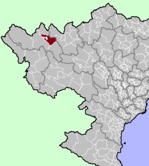 District location in northern Vietnam | |
| Country |  Vietnam Vietnam |
| Region | Northwest |
| Province | Lai Châu |
| Capital | Tam Đường |
| Area | |
| • Total | 662.92 km2 (255.95 sq mi) |
| Population (2020)[1] | |
| • Total | 52,470 |
| • Density | 79/km2 (200/sq mi) |
| Time zone | UTC+7 (Indochina Time) |
| Website | tamduong |
Tam Đường is a rural district of Lai Châu province in the Northwest region of Vietnam. The city borders Phong Thổ district, Sìn Hồ district, Tân Uyên district, Lai Châu and Lào Cai province.
The district capital lies at Tam Đường.[2]
Demographics
As of 2020 the city had a population of 52,470, covering an area of 662.92 km².[1]
Administrative divisions
Lai Châu City is officially divided into 13 commune-level sub-divisions, including the township of Tam Đường and 12 rural communes (Bản Bo, Bản Giang, Bản Hon, Bình Lư, Giang Ma, Hồ Thầu, Khun Há, Nà Tăm, Nùng Nàng, Sơn Bình, Tả Lèng, Thèn Sin).[1]
Climate
| Climate data for Tam Dương, elevation 900 m (3,000 ft) | |||||||||||||
|---|---|---|---|---|---|---|---|---|---|---|---|---|---|
| Month | Jan | Feb | Mar | Apr | May | Jun | Jul | Aug | Sep | Oct | Nov | Dec | Year |
| Record high °C (°F) | 28.7 (83.7) | 31.2 (88.2) | 34.0 (93.2) | 34.7 (94.5) | 34.5 (94.1) | 32.4 (90.3) | 32.7 (90.9) | 33.4 (92.1) | 32.2 (90.0) | 31.0 (87.8) | 29.5 (85.1) | 28.0 (82.4) | 34.7 (94.5) |
| Mean daily maximum °C (°F) | 18.8 (65.8) | 21.0 (69.8) | 24.4 (75.9) | 27.0 (80.6) | 27.5 (81.5) | 27.0 (80.6) | 26.8 (80.2) | 27.5 (81.5) | 27.0 (80.6) | 25.1 (77.2) | 22.1 (71.8) | 19.3 (66.7) | 24.5 (76.0) |
| Daily mean °C (°F) | 13.6 (56.5) | 15.4 (59.7) | 18.7 (65.7) | 21.4 (70.5) | 22.7 (72.9) | 23.1 (73.6) | 22.9 (73.2) | 23.1 (73.6) | 22.2 (72.0) | 20.2 (68.4) | 16.9 (62.4) | 13.9 (57.0) | 19.5 (67.1) |
| Mean daily minimum °C (°F) | 10.1 (50.2) | 11.4 (52.5) | 14.3 (57.7) | 17.2 (63.0) | 19.3 (66.7) | 20.7 (69.3) | 20.6 (69.1) | 20.4 (68.7) | 19.2 (66.6) | 17.0 (62.6) | 13.5 (56.3) | 10.3 (50.5) | 16.2 (61.2) |
| Record low °C (°F) | 0.8 (33.4) | 3.2 (37.8) | 2.9 (37.2) | 7.9 (46.2) | 11.9 (53.4) | 15.0 (59.0) | 16.9 (62.4) | 17.0 (62.6) | 12.7 (54.9) | 7.2 (45.0) | 4.0 (39.2) | −0.4 (31.3) | −0.4 (31.3) |
| Average precipitation mm (inches) | 40.1 (1.58) | 39.0 (1.54) | 81.2 (3.20) | 185.1 (7.29) | 340.4 (13.40) | 472.5 (18.60) | 545.2 (21.46) | 340.0 (13.39) | 186.2 (7.33) | 131.9 (5.19) | 75.3 (2.96) | 35.1 (1.38) | 2,469 (97.20) |
| Average rainy days | 7.2 | 7.0 | 8.4 | 14.0 | 21.9 | 25.2 | 26.3 | 23.0 | 16.3 | 12.5 | 8.2 | 5.1 | 175.0 |
| Average relative humidity (%) | 81.2 | 77.0 | 73.0 | 75.9 | 81.3 | 87.2 | 89.0 | 87.6 | 86.0 | 84.3 | 82.3 | 81.7 | 82.2 |
| Mean monthly sunshine hours | 161.5 | 167.0 | 189.3 | 204.3 | 186.4 | 114.5 | 117.2 | 145.2 | 157.6 | 156.4 | 164.1 | 168.0 | 1,936.8 |
| Source: Vietnam Institute for Building Science and Technology[3] | |||||||||||||
See also
References
- v
- t
- e
Districts of Northwest Vietnam

※ denotes provincial seat.
22°19′22″N 103°37′38″E / 22.32278°N 103.62722°E / 22.32278; 103.62722
 | This article about a location in Lai Châu Province, Vietnam is a stub. You can help Wikipedia by expanding it. |
- v
- t
- e


