South Norwood Lake and Grounds
| South Norwood Lake and Grounds | |
|---|---|
 South Norwood Lake | |
 | |
| Type | Public park |
| Location | South Norwood |
| Operated by | London Borough of Croydon |
| Status | Open all year |
| Public transit access | 410 bus to Harris City Academy stop |
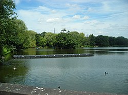
South Norwood Lake and Grounds is a park in South Norwood in the London Borough of Croydon. The main entrance is in Woodvale Avenue while other entrances are located in Auckland Road and Sylvan Road. The area measures up to 281⁄2 acres (11.53 hectares).[1]
As well as the lake, there is a bowling green, tennis and basketball courts, football pitches, a cricket pitch, a playground and a trim trail. The park has active park rangers and has a park ranger's office with adjoining public toilets.
The lake was originally created as a reservoir for the Croydon Canal, which, from 1809 to 1836, ran between Croydon and the Grand Surrey Canal at New Cross.[2] As of May 2019[update], it is used by local anglers, who fish for carp, bream and perch among others, and Croydon Sailing Club. The lake is also home to a variety of aquatic birds including a number of great crested grebes as well as regularly sighted herons and ring-necked parakeets that can be seen nesting on the island.
In 2004, blue green algae resulted in the death of significant numbers of fish, and the predominant species left were carp and perch.[3] The lake itself has natural food sources for fish including a blood worm bar.
Norwood Sports Club

The grounds are also home to the Norwood Sports Club. Founded in 1881 by Alfred Steer, the club leased 16 acres which included the lake and in 1888 a further 37 acres were leased from the Ecclesiastical Commissioners.[4] At that point the club was the largest tennis club in the world with 54 courts.[4] Faciliities then included bowls, tennis, cricket and golf as well as the lake. The golf course was requisitioned during World War I and was damaged and fell into disuse thereafter.[4] The grounds were used by British Dominion Insurance as a staff sports ground from 1920,[4] before the original 16 acres were purchased by Croydon Council in 1931.[4] The additional 37 acres were firstly leased in 1933 and subsequently purchased in 1936, by the council. The sports club leased most of the land until 1947 when 33.5 acres were relinquished. The grounds were opened fully to the public in 1969 but the club still retains some user rights.[4]
See also
References
- ^ Winterman, M.A. (1988). Croydon's Parks: An illustrated history. London Borough of Croydon, Parks and Recreation Department. p. 95. ISBN 0951348108.
- ^ "South Norwood Lake and Grounds history" (PDF). croydon.gov.uk. London Borough of Croydon. Retrieved 23 May 2019.
- ^ "Norwood Lake Fishing webpage". Maggotdrowning.com. Retrieved 27 February 2019.
- ^ a b c d e f Winterman, M.A. (1988). Croydon's Parks: An illustrated history. London Borough of Croydon, Parks and Recreation Department. pp. 96–7. ISBN 0951348108.
External links
- South Norwood Lake & Grounds webpage
- Croydon Sailing Club
- History at Croydon Council website
- Croydon Council - South Norwood Lake and Grounds
- v
- t
- e
- Addington
- Addiscombe
- Beddington
- Broad Green
- Coombe
- Coulsdon
- Croydon
- Crystal Palace
- Forestdale
- Hamsey Green
- Kenley
- Monks Orchard
- New Addington
- Norbury
- Norwood New Town
- Old Coulsdon
- Old Town
- Pollards Hill
- Purley
- Russell Hill
- Sanderstead
- Selhurst
- Selsdon
- Shirley (Including Shirley Oaks and Upper Shirley)
- South Croydon
- South Norwood
- Spring Park
- Thornton Heath
- Upper Norwood
- Waddon
- Woodcote
- Woodside
- Whyteleafe


open spaces
- Addington Hills
- Addington Park
- Addington Vale
- Addiscombe Railway Park
- Addiscombe Recreation Ground
- Apsley Road Playground
- Ashburton Park
- Ashburton Playing Fields
- Beaulieu Heights
- Bramley Bank
- Brickfields Meadow
- Coombe Wood
- Cotelands
- Croham Hurst
- Duppas Hill
- Farthing Downs
- Foxley Wood
- Grangewood Park
- Great North Wood
- Happy Valley Park
- Heathfield House
- Heavers Meadow
- Hutchinson's Bank
- Kenley Common
- Littleheath Woods
- Lloyd Park
- Mitcham Common
- Norwood Grove
- Park Hill
- Pollards Hill
- Queen's Gardens
- Riddlesdown Common
- Roundshaw
- Selsdon Wood
- South Norwood Country Park
- South Norwood Lake and Grounds
- South Norwood Recreation Ground
- Spa Wood
- Wandle Park
- Woodside Green
- Croydon South
- Croydon Central
- Croydon North
- Addiscombe East
- Addiscombe West
- Bensham Manor
- Broad Green
- Coulsdon Town
- Crystal Palace & Upper Norwood
- Fairfield
- Kenley
- New Addington North
- New Addington South
- Norbury & Pollards Hill
- Norbury Park
- Old Coulsdon
- Park Hill & Whitgift
- Purley & Woodcote
- Purley Oaks & Riddlesdown
- Sanderstead
- Selhurst
- Selsdon & Addington Village
- Selsdon Vale & Forestdale
- Shirley North
- Shirley South
- South Croydon
- South Norwood
- Thornton Heath
- Waddon
- West Thornton
- Woodside
and tram stops
- Addington Village
- Addiscombe
- Ampere Way
- Arena
- Blackhorse Lane
- Centrale
- Church Street
- Coombe Lane
- Coulsdon South
- Coulsdon Town
- East Croydon
- Fieldway
- George Street
- Gravel Hill
- Harrington Road
- Kenley
- King Henry's Drive
- Lebanon Road
- Lloyd Park
- New Addington
- Norbury
- Norwood Junction
- Purley Oaks
- Purley
- Reedham
- Reeves Corner
- Riddlesdown
- Sanderstead
- Sandilands
- Selhurst
- South Croydon
- Thornton Heath
- Waddon
- Waddon Marsh
- Wandle Park
- Wellesley Road
- West Croydon
- Woodmansterne
- Woodside
 Category
 Commons

51°24′25″N 0°04′26″W / 51.407°N 0.074°W / 51.407; -0.074
 | This London location article is a stub. You can help Wikipedia by expanding it. |
- v
- t
- e


