Soestduinen
Hamlet in Utrecht, Netherlands
52°8′45″N 5°17′55″E / 52.14583°N 5.29861°E / 52.14583; 5.29861 (2021)[1]
3768[1]
Soestduinen is a hamlet in the Dutch province of Utrecht. It is a part of the municipality of Soest, and lies about 3 km south of Soest.
The hamlet was first mentioned in 1936 as Soestduinen, and means the dunes near Soest.[3] The railway station Soestduinen has existed between 1863 and 1998, and was called Soestduinen since 1922.[4] The hamlet has always had place name signs, but since 2009, it reads Soest with Soestduinen underneath to emphasise that it is a hamlet belonging to Soest.[5]
Gallery
-
 Pumping station
 -
 Former railway station building
 -
 Houses in Soestduinen
 -
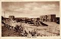 Old postcard of a holiday resort in Soestduinen


References
- ^ a b c "Kerncijfers wijken en buurten 2021". Central Bureau of Statistics. Retrieved 27 March 2022.
- ^ "Postcodetool for 3768AA". Actueel Hoogtebestand Nederland (in Dutch). Het Waterschapshuis. Retrieved 27 March 2022.
- ^ "Soestduinen - (geografische naam)". Etymologiebank (in Dutch). Retrieved 27 March 2022.
- ^ "station Soestduinen". Stationsweb (in Dutch). Retrieved 27 March 2022.
- ^ "Soestduinen". Plaatsengids (in Dutch). Retrieved 27 March 2022.
Wikimedia Commons has media related to Soestduinen.
- v
- t
- e
Populated places in the municipality of Soest
- Soest
- Soesterberg
- De Birkt
- Grote Melm
- Hees
- Pijnenburg
- Soestdijk
- Soestduinen
 | This Utrecht location article is a stub. You can help Wikipedia by expanding it. |
- v
- t
- e


