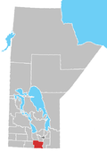
Rural Municipality of Dufferin
Dufferin is a rural municipality in the province of Manitoba in Western Canada. The separately administered town of Carman lies near its centre.
The R.M. was named after Frederick Hamilton-Temple-Blackwood, 1st Marquess of Dufferin and Ava who was Governor General of Canada (1872–78). The now rural municipality was described as a new settlement in 1874.
Communities
- Barnsley
- Graysville
- Homewood
- Roseisle
- Stephenfield
Demographics
In the 2021 Census of Population conducted by Statistics Canada, Dufferin had a population of 2,543 living in 761 of its 806 total private dwellings, a change of 4.4% from its 2016 population of 2,435. With a land area of 916.11 km2 (353.71 sq mi), it had a population density of 2.8/km2 (7.2/sq mi) in 2021.[1]
References
- ^ a b "Population and dwelling counts: Canada, provinces and territories, and census subdivisions (municipalities), Manitoba". Statistics Canada. February 9, 2022. Retrieved February 20, 2022.
- Manitoba Historical Society - Rural Municipality of Dufferin
- Map of Dufferin R.M. at Statcan
External links
- Official website
- Carman/Dufferin Heritage Advisory Committee
 | This Manitoba location article is a stub. You can help Wikipedia by expanding it. |
- v
- t
- e


