Rosendaël
Part of Dunkirk in Hauts-de-France, France

Coat of arms
Location of Rosendaël

51°02′29″N 2°24′13″E / 51.0413°N 2.4037°E / 51.0413; 2.4037
1
(1999)
59240
Rosendaël (French pronunciation: [ʁozɑ̃dal]; Dutch: Rozendaal; West Flemish: Rozendoale; French Flemish: Roozendaele; meaning "rose valley") is a former commune in the Nord department in northern France. In 1971 it was merged into Dunkirk.[1] It currently has 18,272 inhabitants (an almost ten-fold increase since 1825) in an area of 3.97 km2.
Heraldry
 | The arms of Rosendaël are blazoned : D'azur à la Rose d'Argent
|
Rosendaël also has its own flag, Barry of 6 gules and vert
-
 Grandes armes de Rosendaël.
 -
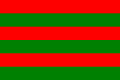 Flag of Rosendaël
 -
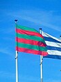 Flag of Rosendaëlsur dam


See also
- Communes of the Nord department
- Roosendael Abbey in Antwerp, Belgium
- Roosendaal, city in North Brabant, Netherlands
- Rozendaal, South Holland, town in the Netherlands
- Rozendaal, town in Gelderland, Netherlands
- Jack Rosendaal (born 1973), Dutch decathlete
References
Authority control databases | |
|---|---|
| International |
|
| National |
|
- v
- t
- e


