Rinns of Islay
Peninsula in Scotland

Lighthouse
Fl W 5s Ramsar Wetland
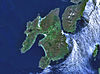
The Rinns of Islay (Scottish Gaelic: Na Roinn Ìleach; alternative English spelling Rhinns of Islay) is an area on the west of the island of Islay in the Inner Hebrides of Scotland.
It is a peninsula that is attached to the main body of the island by a narrow isthmus towards its northern end. The main population centres are Port Charlotte and Portnahaven, based on the A847 that runs along its eastern coast.
It is designated a Special Protection Area due to its importance for a number of breeding and wintering birds, particularly Greenland white-fronted goose and chough. The significance of the area owes much to its wide variety of habitats including bog, moorland, dune grassland, maritime grassland, marsh and extensively-farmed agricultural land.
The Rinns of Islay lighthouse is located on the island of Orsay.
The Rhinns complex, a deformed igneous complex that is considered to form the basement to the Colonsay Group of metasedimentary rocks takes its name from the Rhinns of Islay.
See also
 Scotland portal
 Engineering portal


References
- ^ Rowlett, Russ. "Lighthouses of Scotland: Argyll and Bute". The Lighthouse Directory. University of North Carolina at Chapel Hill. Retrieved 20 May 2016.
- ^ Rinns of Islay Northern Lighthouse Board. Retrieved 20 May 2016
- ^ "Rinns of Islay". Ramsar Sites Information Service. Retrieved 25 April 2018.
External links
Wikimedia Commons has media related to Rinns of Islay.
- Special Protection Area designation
- Northern Lighthouse Board
- Map sources for Rinns of Islay
55°44′22″N 6°26′19″W / 55.73954°N 6.43872°W / 55.73954; -6.43872
- v
- t
- e
- Ardbeg
- Ardilistry
- Ardtalla
- Ballygrant
- Bowmore
- Bridgend
- Bruichladdich
- Bunnahabhain
- Easter Ellister
- Kilchiaran
- Kilchoman
- Kilmeny
- Lagavulin
- Nerabus
- Port Askaig
- Port Charlotte
- Port Ellen
- Portnahaven
- Battle of Benbigrie
- Battle of Traigh Ghruinneart
- Battle of Epiphany
- Cenél nÓengusa
- Clan MacDonald of Dunnyveg
- Clark Cottage
- Dun Bhruichlinn
- Dun Guaidhre
- Dun Nosebridge
- Dunlossit House
- Dunyvaig Castle
- Finlaggan
- Islay Charter
- Islay House
- Islay LIMPET
- Islay Woollen Mill
- Kildalton Castle
- Kilarrow Parish Church
- RAF Kilchiaran
- Kildalton Cross
- Loch Gorm Castle
- Margadale
- Mulindry House
- Ramsay Hall, Port Ellen
- St John's Church, Port Ellen
Authority control databases | |
|---|---|
| International |
|
| Rinns of Islay Lighthouse |
|
 | This article about a Site of Special Scientific Interest in Scotland is a stub. You can help Wikipedia by expanding it. |
- v
- t
- e
 | This Argyll and Bute location article is a stub. You can help Wikipedia by expanding it. |
- v
- t
- e
 | This article about stratigraphy is a stub. You can help Wikipedia by expanding it. |
- v
- t
- e


