Mengxiu Township
Township in Yunnan, People's Republic of China
Mengxiu Township 勐秀乡 | |
|---|---|
Township | |
 Ruili Jingcheng Heliport | |
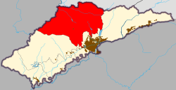 Mengxiu Township in Ruili | |
| 24°04′24″N 97°47′59″E / 24.07333°N 97.79972°E / 24.07333; 97.79972 | |
| Country | People's Republic of China |
| Province | Yunnan |
| Autonomous prefecture | Dehong Dai and Jingpo Autonomous Prefecture |
| County-level city | Ruili |
| Incorporated (township) | 1986 |
| Area | |
| • Total | 283.3 km2 (109.4 sq mi) |
| Population (2016) | |
| • Total | 11,786 |
| • Density | 42/km2 (110/sq mi) |
| Time zone | UTC+08:00 (China Standard) |
| Postal code | 678604 |
| Area code | 0692 |
Mengxiu Township (simplified Chinese: 勐秀乡; traditional Chinese: 勐秀鄉; pinyin: Měngxìu Xiāng; Tai Nuea: ᥛᥫᥒᥰ ᥞᥥᥝᥰ) is a township in Ruili, Yunnan, China. As of the 2016 statistics it had a population of 11,786 and an area of 283.3-square-kilometre (109.4 sq mi).
Etymology
The name of "Mengxiu" means a place where wild ginger grows in Dai language.
Administrative division
As of 2016, the township is divided into seven villages:
- Mengxiu (勐秀村)
- Huwa (户瓦村)
- Hulan (户兰村)
- Mengdian (勐典村)
- Dengzha (等扎村)
- Nanjingli (南京里村)
- Xiaojie (小街村)
History
In the Qing dynasty and Republic of China, the indigenous people were Jingpo people.
On 25 February 1956, the Government of Ruili County set up the Mengxiu Production and Culture Station (勐秀生产文化站) to maintain control of the region. In 1965. it came under the jurisdiction of Jiele District. During the Cultural Revolution, its name was changed to "Mengxiu People's Commune" and then "Red Flag People's Commune" (红旗公社). It was incorporated as a township in 1986.[1]
Geography
It lies at the northern of Ruili, bordering Myanmar to the northwest bounded by the Namwan River.
The highest point is Yingpan Mountain (营盘山), elevation 1,827 metres (5,994 ft).[2] The forest coverage rate of the township is 74%.[3]
Economy
The township's economy is based on agriculture.[4] The main crops are corn, rice, lemon, and walnut.[5]
Demographics
| Year | Pop. | ±% |
|---|---|---|
| 2016 | 11,786 | — |
In 2016, the local population was 11,786, including 6,190 Han (52.52%) and 4,604 Jingpo (39.06%).[6]
Tourist attractions
The Ruili Botanical Garden sits in the township.
Transportation
The China National Highway 556 passes across the township.
The Ruili Jingcheng Heliport serves the township.
References
- ^ Chen Jiang 1996, pp. 81–83.
- ^ He Wenzhong & Yang Jincai 2012, p. 109.
- ^ He Wenzhong & Yang Jincai 2012, p. 96.
- ^ He Wenzhong & Yang Jincai 2012, p. 110.
- ^ Yang Chunzheng & Yang Jincai 2017, p. 98.
- ^ Yang Chunzheng & Yang Jincai 2017, p. 96.
Bibliography
- Chen Jiang, ed. (1996). 瑞丽市志 [Annals of Ruili] (in Chinese). Chengdu: Sichuan Lexicographical Press. ISBN 7-80543-518-9.
- Yang Chunzheng; Yang Jincai, eds. (2017). 瑞丽年鉴2017 [Ruili Yearbook 2017] (in Chinese). Mangshi: Dehong Nationalities Publishing House. ISBN 978-7-5558-0866-4.
- He Wenzhong; Yang Jincai, eds. (2012). 瑞丽市志 1978–2005 [Annals of Ruili, 1978–2005] (in Chinese). Kunming: Yunnan People's Publishing House. ISBN 978-7-222-10316-0.
- v
- t
- e
Township-level divisions of Ruili (2021–present)
- Mengmao (勐卯街道)
- Huyu Township (户育乡)
- Mengxiu Township (勐秀乡)


