Manslagt
Village of Krummhörn in Lower Saxony, Germany

Coat of arms
Location of Manslagt

53°27′28″N 7°03′43″E / 53.45769°N 7.06199°E / 53.45769; 7.06199
26736
Manslagt is a village in the region of East Frisia, in Lower Saxony, Germany. It is part of the municipality of Krummhörn. The village is located between Pilsum and Groothusen.
Manslagt was historically located on an island in the former Bay of Sielmönken and was built on a warft. It was first mentioned around the 11th century.[1] The Church of Manslagt dates from around 1400.[2]
Gallery
-
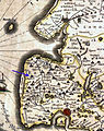 Location of Manslagt on a map by Ubbo Emmius, 1600
 -
 Houses in Manslagt
 -
 Former school, now kindergarten
 -
 Bronze model of Manslagt


Notable people
- Klaus Immer (1924–2022), politician
References
External links
![]() Media related to Manslagt at Wikimedia Commons
Media related to Manslagt at Wikimedia Commons


