List of listed buildings in Mortlach, Moray
This is a list of listed buildings in the parish of Mortlach in Moray, Scotland.
Map all coordinates using OpenStreetMap
Download coordinates as:
- KML
- GPX (all coordinates)
- GPX (primary coordinates)
- GPX (secondary coordinates)
List
| Name | Location | Date Listed | Grid Ref. [note 1] | Geo-coordinates | Notes | LB Number [note 2] | Image |
|---|---|---|---|---|---|---|---|
| Danesfield (Former Mortlach Church Of Scotland Manse) And Garden Wall | 57°26′22″N 3°07′40″W / 57.439341°N 3.127664°W / 57.439341; -3.127664 (Danesfield (Former Mortlach Church Of Scotland Manse) And Garden Wall) | Category B | 15855 |  Upload Photo | |||
| Hazelwood | 57°29′08″N 3°08′22″W / 57.485455°N 3.139377°W / 57.485455; -3.139377 (Hazelwood) | Category B | 15861 | Upload Photo | |||
| Glen Rinnes Church (Church Of Scotland), Enclosing Walls And War Memorial | 57°23′16″N 3°12′09″W / 57.387731°N 3.202503°W / 57.387731; -3.202503 (Glen Rinnes Church (Church Of Scotland), Enclosing Walls And War Memorial) | Category B | 15858 | Upload Photo | |||
| Kininvie House | 57°28′54″N 3°08′16″W / 57.481535°N 3.137687°W / 57.481535; -3.137687 (Kininvie House) | Category A | 15862 |  Upload another image | |||
| Kininvie House Dovecot | 57°28′53″N 3°08′10″W / 57.481495°N 3.136201°W / 57.481495; -3.136201 (Kininvie House Dovecot) | Category B | 15863 | Upload Photo | |||
| Tullich House | 57°28′10″N 3°07′38″W / 57.469539°N 3.127094°W / 57.469539; -3.127094 (Tullich House) | Category B | 15866 | Upload Photo | |||
| Mortlach Parish Church, (Church Of Scotland), Watch House And Burial Ground | 57°26′20″N 3°07′40″W / 57.438971°N 3.127802°W / 57.438971; -3.127802 (Mortlach Parish Church, (Church Of Scotland), Watch House And Burial Ground) | Category A | 15864 |  Upload another image | |||
| Edinglassie Mains Farmhouse | 57°26′09″N 2°57′51″W / 57.43591°N 2.964149°W / 57.43591; -2.964149 (Edinglassie Mains Farmhouse) | Category C(S) | 15856 |  Upload another image | |||
| Pittyvaich Farmhouse | 57°26′11″N 3°07′47″W / 57.436413°N 3.129589°W / 57.436413; -3.129589 (Pittyvaich Farmhouse) | Category B | 19762 |  Upload another image | |||
| Bridge Of Poolinch Over River Fiddich | 57°27′07″N 3°07′11″W / 57.451891°N 3.119618°W / 57.451891; -3.119618 (Bridge Of Poolinch Over River Fiddich) | Category C(S) | 15854 | 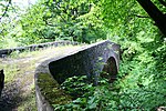 Upload another image | |||
| Edinglassie Mains Steading And Former Stables | 57°26′11″N 2°57′51″W / 57.436315°N 2.96406°W / 57.436315; -2.96406 (Edinglassie Mains Steading And Former Stables) | Category C(S) | 15857 | 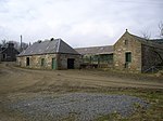 Upload another image | |||
| Glen Rinnes Lodge | 57°25′58″N 3°08′49″W / 57.43279°N 3.146867°W / 57.43279; -3.146867 (Glen Rinnes Lodge) | Category B | 15859 | Upload Photo | |||
| Hardhaugh, Mortlach | 57°26′16″N 3°07′37″W / 57.437642°N 3.126829°W / 57.437642; -3.126829 (Hardhaugh, Mortlach) | Category C(S) | 15860 | Upload Photo | |||
| Auchindoun Mill | 57°26′44″N 3°04′26″W / 57.445525°N 3.073836°W / 57.445525; -3.073836 (Auchindoun Mill) | Category B | 15853 | 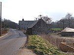 Upload another image | |||
| Parkmore Distillery, Yeast Store, Kiln, Workshops And Offices. Also Duty Free Warehouses Nos 1, 2, 4, 6, 8 | 57°27′19″N 3°07′14″W / 57.455376°N 3.120641°W / 57.455376; -3.120641 (Parkmore Distillery, Yeast Store, Kiln, Workshops And Offices. Also Duty Free Warehouses Nos 1, 2, 4, 6, 8) | Category B | 15865 | 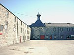 Upload another image |
Key
The scheme for classifying buildings in Scotland is:
- Category A: "buildings of national or international importance, either architectural or historic; or fine, little-altered examples of some particular period, style or building type."[1]
- Category B: "buildings of regional or more than local importance; or major examples of some particular period, style or building type, which may have been altered."[1]
- Category C: "buildings of local importance; lesser examples of any period, style, or building type, as originally constructed or moderately altered; and simple traditional buildings which group well with other listed buildings."[1]
In March 2016 there were 47,288 listed buildings in Scotland. Of these, 8% were Category A, and 50% were Category B, with the remaining 42% being Category C.[2]
See also
Notes
- ^ Sometimes known as OSGB36, the grid reference (where provided) is based on the British national grid reference system used by the Ordnance Survey.
• "Guide to National Grid". Ordnance Survey. Retrieved 12 December 2007.
• "Get-a-map". Ordnance Survey. Retrieved 17 December 2007. - ^ Historic Environment Scotland assign a unique alphanumeric identifier to each designated site in Scotland, for listed buildings this always begins with "LB", for example "LB12345".
References
- All entries, addresses and coordinates are based on data from Historic Scotland. This data falls under the Open Government Licence
- ^ a b c "What is Listing?". Historic Environment Scotland. Retrieved 29 May 2018.
- ^ Scotland's Historic Environment Audit 2016 (PDF). Historic Environment Scotland and the Built Environment Forum Scotland. pp. 15–16. Retrieved 29 May 2018.


