| Site name | Photograph | B | G | Area[a] | Public
access | Location[a] | Other
classifications | Map[b] | Citation[c] | Description |
| Alder Wood and Meadow |  |  Y Y | | 13.2 hectares
(33 acres)[13] | YES | Corby
52°27′11″N 0°46′08″W / 52.453°N 0.769°W / 52.453; -0.769 (Alder Wood and Meadow)
SP 837 846[13] | | Map | Citation | This semi-natural ancient broadleaved wood is a surviving fragment of the medieval Royal Forest of Rockingham. It is mainly ash, and the ground flora on base rich soil includes tufted hair-grass, dog's mercury and enchanter's nightshade. The meadow is agriculturally unimproved, and it has surviving medieval ridge and furrow.[14] |
| Aldwincle Marsh |  | Y | | 2.0 hectares
(4.9 acres)[15] | NO | Aldwincle
52°24′58″N 0°31′30″W / 52.416°N 0.525°W / 52.416; -0.525 (Aldwincle Marsh)
TL 004 807[15] | | Map | Citation | This marsh and fen on shallow peat is formed by seepage from the boundary between clay and limestone. Plants in wet areas include blunt-flowered rush, marsh pennywort, wild angelica and Menyanthes trifoliata, a rare species of bogbean. Drier areas have grasses and herbs which attract butterflies and dragonflies. The site includes a stretch of Harpers Brook.[16] |
| Ashton Wold |  | Y | | 54.0 hectares
(133 acres)[17] | YES | Oundle
52°28′30″N 0°23′38″W / 52.475°N 0.394°W / 52.475; -0.394 (Ashton Wold)
TL 091 875[17] | RHPG[18] | Map | Citation | Ashton Wold was owned by Charles Rothschild, the founder of The Wildlife Trusts. It is ancient secondary woodland with mature oak, ash and birch trees. The thick shrub layer includes hawthorn and buckthorn.[19] |
| Badby Wood |  | Y | | 47.2 hectares
(117 acres)[20] | YES | Badby
52°13′12″N 1°10′37″W / 52.220°N 1.177°W / 52.220; -1.177 (Badby Wood)
SP 563 582[20] | | Map | Citation | This is ancient semi-natural woodland on acidic soils, and it has been forested for over 700 years. It is mainly pedunculate oak, with varied ground flora including creeping soft-grass, wood anemone, yellow archangel and bluebell. There is also small marsh with very diverse herbs.[21] |
| Badsaddle, Withmale Park and Bush Walk Woods |  | Y | | 25.2 hectares
(62 acres)[22] | YES | Wellingborough
52°20′24″N 0°46′44″W / 52.340°N 0.779°W / 52.340; -0.779 (Badsaddle, Withmale Park and Bush Walk Woods)
SP 832 720[22] | | Map | Citation | This is ancient coppice woodland with oak and ash on wet calcareous soils. Ground flora include herb paris, goldilocks buttercup and four species of orchid.[23] |
| Banhaw, Spring and Blackthorn's Woods |  | Y | | 123.4 hectares
(305 acres)[24] | PP | Corby
52°28′48″N 0°34′16″W / 52.480°N 0.571°W / 52.480; -0.571 (Banhaw, Spring and Blackthorn's Woods)
SP 971 878[24] | | Map | Citation | These woods are one of the largest remnants of the medieval Royal Forest of Rockingham. They are mainly ash and pedunculate oak on wet calcareous clay soils. The ground flora is diverse, and there are grasses such as tufted hair-grass, rough meadow-grass and wood melick.[25] |
| Birch Spinney and Mawsley Marsh |  | Y | | 12.3 hectares
(30 acres)[26] | NO | Broughton
52°22′55″N 0°48′43″W / 52.382°N 0.812°W / 52.382; -0.812 (Birch Spinney and Mawsley Marsh)
SP 809 766[26] | | Map | Citation | Birch Spinney is a rare type of ash-maple woodland partly on peat. Mawsley Marsh is described by Natural England as "one of the finest remaining Northamptonshire marshes", with flora including blunt-flowered rush, jinted rush and water horsetail. There is also a stretch of a dismantled railway line.[27] |
| Blisworth Rectory Farm Quarry |  | | Y | 1.0 hectare
(2.5 acres)[28] | NO | Blisworth
52°10′16″N 0°57′14″W / 52.171°N 0.954°W / 52.171; -0.954 (Blisworth Rectory Farm Quarry)
SP 716 530[28] | GCR[29] | Map | Citation | This site exposes White Limestone dating to the Middle Jurassic Bathonian stage, around 168 to 166 million years ago. Common fossils are brachiopods, corals and gastropods, and there are also nautiloids and vertebrate teeth.[30] |
| Bosworth Mill Meadow |  | Y | | 5.7 hectares
(14 acres)[31] | YES | Welford
52°26′06″N 1°04′37″W / 52.435°N 1.077°W / 52.435; -1.077 (Bosworth Mill Meadow)
SP 628 822[31] | | Map | Citation | This hay meadow is traditionally managed. The main flora are crested dog's-tail and common knapweed, with meadow foxtail and great burnet in wet areas. Springs produce seepages which are rich in mosses and sedges. Dry upper slopes are species poor.[32] |
| Bozeat Meadow |  | Y | | 2.6 hectares
(6.4 acres)[33] | NO | Bozeat
52°13′19″N 0°40′55″W / 52.222°N 0.682°W / 52.222; -0.682 (Bozeat Meadow)
SP 901 590[33] | | Map | Citation | This is unimproved grassland on well-drained clay and loam soils. It has medieval ridge and furrow and diverse flora, including crested dog's-tail, downy oat-grass, quaking grass and dwarf thistle. There are also mature hedgerows and a spring.[34] |
| Bucknell Wood Meadows |  | Y | | 9.2 hectares
(23 acres)[35] | YES | Silverstone
52°05′56″N 1°03′54″W / 52.099°N 1.065°W / 52.099; -1.065 (Bucknell Wood Meadows)
SP 641 449[35] | | Map | Citation | This site consists of agriculturally unimproved fields on seasonally waterlogged soils. The flora is diverse with many herbs, including bird's-foot-trefoil, meadow buttercup and devil's-bit scabious. Variations in the types of flora are partly due to different soils and partly to previous management practices.[36] |
| Bugbrooke Meadows |  | Y | | 10.1 hectares
(25 acres)[37] | YES | Nether Heyford
52°13′23″N 1°01′05″W / 52.223°N 1.018°W / 52.223; -1.018 (Bugbrooke Meadows)
SP 671 587[37] | WTBCN[38] | Map | Citation | These meadows on the bank of the River Nene which have not been treated with fertilisers, and they often flood in winter. They are probably unique in the county, and they have very diverse damp grassland flora such as jointed rush and greater pond sedge. There are ancient hedges which are important both historically and as a habitat for wildlife.[39] |
| Bulwick Meadows |  | Y | | 1.2 hectares
(3.0 acres)[40] | PP | Bulwick
52°32′20″N 0°35′02″W / 52.539°N 0.584°W / 52.539; -0.584 (Bulwick Meadows)
SP 961 943[40] | | Map | Citation | These marshy meadows are in the flood plain of the Willow Brook. There are diverse wetland flora, including rare species, and it is the only known locality in the county for the flat-sedge blysmus compressus and common bistort. It is also one of the very few sites in the county where snipe breed.[41] |
| Calender Meadows |  | Y | | 3.1 hectares
(7.7 acres)[42] | NO | Guilsborough
52°22′05″N 0°59′42″W / 52.368°N 0.995°W / 52.368; -0.995 (Calender Meadows)
SP 685 749[42] | | Map | Citation | This is described by Natural England as "a nationally important site for its lowland unimproved neutral grassland". It has a wide variety of native herbs and grasses. There are herbs such as lady's bedstraw, meadow vetchling and common bird's-foot trefoil, and grasses include red fescue, sweet vernal-grass and false oat-grass.[43] |
| Collyweston Great Wood and Easton Hornstocks |  | Y | | 151.5 hectares
(374 acres)[44] | NO | Easton on the Hill
52°35′38″N 0°30′25″W / 52.594°N 0.507°W / 52.594; -0.507 (Collyweston Great Wood and Easton Hornstocks)
TF 012 006[44] | NCR,[45] NNR[46] | Map | Citation | These woods have ash, lime and sessile oak, together with wild service-trees, which is an indicator of ancient woodland. The ground flora is very rich, including locally unusual plants such as lily-of-the-valley, wood spurge, great wood-rush, violet helleborine and columbine.[47] |
| Collyweston Quarries |  | Y | | 6.6 hectares
(16 acres)[48] | YES | Easton on the Hill
52°37′23″N 0°31′08″W / 52.623°N 0.519°W / 52.623; -0.519 (Collyweston Quarries)
TF 003 038[48] | WTBCN[49] | Map | Citation | This former limestone quarry is now rough grassland on Jurassic limestone. The flora is diverse, and more than a hundred flowering plants have been recorded, including wild thyme, dropwort, dyer's greenweed and clustered bellflower. There is a substantial butterfly population.[50] |
| Collyweston Slate Mine |  | | Y | 0.9 hectares
(2.2 acres)[51] | NO | Easton on the Hill
52°36′58″N 0°31′26″W / 52.616°N 0.524°W / 52.616; -0.524 (Collyweston Slate Mine)
TF 000 030[51] | GCR[52] | Map | Citation | This slate mine was operated until 1963, quarrying Collyweston slate, which dates to the Jurassic. The shaft exposes a section described by Natural England as "stratigraphically important", and it is the type locality for the slate.[53] |
| Coombe Hill Hollow |  | Y | | 4.3 hectares
(11 acres)[54] | NO | Welford
52°26′46″N 1°00′11″W / 52.446°N 1.003°W / 52.446; -1.003 (Coombe Hill Hollow)
SP 678 835[54] | | Map | Citation | This steep narrow valley has neutral grassland which has never been subject to fertilisers or herbicides, and it has diverse flora. Grasses include brown bent, red fescue, Yorkshire fog and crested dog's-tail. Lime-rich areas have harebell and mouse-ear hawkweed, and there are locally important butterfly populations.[55] |
| Cowthick Quarry |  | | Y | 1.4 hectares
(3.5 acres)[56] | NO | Corby
52°28′55″N 0°38′20″W / 52.482°N 0.639°W / 52.482; -0.639 (Cowthick Quarry)
SP 925 879[56] | | Map | Citation | This site exposes Middle Jurassic rocks dating to 174 to 163 million years ago, and in the view of Natural England it has "the best and most instructive sections" of the period in the Midlands. A fault during the Pleistocene has caused the juxtaposition of six Jurassic formations.[57] |
| Cranford St John |  | | Y | 2.8 hectares
(6.9 acres)[58] | NO | Kettering
52°22′41″N 0°38′42″W / 52.378°N 0.645°W / 52.378; -0.645 (Cranford St John)
SP 923 764[58] | GCR[59] | Map | Citation | This former quarry exposes rocks from the Rutland Formation and up to nearly the top of the White Limestone Formation, dating to the Middle Jurassic Bathonian stage, 168 to 166 million years ago. The site is the type section for a freshwater clay bed which is thought to result from a widespread storm deposit.[60] |
| Dungee Corner Meadow |  | Y | | 5.1 hectares
(13 acres)[61] | NO | Bozeat
52°13′52″N 0°38′35″W / 52.231°N 0.643°W / 52.231; -0.643 (Dungee Corner Meadow)
SP 927 600[61] | | Map | Citation | This well-drained hay meadow on boulder clay is traditionally managed, and no artificial fertilisers or herbicides have been used, so it has a diverse flora. More than twenty grass species have been recorded, including sweet vernal, Yorkshire fog, sheep's fescue, quaking grass and crested dog's-tail. There is also a population of the locally rare green-winged orchid.[62] |
| Everdon Stubbs |  | Y | | 29.5 hectares
(73 acres)[63] | YES | Farthingstone
52°12′18″N 1°06′54″W / 52.205°N 1.115°W / 52.205; -1.115 (Everdon Stubbs)
SP 605 566[63] | WT[64] | Map | Citation | This woodland site has areas of acidic free-draining soil, and other damper areas. It is described by Natural England as an important site for fungi, and there is a diverse range of breeding birds. There are locally uncommon plants such as wild daffodil, orpine and bitter vetch.[65] |
| Finedon Top Lodge Quarry |  | | Y | 0.9 hectares
(2.2 acres)[66] | FP | Finedon
52°19′12″N 0°38′31″W / 52.320°N 0.642°W / 52.320; -0.642 (Finedon Top Lodge Quarry)
SP 926 699[66] | GCR[67] | Map | Citation | This site shows a complete section dating to the Rutland Formation of the Bathonian stage of the Middle Jurassic, 168 to 166 million years ago. It is the type section for the Wellingborough Member, and contains fossils of oysters and Rhynchonellida.[68] |
| Geddington Chase |  | Y | | 39.1 hectares
(97 acres)[69] | NO | Corby
52°27′11″N 0°40′12″W / 52.453°N 0.670°W / 52.453; -0.670 (Geddington Chase)
SP 904 847[69] | | Map | Citation | Geddington Chase is a surviving fragment of the medieval Royal Forest of Rockingham. Most of the Chase is commercially managed, and the SSSI is an area of semi-natural wet ash-maple woodland on Midland boulder clay. The ground flora is diverse, with plants including bluebell, dog's mercury, tufted hair-grass, and a few wild daffodils.[70] |
| Glapthorn Cow Pasture |  | Y | | 28.2 hectares
(70 acres)[71] | YES | Oundle
52°30′14″N 0°31′30″W / 52.504°N 0.525°W / 52.504; -0.525 (Glapthorn Cow Pasture)
TL 002 905[71] | WTBCN[72] | Map | Citation | This site has ash-maple woodland, and dense blackthorn scrub. It is described by Natural England as one of the most important sites in Britain for the black hairstreak butterfly, which requires a habitat of prunus species such as blackthorn. The scrub also provides nesting sites for nightingales.[73] |
| Hardwick Lodge Meadow |  | Y | | 10.0 hectares
(25 acres)[74] | YES | Wellingborough
52°19′26″N 0°46′37″W / 52.324°N 0.777°W / 52.324; -0.777 (Hardwick Lodge Meadow)
SP 834 702[74] | | Map | Citation | This unimproved grassland on boulder clay has a rich variety of flora, including many rare in the county. Crested hair-grass and salad burnet are found in drier parts, and a marshy area next to a stream has common spotted-orchid and the only population in Northamptonshire of heath spotted-orchid.[75] |
| Helmdon Disused Railway |  | Y | | 16.6 hectares
(41 acres)[76] | YES | Brackley
52°04′01″N 1°08′35″W / 52.067°N 1.143°W / 52.067; -1.143 (Helmdon Disused Railway)
SP 588 412[76] | | Map | Citation | This is Jurassic grassland, and it also has limestone spoil heaps have a very diverse floral community. Butterflies include the nationally scarce wood white and five nationally declining species. It is the only location in the county for the small blue butterfly.[77] |
| High Wood and Meadow |  | Y | | 16.5 hectares
(41 acres)[78] | YES | Daventry
52°11′17″N 1°08′10″W / 52.188°N 1.136°W / 52.188; -1.136 (High Wood and Meadow)
SP 591 547[78] | WTBCN[79] | Map | Citation | The wood is ancient and semi-natural on acid soils. It has diverse ground flora, including yellow pimpernel, hairy wood-rush and broad-leaved helleborine. The meadow is acid grassland of a type which is now uncommon, and there are also areas of neutral grassland and marsh on silty peat. There are many ant hills of the yellow meadow ant.[80] |
| Irchester Old Lodge Pit |  | | Y | 0.4 hectares
(0.99 acres)[81] | NO | Irchester
52°16′30″N 0°39′40″W / 52.275°N 0.661°W / 52.275; -0.661 (Irchester Old Lodge Pit)
SP 914 649[81] | GCR[82] | Map | Citation | This is described by Natural England as "a key Middle Jurassic locality important for the information it yields on both Bathonian environments and stratigraphy", 168 to 166 million years ago. It exposes White Limestone which has many fossils, especially molluscs.[12] |
| King's Cliffe Banks |  | Y | | 7.7 hectares
(19 acres)[83] | YES | King's Cliffe
52°33′50″N 0°30′18″W / 52.564°N 0.505°W / 52.564; -0.505 (King's Cliffe Banks)
TL 014 972[83] | | Map | Citation | This former quarry has undulating calcareous grassland which is grazed by rabbits and cattle. It has a rich variety of flora, including sheep's fescue, dwarf thistle, mouse-ear hawkweed, wild thyme and common rock-rose. There are many bryophytes and lichens.[84] |
| Mantles Heath |  | Y | | 13.7 hectares
(34 acres)[85] | YES | Daventry
52°11′31″N 1°07′37″W / 52.192°N 1.127°W / 52.192; -1.127 (Mantles Heath)
SP 597 552[85] | | Map | Citation | Most of this woodland site is on acid soil, but the western part is on calcareous and poorly drained clay, and has a diverse flora. Locally uncommon plants include wood vetch, opposite-leaved golden-saxifrage and slender St John's wort.[86] |
| Mill Crook |  | Y | | 5.9 hectares
(15 acres)[87] | YES | Towcester
52°06′36″N 0°52′19″W / 52.110°N 0.872°W / 52.110; -0.872 (Mill Crook)
SP 773 463[87] | WTBCN[88] | Map | Citation | Signs of medieval ridge and furrow still survive on this traditionally managed hay meadow on the bank of the River Tove. It has diverse flora, with grasses such as meadow foxtail and sweet vernal-grass, and herbs including great burnet and ribwort plantain.[88][89] |
| Old Sulehay Forest |  | Y | | 34.8 hectares
(86 acres)[90] | YES | King's Cliffe
52°34′26″N 0°26′02″W / 52.574°N 0.434°W / 52.574; -0.434 (Old Sulehay Forest)
TL 062 985[90] | WTBCN[91] | Map | Citation | This ancient forest has a number of different soil conditions and coppice types, and the ground flora is diverse. Abundant herbs include dog's mercury, bracken, bramble, ramsons, wood anemone and bluebells.[92] |
| Pipewell Woods |  | Y | | 85.3 hectares
(211 acres)[93] | YES | Corby
52°28′01″N 0°46′30″W / 52.467°N 0.775°W / 52.467; -0.775 (Pipewell Woods)
SP 833 861[93] | NCR[94] | Map | Citation | The woods are an example of wet ash-maple woodland, some parts in a nationally rare form. It has diverse flora including the locally rare giant bellflower, herb paris and wood speedwell. Open grassy areas provide additional habitats for birds and insects.[95] |
| Pitsford Reservoir |  | Y | | 413.1 hectares
(1,021 acres)[96] | YES | Brixworth
52°19′26″N 0°52′01″W / 52.324°N 0.867°W / 52.324; -0.867 (Pitsford Reservoir)
SP 773 701[96] | WTBCN[97] | Map | Citation | This is the largest body of water in the county, and is used by wintering wildfowl, including the northern shoveler in nationally important numbers. Over 60 species of birds breed on the site, such as the great crested grebe, little grebe, teal, kingfisher and reed warbler.[97][98] |
| Plumpton Pasture |  | Y | | 3.6 hectares
(8.9 acres)[99] | NO | Towcester
52°07′41″N 1°07′59″W / 52.128°N 1.133°W / 52.128; -1.133 (Plumpton Pasture)
SP 594 480[99] | | Map | Citation | There are medieval ridge and furrows on this unimproved meadow on clay. The drier ridge tops have many herbs, while the damp furrows are dominated by creeping bent and Yorkshire fog grasses. There are also mature hedges and a small pond.[100] |
| Racecourse Farm Fields |  | Y | | 5.0 hectares
(12 acres)[101] | NO | Easton on the Hill
52°37′34″N 0°29′53″W / 52.626°N 0.498°W / 52.626; -0.498 (Racecourse Farm Fields)
TF 017 042[101] | | Map | Citation | This former quarry is grassland on Jurassic limestone. The flora is diverse, with over thirty flowering plant species in each square metre. There are several locally rare plants, such as dodder, autumn gentian, clustered bellflower and small scabious. The sward is kept short by grazing by sheep and cattle.[102] |
| Ramsden Corner Plantation |  | Y | | 3.2 hectares
(7.9 acres)[103] | YES | Northampton
52°12′11″N 1°05′20″W / 52.203°N 1.089°W / 52.203; -1.089 (Ramsden Corner Plantation)
SP 623 564[103] | WTBCN[104] | Map | Citation | A stream runs through this valley site, which also has acidic grassland, woodland and scrub on clay and sand. Plants such as wood millet, wood-sorrel and wood vetch are indicators of ancient woodland. Opposite-leaved golden-saxifrage is found on wet slopes.[105] |
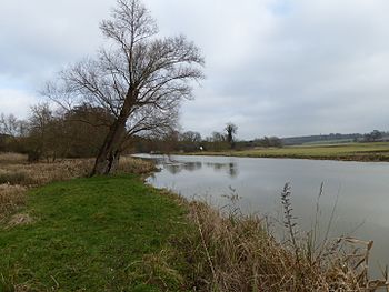
| River Ise and Meadows |  | Y | | 13.5 hectares
(33 acres)[106] | PP | Geddington
52°26′17″N 0°43′08″W / 52.438°N 0.719°W / 52.438; -0.719 (River Ise and Meadows)
SP 871 830[106] | WTBCN[107] | Map | Citation | The river is described by Natural England as "the best example in the county of a lowland river on clay, fed by base-rich water". The banks have tall fen, woodland and grassland, and there is also a species rich flood meadow. The river has many bends and loops, with silty pools and gravel shoals. The invertebrates are diverse, and there is a population of the nationally declining freshwater crayfish Austropotamobius pallipes.[108] |
| Roade Cutting |  | | Y | 15.2 hectares
(38 acres)[109] | NO | Roade
52°09′58″N 0°54′22″W / 52.166°N 0.906°W / 52.166; -0.906 (Roade Cutting)
SP 749 525[109] | GCR[110] | Map | Citation | The cutting exposes rocks dating to the Middle Jurassic Bathonian stage, between 168 and 166 million years ago. It is described by Natural England as important for reconstructing the environment of deposition during the period, and correlating the White Limestone Formation in Oxfordshire with that of the East Midlands.[111] |
| Salcey Forest |  | Y | | 159.6 hectares
(394 acres)[112] | YES | Hartwell
52°09′07″N 0°49′05″W / 52.152°N 0.818°W / 52.152; -0.818 (Salcey Forest)
SP 809 510[112] | | Map | Citation | This large forest has many mature oak trees. The diverse ground flora includes bluebells, false brome, pendulous sedge and enchanter's nightshade. There are many breeding birds and nationally notable moth species.[113] |
| Short Wood |  | Y | | 25.3 hectares
(63 acres)[114] | YES | Oundle
52°30′40″N 0°30′18″W / 52.511°N 0.505°W / 52.511; -0.505 (Short Wood)
TL 015 913[114] | WTBCN[115] | Map | Citation | Short Wood is a small remnant of the medieval royal hunting Royal Forest of Rockingham. It is ancient semi-natural woodland with the dominant trees being ash and pedunculate oak. Flora include several local rarities such as wood speedwell, bird's nest orchid and greater butterfly orchid.[116] |
| Southfield Farm Marsh |  | Y | | 8.6 hectares
(21 acres)[117] | PP | Kettering
52°22′26″N 0°42′07″W / 52.374°N 0.702°W / 52.374; -0.702 (Southfield Farm Marsh)
SP 884 758[117] | WTBCN[118] | Map | Citation | This wetland site has tall plants such as lesser pond-sedge and slender tufted-sedge, which provides cover for reed buntings and sedge warblers. Mammals include otters, and there are birds such as red kites and buzzards. Purple loosestrife is found in grassland areas.[118] |
| Stoke and Bowd Lane Woods |  | Y | | 36.4 hectares
(90 acres)[119] | PP | Corby
52°28′12″N 0°49′12″W / 52.470°N 0.820°W / 52.470; -0.820 (Stoke and Bowd Lane Woods)
SP 802 864[119] | WTBCN[120] | Map | Citation | These ancient semi-natural woods were formerly part of the medieval Royal Forest of Rockingham. The main tree species is pedunculate oak, with other species such as ash and birch. Ground flora include herb paris, wood sorrel, yellow archangel, early-purple orchid and greater butterfly-orchid.[121] |
| Sudborough Green Lodge Meadows |  | Y | | 13.6 hectares
(34 acres)[122] | NO | Sudborough
52°26′49″N 0°34′23″W / 52.447°N 0.573°W / 52.447; -0.573 (Sudborough Green Lodge Meadows)
SP 970 841[122] | NCR[123] | Map | Citation | This site consists of two hay meadows, one of which is agriculturally unimproved and has large areas of medieval ridge and furrow. An experiment in trying to create attractive grasslands in the other field has potential for scientific research. Ponds, scrub, willow trees, hedgerows and wild pear trees add to the ecological value.[123] |
| Syresham Marshy Meadows |  | Y | | 17.8 hectares
(44 acres)[124] | PP | Silverstone
52°04′41″N 1°04′01″W / 52.078°N 1.067°W / 52.078; -1.067 (Syresham Marshy Meadows)
SP 640 425[124] | | Map | Citation | This site consists of two nearby areas of wetland in valleys which drain into the River Great Ouse. The northern one is a mire on shallow peat, and the southern one is agriculturally unimproved grassland and marsh on diverse soils, which has over a hundred flowering plant species.[125] |
| Thrapston Station Quarry |  | | Y | 4.5 hectares
(11 acres)[126] | NO | Thrapston
52°23′17″N 0°31′59″W / 52.388°N 0.533°W / 52.388; -0.533 (Thrapston Station Quarry)
SP 999 776[126] | GCR[127] | Map | Citation | This site has the most important remaining Middle Jurassic Cornbrash geological section in the Midlands. It is the type site for the Bathonian Blisworth Clay section, dating to 168 to 166 million years ago, and it has the only complete exposure of this section. Diagnostic ammonites have helped to date the site, which has also yielded important Bryozoan fossils.[128][129] |
| Titchmarsh Meadow |  | Y | | 2.2 hectares
(5.4 acres)[130] | NO | Titchmarsh
52°24′18″N 0°29′13″W / 52.405°N 0.487°W / 52.405; -0.487 (Titchmarsh Meadow)
TL 030 796[130] | | Map | Citation | This poorly drained field has a rich variety of plant species, including greater bird's-foot-trefoil, southern marsh-orchid and pepper saxifrage. A medieval fish pond, which has been drained, has marsh vegetation. Hedges, streams and ditches provide a valuable habitat for invertebrates and small mammals.[131] |
| Twywell Gullet |  | Y | | 17.1 hectares
(42 acres)[132] | PP | Kettering
52°23′17″N 0°36′50″W / 52.388°N 0.614°W / 52.388; -0.614 (Twywell Gullet)
SP 944 775[132] | WTBCN[133] | Map | Citation | Twywell Gullet is a former ironstone quarry which has deep cuttings with steeply sloping banks. It has species-rich limestone grassland on the slopes and ponds and scrub in the bottoms. There are a number of uncommon ground nesting bees and wasps, and beetles include the nationally rare ruddy darter.[134] |
| Upper Cherwell at Trafford House |  | | Y | 18.6 hectares
(46 acres)[135] | YES | Eydon
52°08′06″N 1°13′44″W / 52.135°N 1.229°W / 52.135; -1.229 (Upper Cherwell At Trafford House)
SP 528 488[135] | GCR[136] | Map | Citation | This site is at the confluence of the River Cherwell and Eydon Brook. They are underfit streams, which have channels which are small for the size of their valleys. According to Natural England, the site has played an important role in the development of the theory of underfit streams. Deposits in a paleochannel could enable reconstruction of the environmental history.[137] |
| Upper Nene Valley Gravel Pits |  | Y | | 1,382.4 hectares
(3,416 acres)[138] | PP | Rushden
52°18′50″N 0°38′20″W / 52.314°N 0.639°W / 52.314; -0.639 (Upper Nene Valley Gravel Pits)
SP 928 693[138] | LNR,[139][140] Ramsar,[10] SPA,[11] WTBCN[138][141][142] | Map | Citation | This site is described by Natural England as "a nationally important site for its breeding bird assemblage of lowland open waters and their margins". There are at least 21 breeding bird species, including mute swans, tufted ducks, little grebes, great crested grebes, little ringed plovers and redshanks.[143] |
| Wadenhoe Marsh and Achurch Meadow |  | Y | | 47.5 hectares
(117 acres)[144] | PP | Oundle
52°25′59″N 0°31′01″W / 52.433°N 0.517°W / 52.433; -0.517 (Wadenhoe Marsh and Achurch Meadow)
TL 009 826[144] | | Map | Citation | This complex site on both sides of the River Nene has a variety of habitats and a diverse range of fauna and flora. The west of the river is alder woodland and marshy grassland. On the east there is the largest example in the county of unimproved grassland on alluvium and gravel, with over 100 flowering plant species. An oxbow in the river is a site for rare plants.[145] |
| Wakerley Spinney |  | Y | | 4.4 hectares
(11 acres)[146] | NO | King's Cliffe
52°34′37″N 0°34′37″W / 52.577°N 0.577°W / 52.577; -0.577 (Wakerley Spinney)
SP 965 986[146] | | Map | Citation | This is a remnant of the medieval Royal Forest of Rockingham, and it has broadleaved woodland and semi-natural grassland. The most common trees are pedunculate oak, ash, sycamore and downy birch. Locally uncommon flowering plants include woodruff, violet helleborine and fly orchid.[147] |
| Weldon Park |  | Y | | 51.7 hectares
(128 acres)[148] | NO | Weldon
52°30′00″N 0°36′25″W / 52.500°N 0.607°W / 52.500; -0.607 (Weldon Park)
SP 946 900[148] | | Map | Citation | This ancient woodland is mainly ash trees, maple and hazel. It has diverse flora, especially on grassland rides, and unusual plants on the wettest soils. Insects include the uncommon purple emperor butterfly.[149] |
| Whittlewood Forest |  | Y | | 400.1 hectares
(989 acres)[150] | PP | Silverstone
52°04′52″N 0°56′56″W / 52.081°N 0.949°W / 52.081; -0.949 (Whittlewood Forest)
SP 721 430[150] | NCR[94] | Map | Citation | This is ancient semi-natural woodlands with many trees which are mature or over-mature, especially pedunculate oaks. There are also many ash trees and a scattering of silver birches and aspens. The oaks have nationally rare and nationally uncommon beetles, and there are locally rare lichens.[151] |
| Wollaston Meadows |  | Y | | 14.3 hectares
(35 acres)[152] | NO | Wellingborough
52°16′26″N 0°41′10″W / 52.274°N 0.686°W / 52.274; -0.686 (Wollaston Meadows)
SP 897 648[152] | | Map | Citation | This site on the banks of the River Nene is composed of two species-rich hay fields. Flora include meadow foxtail, crested dog's-tail and red fescue. Overgrown hedges and ditches provide habitats for birds, small mammals and invertebrates.[153] |
| Yardley Chase |  | Y | | 357.6 hectares
(884 acres)[154] | PP | Yardley Hastings
52°10′52″N 0°45′47″W / 52.181°N 0.763°W / 52.181; -0.763 (Yardley Chase)
SP 846 543[154] | | Map | Citation | The Chase has diverse semi-natural habitats, and its value for invertebrates has been enhanced by military use of the site, which has resulted in a long absence of intensive agriculture. There is woodland and unimproved grassland, and 30 breeding butterfly species have been recorded.[155] |