Korbeek-Lo, Leuven
Suburb of the city of Leuven, Belgium
Part of Leuven in Flemish Community, Belgium
Location of Korbeek-Lo

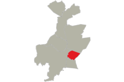
Location of Korbeek-Lo in Leuven
50°52′00″N 4°44′00″E / 50.86667°N 4.73333°E / 50.86667; 4.73333
 Belgium
 Flemish Community Flemish Region
 Flemish Brabant
 (2012-01-01)
3000

The western part of the former municipality of Korbeek-Lo (Dutch pronunciation: [ˈkɔrbeːkˌloː]) is now a part of the city of Leuven, Belgium. According to the official website of Leuven, Korbeek-Lo is a part of the sub-municipality of Leuven.[1]
As a result of extensive local government boundary changes in 1977 Korbeek-Lo, as a municipality, was abolished. Since then the more built up western part of Korbeek-Lo has been subsumed into Leuven while the more rural eastern part of the former municipality is now part of Bierbeek.[2]
References
Wikimedia Commons has media related to Korbeek-Lo (Leuven).
- v
- t
- e
Populated places in Leuven
villages and hamlets
- Egenhoven
- Haasrode
- Korbeek-Lo
- Nieuw Kwartier
- Terbank
 | This Flemish Brabant location article is a stub. You can help Wikipedia by expanding it. |
- v
- t
- e


