Khunti district
District of Jharkhand in India
Khunti district | |
|---|---|
District of Jharkhand | |
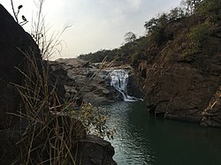 Perua Gagh falls | |
 Location of Khunti district in Jharkhand | |
| Country |  India India |
| State |  Jharkhand Jharkhand |
| Division | South Chotanagpur |
| Headquarters | Khunti |
| Government | |
| • Deputy Commissioner | Shri. Shashi Ranjan, IAS |
| • Lok Sabha constituencies | Khunti (shared with Simdega, Ranchi and Seraikela Kharsawan districts) |
| • Vidhan Sabha constituencies | 3 |
| Area | |
| • Total | 2,535 km2 (979 sq mi) |
| Population (2011) | |
| • Total | 531,885 |
| • Density | 210/km2 (540/sq mi) |
| Demographics | |
| • Literacy | 63.86% |
| • Sex ratio | 994 |
| Time zone | UTC+05:30 (IST) |
| Vehicle registration | JH-23 |
| Website | khunti |
Khunti district is one of the twenty-four districts in South Chotanagpur division of the Indian state of Jharkhand. The district of Khunti was carved out of Ranchi district on 12 September 2007. As of 2011[update], it is the second least populous district of Jharkhand (out of 24), after Lohardaga.[1] Khunti town is the headquarters of the district. It is historically known as the birthplace of Birsa Munda, and being the centre of activity of the Birsa movement. It is the part of State Capital Region (SCR). [2][3]
The district is currently a part of the Red Corridor.[4]
History
In ancient site of Saridkel, burnt bricks houses, red ware pottery, copper tools, coins and iron tools found which are belongs to early centuries CE.[5]
Administration
Blocks/Mandals
Khunti district has one sub-division and 6 blocks. The Deputy Commissioner (DC) of Khunti district is Mr.Suraj Kumar IAS. Khunti sub-division is the only sub-disvision in the district headed by the Sub-Divisional Magistrate(SDM) Mr. Pranav Kumar Pal. Khunti district has six community development blocks:
Demographics
| Year | Pop. | ±% |
|---|---|---|
| 1901 | 155,506 | — |
| 1911 | 181,651 | +16.8% |
| 1921 | 174,763 | −3.8% |
| 1931 | 205,234 | +17.4% |
| 1941 | 219,412 | +6.9% |
| 1951 | 243,744 | +11.1% |
| 1961 | 270,551 | +11.0% |
| 1971 | 309,590 | +14.4% |
| 1981 | 334,112 | +7.9% |
| 1991 | 386,330 | +15.6% |
| 2001 | 434,819 | +12.6% |
| 2011 | 531,885 | +22.3% |
| Source: Census of India[6] | ||
| Religions in Khunti district (2011)[7] | ||||
|---|---|---|---|---|
| Religion | Percent | |||
| Sarna | 45.37% | |||
| Hinduism | 26.11% | |||
| Christianity | 25.65% | |||
| Islam | 2.47% | |||
| Other or not stated | 0.41% | |||
As of 2011[update] census of India, Khunti district has a population of 531,885,[1] roughly equal to the nation of Cape Verde.[8] This gives it a ranking of 541st in India (out of a total of 640).[1] The district has a population density of 210 inhabitants per square kilometre (540/sq mi).[1] Its population growth rate over the decade 2001-2011 was 21.96%.[1] Khunti has a sex ratio of 994 females for every 1000 males,[1] and a literacy rate of 63.86%. 8.46% of the population lives in urban areas. Scheduled Castes and Scheduled Tribes collectively account for 77.77% (SC 4.52% and ST 73.25%)[1] of the district's total population. The prominent communities in this group, in terms of the district's total population, was Munda (61.28%), Oraon (6.24%), Lohra (2.82%), Ghasi (1.46%), Pan/Sawasi (0.96%), Bhogta (0.85%), Chik Baraik (0.48%), Mahli (0.34%), Turi (0.3%), and Dhobi (0.22%). Additionally, communities such as Dom, Binjhia, Chamar/Mochi, Santal, Bhuiya, Bedia, Kharia, Kharwar, Kora, Gorait, Ho, and Musahar also has populations ranging between one thousand to a hundred.[9]
At the time of the 2011 Census of India, 61.72% of the population in the district spoke Mundari, 27.79% Sadri, 5.78% Hindi and 2.90% Kurmali as their first language.[10]
Local places
Panchghagh waterfall has 5 streams to it. The Banai River branches itself out in five different streams, generating rivulets through the cluster of rocks.[citation needed]
Anganbari –Shiva Temple is a religious center of the district known for its Shiva Temple. Every year during Sawan season local festival is celebrate for one month long. On Maha-shivratri Day, temple is visited by many disciples from different regions of Jharkhand. It is located on Khunti-Torpa road 9 km from the district headquarters.[citation needed]
Dombari Buru rises above Sail Rakab village close to Ulihatu. It is in the hills of Dombari Buru where Birsa Munda led his legendary ulgulan (rebellion) against the British more than a century ago. It is located 50 km from the state capital.
Politics
This section is transcluded from 5th Jharkhand Assembly. (edit | history)
| District | No. | Constituency | Name | Party | Alliance | Remarks | ||
|---|---|---|---|---|---|---|---|---|
| Khunti | 59 | Torpa | Koche Munda | Bharatiya Janata Party | NDA | |||
| 60 | Khunti | Nilkanth Singh Munda | Bharatiya Janata Party | NDA | ||||
References
- ^ a b c d e f g "District Census Handbook: Khunti" (PDF). censusindia.gov.in. Registrar General and Census Commissioner of India. 2011.
- ^ Birsa Mumda commemorative postage stamp and biography India Post, 15 November 1988.
- ^ "Jharkhand Police". Retrieved 2009-03-10. [dead link]
- ^ "83 districts under the Security Related Expenditure Scheme". IntelliBriefs. 2009-12-11. Archived from the original on 2011-10-27. Retrieved 2011-09-17.
- ^ "Asura Site Saridkhel". asiranchicircle. Retrieved 11 October 2022.
- ^ "Table A-02 Decadal Variation in Population Since 1901: Jharkhand" (PDF). census.gov.in. Registrar General and Census Commissioner of India.
- ^ "Table C-01 Population By Religion: Jharkhand". census.gov.in. Registrar General and Census Commissioner of India.
- ^ US Directorate of Intelligence. "Country Comparison:Population". Archived from the original on June 13, 2007. Retrieved 2011-10-01.
Cape Verde 516,100 July 2011 est.
- ^
- "A-10 Appendix: District wise scheduled caste population (Appendix), Jharkhand - 2011". Office of the Registrar General & Census Commissioner, India.
- "A-11 Appendix: District wise scheduled tribe population (Appendix), Jharkhand - 2011". Office of the Registrar General & Census Commissioner, India.
- ^ a b "Table C-16 Population by Mother Tongue: Jharkhand". censusindia.gov.in. Registrar General and Census Commissioner of India.
External links
- Official website
- Tourism guide of jharkhand state, more about khunti
- Ranchi Talk
- Hundru Fall - The 2nd Highest WaterFall of Jharkhand, more about Hundru Falls
- v
- t
- e


and
Districts
| Palamu | |
|---|---|
| North Chotanagpur | |
| South Chotanagpur | |
| Kolhan | |
| Santhal Pargana |
23°04′12″N 85°16′48″E / 23.07000°N 85.28000°E / 23.07000; 85.28000


