Joypur, Bankura
Village in West Bengal, India
23°02′51″N 87°26′48″E / 23.0474°N 87.4467°E / 23.0474; 87.4467 India
India (2011)
722138 (Joypur)
Joypur (also spelled Jaypur, Jaipur) is a village, with a police station, in the Joypur CD block in the Bishnupur subdivision of the Bankura district in the state of West Bengal, India.
Geography


8km
5miles
5miles
River
Dwarakeswar
Damodar River
Madanmohanpur
T

Patit Dommahal
T
Maynapur
T
Hadal Narayanpur
TV
Gumut
T
Gokulnagar
T
Dwadashbari
T
Balsi
Purbapara
Purbapara
T
Baital
T
Akui
T
Dihar
T
Dharapat
T
Kotulpur
CT
Sonamukhi
M
Bishnupur
M
Joykrishnapur
R
Laugram
R
Ajodhya
R
Radhanagar
R
Patrasayer
R
Jayrambati
R
Joypur
R
Indas
R
Chatra
R
Bhara
R
Places in Bishnupur subdivision in Bankura district
M: Municipal town, CT: census town, R: rural/ urban centre, T: ancient/ temple centre
Owing to space constraints in the small map, the actual locations in a larger map may vary slightly
M: Municipal town, CT: census town, R: rural/ urban centre, T: ancient/ temple centre
Owing to space constraints in the small map, the actual locations in a larger map may vary slightly
Location
Joypur is located at 23°02′51″N 87°26′48″E / 23.0474°N 87.4467°E / 23.0474; 87.4467.
Area overview
The map alongside shows the Bishnupur subdivision of Bankura district. Physiographically, this area has fertile low lying alluvial plains.[1] It is a predominantly rural area with 90.06% of the population living in rural areas and only 8.94% living in the urban areas.[2] It was a part of the core area of Mallabhum.[3]
Note: The map alongside presents some of the notable locations in the subdivision. All places marked in the map are linked in the larger full screen map.
Civic administration
Police station
Joypur police station has jurisdiction over Joypur CD block. The area covered is 262.74 km2 with a population of 139,693.[4][5]
CD block HQ
The headquarters of Joypur CD block are located at Joypur.[6]
Demographics
According to the 2011 Census of India, Joypur had a total population of 3,136 of which 1,588 (51%) were males and 1,548 (49%) were females. Population below 6 years was 317. The total number of literates in Joypur was 2,173 (77.08% of the population over 6 years).[7]
Education
- Joypur B.Ed. College is a private non-aided college. It is affiliated to the Baba Saheb Ambedkar Education University and offers courses leading to the Bachelor of Education degree.[8][9]
- Joypur High School is a Bengali-medium coeducational institution established in 1962.[10]
- Joypur Madhyamik Balika Vidyalaya is a Bengali-medium girls only institution established in 2000.[11]
Healthcare
Joypur Block Primary Health Centre, with 15 beds at Joypur, is the major government medical facility in the Joypur CD block. There are primary health centres at Hijaldiha (with 10 beds), Uttarbar (Magura) (with 10 beds), Hetia (panchayat management) (with 6 beds) and Jagannathpur (with 10 beds).[12][13]
Transport
State Highway 2 (West Bengal) running from Bankura to Malancha (in North 24 Parganas district) passes through Joypur.[14]
Gallery
-
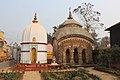 Deul and atchala temple
 -
 Depara Navaratna temple
 -
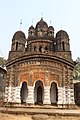 Duttapara Navaratna temple
 -
 Highway at Joypur forest range
 -
 Joypur forest inside
 -
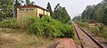 Birshamunda Halt railway station at Joypur, Bankura
 -
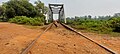 Basudebpur canal bridge in Joypur
 -
 Abandoned US army airfield at Jaypur


References
- ^ "District Census Handbook Bankura" (PDF). pages 13-17. Directorate of Census Operations West Bengal. Retrieved 23 April 2020.
- ^ "District Statistical Handbook 2014 Bankura". Table 2.4b. Department of Statistics and Programme Implementation, Government of West Bengal. Retrieved 23 April 2020.[permanent dead link]
- ^ O'Malley, L.S.S., ICS, Bankura, Bengal District Gazetteers, pp. 21–46, 1995 reprint, first published 1908, Government of West Bengal
- ^ "District Statistical Handbook 2014 Bankura". Tables 2.1, 2.2. Department of Statistics and Programme Implementation, Government of West Bengal. Retrieved 15 May 2020.
- ^ "Joypur PS". Bankura District Police. Retrieved 14 October 2016.
- ^ "District Census Handbook: Bankura" (PDF). Map of Bankura with CD block HQs and Police Stations (on the fifth page). Directorate of Census Operations, West Bengal, 2011. Retrieved 20 November 2016.
- ^ "2011 Census – Primary Census Abstract Data Tables". West Bengal – District-wise. Registrar General and Census Commissioner, India. Retrieved 14 October 2016.
- ^ "Joypur B.Ed. College". University of Burdwan. Archived from the original on 20 December 2016. Retrieved 1 December 2016.
- ^ "Joypur B.Ed. College". College Admission. Retrieved 1 December 2016.
- ^ "Joypur HS". Schools.org.in. Retrieved 4 May 2020.
- ^ "Joypur Madhyamik B. Vidyalaya (High School)". Schools.org.in. Retrieved 4 May 2020.
- ^ "Health & Family Welfare Department" (PDF). Health Statistics – Rural Hospitals. Government of West Bengal. Retrieved 10 April 2020.
- ^ "Health & Family Welfare Department" (PDF). Health Statistics – Primary Health Centres. Government of West Bengal. Retrieved 10 April 2020.
- ^ "List of State Highways in West Bengal". West Bengal Traffic Police. Retrieved 15 October 2016.
External links
 Media related to Joypur, Bankura at Wikimedia Commons
- v
- t
- e
Cities, towns and locations in Bankura District, Medinipur division
and census towns
| Bankura Sadar subdivision | |
|---|---|
| Bishnupur subdivision | |
| Khatra subdivision |

other than cities and towns
| Bankura Sadar subdivision | |
|---|---|
| Bishnupur subdivision | |
| Khatra subdivision |
 Bankura topics
 People from Bankura district
- Villages in Bankura district


 India portal


