Huating, Gansu
County-level city in Gansu, China
Huating 35°13′N 106°36′E / 35.217°N 106.600°E / 35.217; 106.600 | |
|---|---|
| Country | China |
| Province | Gansu |
| Prefecture-level city | Pingliang |
| Municipal seat | Donghua Town |
| Area | |
| • Total | 1,183 km2 (457 sq mi) |
| Elevation | 1,300 m (4,300 ft) |
| Population (2020 census)[1] | |
| • Total | 182,449 |
| • Density | 150/km2 (400/sq mi) |
| Time zone | UTC+8 (China Standard) |
| Postal code | 744100 |
| Website | www |
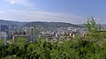
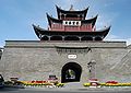
Huating (simplified Chinese: 华亭; traditional Chinese: 華亭; pinyin: Huátíng) is a county-level city, formerly Huating County, in the east of Gansu province, China, bordering Ningxia to the northwest. It is under the administration of the Pingliang City. Its postal code is 744100, and in 1999 its population was 176,941 people.
Huating was first established in 605 CE. It is named after Huajian Mountain (华尖山). In 2018 Huating County was upgraded to Huating county-level city.[2]
Huating has long been a center of coal mining and porcelain production in Gansu. In 2006 it produced over 14 million tons of coal. The agriculture output of Huating is centered around walnuts, medicinal plants, in particular Ligusticum striatum, and beef cattle.[3][4]
In July 2010 13 people died in Huating County in a landslide triggered by heavy rains. Two people survived.[5]
Administrative divisions
Huating City is divided to 1 subdistricts, 7 towns, 3 townships and 1 others.[6]
- Subdistricts
- Donghua Subdistrict (东华街道)
- Towns
|
|
- Townships
- Shenyu Township (神峪乡)
- Shanzhai Township(山寨乡)
- Yanxia Township (砚峡乡)
- Others
- Shibaozi Development Zone Management Committee(石堡子开发区管委会)
Climate
| Climate data for Huating (1991–2020 normals, extremes 1981–2010) | |||||||||||||
|---|---|---|---|---|---|---|---|---|---|---|---|---|---|
| Month | Jan | Feb | Mar | Apr | May | Jun | Jul | Aug | Sep | Oct | Nov | Dec | Year |
| Record high °C (°F) | 16.0 (60.8) | 22.1 (71.8) | 27.2 (81.0) | 31.0 (87.8) | 32.6 (90.7) | 34.0 (93.2) | 35.0 (95.0) | 33.0 (91.4) | 33.6 (92.5) | 26.3 (79.3) | 21.9 (71.4) | 17.9 (64.2) | 35.0 (95.0) |
| Mean daily maximum °C (°F) | 2.1 (35.8) | 5.0 (41.0) | 10.8 (51.4) | 17.3 (63.1) | 21.4 (70.5) | 25.1 (77.2) | 26.2 (79.2) | 24.5 (76.1) | 19.6 (67.3) | 14.4 (57.9) | 9.2 (48.6) | 3.7 (38.7) | 14.9 (58.9) |
| Daily mean °C (°F) | −5.6 (21.9) | −2.0 (28.4) | 3.7 (38.7) | 10.0 (50.0) | 14.5 (58.1) | 18.5 (65.3) | 20.5 (68.9) | 19.1 (66.4) | 14.3 (57.7) | 8.3 (46.9) | 1.8 (35.2) | −4.0 (24.8) | 8.3 (46.9) |
| Mean daily minimum °C (°F) | −11.0 (12.2) | −7.0 (19.4) | −1.7 (28.9) | 3.3 (37.9) | 7.6 (45.7) | 11.9 (53.4) | 15.2 (59.4) | 14.5 (58.1) | 10.1 (50.2) | 3.8 (38.8) | −3.0 (26.6) | −9.0 (15.8) | 2.9 (37.2) |
| Record low °C (°F) | −23.9 (−11.0) | −21.3 (−6.3) | −15.5 (4.1) | −8.0 (17.6) | −3.7 (25.3) | 2.4 (36.3) | 6.9 (44.4) | 4.9 (40.8) | −0.5 (31.1) | −9.6 (14.7) | −16.8 (1.8) | −30.2 (−22.4) | −30.2 (−22.4) |
| Average precipitation mm (inches) | 5.6 (0.22) | 7.8 (0.31) | 17.7 (0.70) | 30.6 (1.20) | 55.7 (2.19) | 80.9 (3.19) | 118.4 (4.66) | 119.4 (4.70) | 94.0 (3.70) | 48.1 (1.89) | 13.7 (0.54) | 2.8 (0.11) | 594.7 (23.41) |
| Average precipitation days (≥ 0.1 mm) | 4.8 | 5.7 | 6.9 | 7.3 | 10.1 | 10.8 | 13.4 | 13.1 | 13.3 | 11.1 | 5.8 | 2.9 | 105.2 |
| Average snowy days | 8.5 | 8.9 | 6.0 | 1.1 | 0 | 0 | 0 | 0 | 0 | 0.7 | 5.0 | 6.4 | 36.6 |
| Average relative humidity (%) | 65 | 66 | 64 | 60 | 64 | 69 | 76 | 80 | 83 | 80 | 74 | 67 | 71 |
| Mean monthly sunshine hours | 166.2 | 150.8 | 177.2 | 201.9 | 217.1 | 210.2 | 201.1 | 181.9 | 140.9 | 146.4 | 162.7 | 173.0 | 2,129.4 |
| Percent possible sunshine | 53 | 48 | 47 | 51 | 50 | 48 | 46 | 44 | 38 | 42 | 53 | 57 | 48 |
| Source: China Meteorological Administration[7][8] | |||||||||||||
See also
References
- ^ "平凉市第七次全国人口普查公报" (in Chinese). Government of Pingliang. 2021-05-27.
- ^ "华亭县撤县设立县级华亭市". www.gansu.gov.cn. Retrieved 2021-04-28.
- ^ "甘肃省平凉市华亭市地名介绍". www.tcmap.com.cn. Retrieved 2021-04-28.
- ^ "川芎".
- ^ "13 die in northwest China landslide". People's Daily. Xinhua. July 24, 2010. Retrieved 2016-10-13.
- ^ "统计用区划代码 www.stats.gov.cn" (in Chinese). XZQH. Retrieved 2020-12-27.
- ^ 中国气象数据网 – WeatherBk Data (in Simplified Chinese). China Meteorological Administration. Retrieved 24 September 2023.
- ^ 中国气象数据网 (in Simplified Chinese). China Meteorological Administration. Retrieved 24 September 2023.
- Harvard University Committee on the Environment (1999). "China County & City Population 1999 FAQ". Archived from the original on 2016-01-09.
Largest cities in Gansu Source: China Urban Construction Statistical Yearbook 2018 Urban Population and Urban Temporary Population | ||||||||||||||||||||||||||||||||||||||||||||||||||||||||||||||
|---|---|---|---|---|---|---|---|---|---|---|---|---|---|---|---|---|---|---|---|---|---|---|---|---|---|---|---|---|---|---|---|---|---|---|---|---|---|---|---|---|---|---|---|---|---|---|---|---|---|---|---|---|---|---|---|---|---|---|---|---|---|---|
| ||||||||||||||||||||||||||||||||||||||||||||||||||||||||||||||


 | This Gansu location article is a stub. You can help Wikipedia by expanding it. |
- v
- t
- e


