Hobsons Bay
Bay in Victoria, Australia
| Hobsons Bay | |
|---|---|
 Hobsons Bay Yacht Club 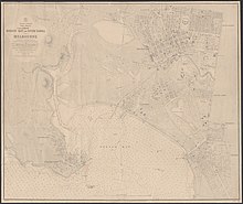 | |
| 37°51′17″S 144°56′09″E / 37.85472°S 144.93583°E / -37.85472; 144.93583[1] | |
| Primary inflows | Yarra River |
| Primary outflows | Port Phillip |
| Basin countries | Australia |
| Frozen | never |
| Settlements | Port Melbourne; Williamstown |
Hobsons Bay is a small open bay in Victoria, Australia, and is the northernmost part of the larger Port Phillip Bay. Its western and eastern boundaries are marked by Point Gellibrand in Williamstown and Point Ormond in Elwood respectively, and defines the coastal margin of the Melbourne suburbs of Wiliamstown, Newport, Port Melbourne, Albert Park, Middle Park, St. Kilda West, St. Kilda and Elwood. The Yarra River flows into Hobsons Bay.
Hobsons Bay is named after William Hobson who led the surveying party in Port Philip Bay.


Beaches
Beaches adjoining the bay are Sandridge Beach (in Port Melbourne), Port Melbourne Beach (in Port Melbourne), South Melbourne Beach (in Albert Park), West Beach (in St Kilda West) and St Kilda Beach (in St Kilda).
See also
References
- ^ "Hobsons Bay (VIC)". Gazetteer of Australia online. Geoscience Australia, Australian Government.
- v
- t
- e
Coastal bays and inlets of Victoria, Australia
- Anderson
- Apollo
- Beaumaris
- Corio
- Corner
- Daveys
- Dinosaur
- Discovery
- Half Moon
- Hobsons
- Limeburners
- Port Phillip
- Portland
- Shallow
- Swan
- Waratah
- Western Port
- Bay of Islands Coastal Park
- Port Phillip Bay (Western Shoreline) and Bellarine Peninsula Ramsar Site
- Swan Bay and Port Phillip Bay Islands Important Bird Area
 Category

 | This article about a place in Melbourne is a stub. You can help Wikipedia by expanding it. |
- v
- t
- e


