Hazerswoude-Rijndijk
Village in South Holland, Netherlands
52°7′45″N 4°35′35″E / 52.12917°N 4.59306°E / 52.12917; 4.59306 (2021)[1]
2394[1]
Hazerswoude-Rijndijk is a Dutch village located in the province of South Holland. It is a part of the municipality of Alphen aan den Rijn, and lies about 5 km west of the village center.
Hazerswoude-Rijndijk is a peat excavation settlement which developed in the Middle Ages south of the Oude Rijn.[3]
The Catholic St Bernardus Church is a single aisled church built between 1854 and 1855.[3] The polder mill Groenendijkse Molen was built in 1627 as a wooden windmill. It was considered for replacement by a stone windmill several times. An electric pumping station was installed in 1959. In 1966, the windmill was bought by a foundation and restored to working order. It operates on a voluntary basis.[4]
Gallery
-
 St Bernardus Church
 -
 Water tower
 -
 Polder mill Groenendijkse Molen
 -
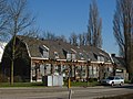 Houses in Hazerswoude-Rijndijk


References
- ^ a b c "Kerncijfers wijken en buurten 2021". Central Bureau of Statistics. Retrieved 2 May 2022.
- ^ "Postcodetool for 2394AA". Actueel Hoogtebestand Nederland (in Dutch). Het Waterschapshuis. 24 July 2019. Retrieved 2 May 2022.
- ^ a b Ronald Stenvert & Sabine Broekhoven (2004). "Hazerwoude-Rijndijk" (in Dutch). Zwolle: Waanders. ISBN 90-400-9034-3. Retrieved 2 May 2022.
- ^ "Groenendijkse Molen". Molen database (in Dutch). Retrieved 2 May 2022.
- v
- t
- e
Populated places in the municipality of Alphen aan den Rijn
- Aarlanderveen
- Benthuizen
- Boskoop
- Hazerswoude-Dorp
- Hazerswoude-Rijndijk
- Koudekerk aan den Rijn
- Zwammerdam
 | This South Holland location article is a stub. You can help Wikipedia by expanding it. |
- v
- t
- e


