Grade I and II* listed buildings in the London Borough of Merton
Map all coordinates using OpenStreetMap
Download coordinates as:
- KML
- GPX (all coordinates)
- GPX (primary coordinates)
- GPX (secondary coordinates)
There are over 9,000 Grade I listed buildings and 20,000 Grade II* listed buildings in England. This page is a list of these buildings in the London Borough of Merton.
Grade I
| Name | Location | Type | Completed [note 1] | Date designated | Grid ref.[note 2] Geo-coordinates | Entry number [note 3] | Image |
|---|---|---|---|---|---|---|---|
| Church of St Lawrence | Morden | Parish Church | 1636 and Earlier | 7 May 1954 | TQ2503867443 51°23′32″N 0°12′15″W / 51.392258°N 0.204241°W / 51.392258; -0.204241 (Church of St Lawrence) | 1080899 |  More images |
| Eagle House | Mitcham | Detached House | 1705 | 7 May 1954 | TQ2778369243 51°24′28″N 0°09′51″W / 51.407824°N 0.164161°W / 51.407824; -0.164161 (Eagle House) | 1358013 | 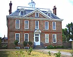 More images |
| Forecourt walls, piers, railings and gates of Eagle House | Mitcham | Gate | 1705 | 16 January 1954 | TQ2778669244 51°24′28″N 0°09′51″W / 51.407832°N 0.164118°W / 51.407832; -0.164118 (Forecourt walls, piers, railings and gates of Eagle House) | 1193413 |  More images |
Grade II*
| Name | Location | Type | Completed [note 1] | Date designated | Grid ref.[note 2] Geo-coordinates | Entry number [note 3] | Image |
|---|---|---|---|---|---|---|---|
| 22 Parkside | Wimbledon | Studio House | 1968–1970 | 22 February 2013 | TQ2370571239 51°25′36″N 0°13′19″W / 51.426666°N 0.222067°W / 51.426666; -0.222067 (22 Parkside) | 1409979 |  More images |
| Church of St Mary | Merton Park | Church | Early 13th century | 7 May 1954 | TQ2511269434 51°24′36″N 0°12′09″W / 51.410135°N 0.202476°W / 51.410135; -0.202476 (Church of St Mary) | 1080946 |  More images |
| Church of the Sacred Heart | Wimbledon | Roman Catholic Church | 1887–1901 | 28 May 1987 | TQ2391670250 51°25′04″N 0°13′10″W / 51.417731°N 0.219379°W / 51.417731; -0.219379 (Church of the Sacred Heart) | 1080957 |  More images |
| Eagle House | Wimbledon | House | 1613 | 1 June 1949 | TQ2387971169 51°25′34″N 0°13′11″W / 51.425999°N 0.21959°W / 51.425999; -0.21959 (Eagle House) | 1193286 | 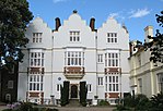 More images |
| Morden Park, including Walls and Pair of Circular Garden Buildings Attached to North West | Morden | House | 1770 | 2 September 1988 | TQ2484567557 51°23′36″N 0°12′25″W / 51.393325°N 0.206973°W / 51.393325; -0.206973 (Morden Park, including Walls and Pair of Circular Garden Buildings Attached to North West) | 1080902 | 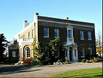 More images |
| Parish Church of St Mary | Merton Park | Parish Church | Late Medieval | 1 June 1949 | TQ2450271458 51°25′42″N 0°12′38″W / 51.428459°N 0.210532°W / 51.428459; -0.210532 (Parish Church of St Mary) | 1080917 | 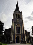 More images |
| Parish Church of St Peter and St Paul | Mitcham | Church | 1819–22 | 16 January 1954 | TQ2704768689 51°24′11″N 0°10′30″W / 51.40301°N 0.174936°W / 51.40301; -0.174936 (Parish Church of St Peter and St Paul) | 1080948 |  More images |
| Southside House | Merton Park | House | Earlier | 7 May 1954 | TQ2338370594 51°25′15″N 0°13′37″W / 51.420939°N 0.22692°W / 51.420939; -0.22692 (Southside House) | 1194026 |  More images |
| The Canons | Mitcham | House | Later alteration | 7 May 1954 | TQ2786568345 51°23′59″N 0°09′48″W / 51.399735°N 0.163306°W / 51.399735; -0.163306 (The Canons) | 1358036 |  Upload Photo |
| The Old Rectory House | Merton Park | House | c. 1500 | 1 June 1949 | TQ2447271534 51°25′45″N 0°12′39″W / 51.429149°N 0.210937°W / 51.429149; -0.210937 (The Old Rectory House) | 1080951 | Upload Photo |
| The Old Windmill | Wimbledon | House | 1860s | 1 June 1949 | TQ2301172444 51°26′16″N 0°13′54″W / 51.437646°N 0.231626°W / 51.437646; -0.231626 (The Old Windmill) | 1358050 |  More images |
Notes
- ^ a b The date given is the date used by Historic England as significant for the initial building or that of an important part in the structure's description.
- ^ a b Sometimes known as OSGB36, the grid reference is based on the British national grid reference system used by the Ordnance Survey.
- ^ a b The "List Entry Number" is a unique number assigned to each listed building and scheduled monument by Historic England.
External links
 Media related to Grade I listed buildings in the London Borough of Merton at Wikimedia Commons
- Media related to Grade II* listed buildings in the London Borough of Merton at Wikimedia Commons
- v
- t
- e
| Partly in other boroughs |
|---|


open spaces
- Bennett's Hole
- Cannizaro Park
- Cannon Hill Common
- Cherry Wood
- Cranmer Green
- Derwent Floodwash
- Figges Marsh
- Fishpond Wood and Beverley Meads
- Merton Park Green Walks
- Mitcham Common
- Mitcham Cricket Green
- Morden Hall Park
- Morden Park
- Myrna Close
- Ravensbury Park
- Sir Joseph Hood Memorial Wood
- Wandle Meadow Nature Park
- Wandle Park
- Wimbledon Common
- Wimbledon Park
- Mitcham and Morden
- Wimbledon
stations, and
tram stops


- Council
- Grade I and II* listed buildings
- Parks and open spaces
- People
- Public art
- Schools
 Category
- Commons

Portals:
 London
 Architecture


