Dodoni
Municipality in Greece
Dodoni Δωδώνη | |
|---|---|
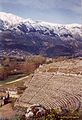
 View of Dodoni and mount Tomaros | |
| 39°33′N 20°46′E / 39.550°N 20.767°E / 39.550; 20.767 | |
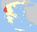
| Country | Greece |
| Administrative region | Epirus |
| Regional unit | Ioannina |
| Area | |
| • Municipality | 657.5 km2 (253.9 sq mi) |
| • Municipal unit | 101.0 km2 (39.0 sq mi) |
| • Community | 8.748 km2 (3.378 sq mi) |
| Population (2021)[1] | |
| • Municipality | 7,199 |
| • Density | 11/km2 (28/sq mi) |
| • Municipal unit | 937 |
| • Municipal unit density | 9.3/km2 (24/sq mi) |
| • Community | 185 |
| • Community density | 21/km2 (55/sq mi) |
| Time zone | UTC+2 (EET) |
| • Summer (DST) | UTC+3 (EEST) |
| Vehicle registration | ΙΝ |
Dodoni (Greek: Δωδώνη) is a village and a municipality in the Ioannina regional unit, Epirus, Greece. The seat of the municipality is the village Agia Kyriaki (community Theriakisi).[2]
The modern village of Dodoni is located near the ancient city of same name and site of the ancient oracle of Dodona. Oedipus the King was shot here in 1967.
Municipality
The present municipality Dodoni was formed at the 2011 local government reform by the merger of the following 4 former municipalities, that became municipal units:[2]
- Agios Dimitrios
- Dodoni
- Lakka Souliou
- Selloi
The municipality Dodoni has an area of 657.499 km2, the municipal unit Dodoni has an area of 101.016 km2, and the community Dodoni has an area of 8.748 km2.[3]
Gallery
-
 Theatre at Dodoni
 -
 View on theatre and Mount Tomaros


References
- ^ "Αποτελέσματα Απογραφής Πληθυσμού - Κατοικιών 2021, Μόνιμος Πληθυσμός κατά οικισμό" [Results of the 2021 Population - Housing Census, Permanent population by settlement] (in Greek). Hellenic Statistical Authority. 29 March 2024.
- ^ a b "ΦΕΚ A 87/2010, Kallikratis reform law text" (in Greek). Government Gazette.
- ^ "Population & housing census 2001 (incl. area and average elevation)" (PDF) (in Greek). National Statistical Service of Greece. Archived from the original (PDF) on 2015-09-21.
- v
- t
- e
Administrative division of the Epirus Region
- Arta
- Central Tzoumerka
- Georgios Karaiskakis
- Nikolaos Skoufas
- Regional governor
- Alexandros Kachrimanis [el] (since 2014)
- Decentralized Administration
- Epirus and Western Macedonia
 | This Epirus location article is a stub. You can help Wikipedia by expanding it. |
- v
- t
- e


