Dizbad-e Olya
You can help expand this article with text translated from the corresponding article in Persian. (June 2022) Click [show] for important translation instructions.
- Machine translation, like DeepL or Google Translate, is a useful starting point for translations, but translators must revise errors as necessary and confirm that the translation is accurate, rather than simply copy-pasting machine-translated text into the English Wikipedia.
- Do not translate text that appears unreliable or low-quality. If possible, verify the text with references provided in the foreign-language article.
- You must provide copyright attribution in the edit summary accompanying your translation by providing an interlanguage link to the source of your translation. A model attribution edit summary is
Content in this edit is translated from the existing Persian Wikipedia article at [[:fa:دیزباد]]; see its history for attribution. - You may also add the template
{{Translated|fa|دیزباد}}to the talk page. - For more guidance, see Wikipedia:Translation.
Village in Razavi Khorasan, Iran
Dizbad-e Olya دیزباد علیا | |
|---|---|
Village | |
 | |
| 36°06′07″N 59°16′55″E / 36.10194°N 59.28194°E / 36.10194; 59.28194 | |
| Country |  Iran Iran |
| Province | Razavi Khorasan |
| County | Nishapur |
| Bakhsh | Zeberkhan |
| Rural District | Zeberkhan |
| Elevation | 2,020 m (6,630 ft) |
| Population (2016) | |
| • Total | 910 |
| Time zone | UTC+3:30 (IRST) |
| • Summer (DST) | UTC+4:30 (IRDT) |
| Area code | 552 |
| Website | www.adelweb.ir |
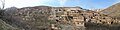
Dizbad-e Olya (Persian: دیزباد علیا, also known as Dīzbād-e Bālā or Dizbad)[1] is a village in Zeberkhan Rural District, Zeberkhan District, Nishapur County, Razavi Khorasan Province, Iran.
Geography
Dizbad-e Olya is located at an altitude of 2020 metres in the southern area of the Binalud Mountains 97 kilometres southwest of the city of Mashhad and 71 kilometres northwest of Neyshabur. The highest point in the area is Mount Qajqor at 2881 m above sea level. The area of Dizbad-e Olya also borders the two neighbouring villages of Qasemabad and Hesar.
Demographics
Economy
History
The historical background of Dizbad dates back to the year 714 AD. The name has changed many times throughout history. The oldest known name of Dizbad is Aspiduz (Persian: اسپیدوز), which includes the Persian words for horse and fort. In the ninth century it was known as Qasr al-Rih (Arabic: قصر الریح) due to the Arab invasion. The origin of this name is due to the three forts that once served as a defense system, they signalled by smoke signals when enemies tried to invade. Only ruins of these forts remain. In later times, Dizbad was known as Chehel Ashkub (Persian: چهل اشکوب).
Due to its long history and cultural background, the identity of the people in this area has undergone many changes. One of the most impactful events that caused this cultural change was the opening of the Naser Khosrow School in 1939. The establishment of this school encouraged families to send their children to school, which had a positive effect and resulted in a growing number of children from the village graduating from school.
Climate
Gallery
-

-
 Jama'at Khana Dizbad
 -

-


References
- ^ Dīzbād-e Bālā can be found at GEOnet Names Server, at this link, by opening the Advanced Search box, entering "-3061289" in the "Unique Feature Id" form, and clicking on "Search Database".
- v
- t
- e
Wikimedia Commons has media related to Dizbad-e Olya.
 Iran portal

 | This Nishapur County location article is a stub. You can help Wikipedia by expanding it. |
- v
- t
- e


