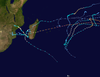
Very Intense Tropical Cyclone Freddy, also known as Severe Tropical Cyclone Freddy, was an exceptionally long-lived, powerful, and deadly tropical cyclone that traversed the southern Indian Ocean for more than five weeks in February and March 2023. Freddy was the longest-lasting tropical cyclone ever recorded worldwide, traveling across the southern Indian Ocean, Mozambique, and Madagascar for 36 days, surpassing the record set by Hurricane John in 1994.[nb 1] Freddy also produced the most Accumulated cyclone energy (ACE) of any individual cyclone. Additionally, it is the third-deadliest tropical cyclone recorded in the Southern Hemisphere, only behind 2019's Cyclone Idai and the 1973 Flores cyclone. Freddy was the fourth named storm of the 2022–23 Australian region cyclone season, and the second very intense tropical cyclone of the 2022–23 South-West Indian Ocean cyclone season.
Freddy first developed as a disturbance on 5 February 2023. While in the Australian region cyclone basin, the storm quickly intensified and became a Category 4 severe tropical cyclone, before it moved into the South-West Indian Ocean basin, where it intensified further. The Joint Typhoon Warning Center (JTWC) estimated 1-minute sustained winds of 270 km/h (165 mph) at Freddy's peak strength, equivalent to Category 5 strength on the Saffir–Simpson scale. On 19 February, Météo-France (MFR) upgraded it to a very intense tropical cyclone, estimated 10-minute winds of 220 km/h (140 mph). Freddy made its first landfall near Mananjary, Madagascar. The storm rapidly weakened overland but re-strengthened in the Mozambique Channel. Shortly afterward, Freddy made second landfall just south of Vilankulos, Mozambique, before rapidly weakening again. Unexpectedly, the system managed to survive its visit in Mozambique and emerged back over the channel on 1 March. Soon after, Freddy was re-classified as a tropical cyclone by the MFR. Over the course of 10 days, Freddy rapidly intensified on two occasions, eventually slowing to a semi-stationary movement near Quelimane, Mozambique. Moving northwest inland, the storm gradually deteriorated and was last noted on 14 March.
Preparations for the storm in the Mascarene Islands included flight groundings, cyclone alerts, and personnel being prepped for the aftermath, among other things. In Madagascar, areas previously affected by Cyclones Batsirai and Cheneso were feared to be worsened by the storm's arrival. Impacts in Mozambique were more severe than in Madagascar and included heavy rainfall in the southern half of the country and widely damaged infrastructure. Effects in Mozambique were exacerbated after its second landfall with further floods and wind damage. The hardest-hit was Malawi where incessant rains caused catastrophic flash floods, especially Blantyre. The nation's power grid was crippled, with its hydroelectric dam rendered inoperable.
Overall, the cyclone killed at least 1,434 people, injured 2,004 others, and inflicted an estimated US$481 million in damage. Due to the damage and loss of life, the name Freddy was later retired from the Australian rotating naming lists by the Bureau of Meteorology.
Cyclone Freddy originated from a Madden-Julian Oscillation (MJO) and an equatorial Rossby wave in the Australian region, which contributed to the formation of a tropical low on 5 February. A circulation was ill-defined, but by the evening and overnight, persistent atmospheric convection had occurred and was beginning to show signs of better organization; the Australian Bureau of Meteorology (BoM) reported that the tropical low had developed into a Category 1 tropical cyclone on the Australian scale and assigned the name Freddy.[1][2] On the same day, the Joint Typhoon Warning Center (JTWC) classified the system as Tropical Cyclone 11S.[3] The BoM subsequently upgraded Freddy into a Category 2 tropical cyclone, before further upgrading it to a Category 3 severe tropical cyclone.[2] The cyclone began showing an eye feature visible in microwave imaging.[4] Freddy weakened slightly due to its central dense overcast and a persistent area of cold cloud tops. The JTWC assessed that Freddy's winds bottomed out at 150 km/h (90 mph).[5][6] Freddy weakened back into a tropical storm, and the BoM estimated winds of 100 km/h (65 mph), the weakening resulting from easterly wind shear.[7][8] Freddy had further intensified into a Category 4 severe tropical cyclone due to the presence of a well-defined eye surrounded by deep convection.[2] Freddy gradually became disorganized, with its eye no longer well-defined.[9]
During 14 February, Freddy crossed 90° E into the South-West Indian Ocean basin and was immediately classified as a tropical cyclone by Météo-France (MFR).[10][11] The JTWC assessed Freddy as having 1-minute maximum sustained winds of 270 km/h (165 mph), making the storm a Category 5-equivalent tropical cyclone on the Saffir–Simpson hurricane wind scale (SSHWS).[12][13] Later the next day, Freddy was upgraded to a very intense tropical cyclone by the MFR.[14] Freddy's cloud pattern slightly deteriorated, causing the cyclone to weaken to an intense tropical cyclone.[15] and weakened to a tropical cyclone on 21 February.[16] At about 7 p.m. local time on the same day, the cyclone made its first landfall near Mananjary, Madagascar.[17] During the next day Freddy significantly improved in organization as it moved southwestward across the Mozambique Channel.[18] Freddy re-strengthened into a moderate tropical storm after the convection began to rapidly increase.[19] By 12:00 UTC on 24 February, the MFR reported that Freddy had made a second landfall south of Vilankulos, Mozambique, with 10-minute sustained winds of 85 km/h (50 mph).[20] Freddy rapidly weakened as it moved westward and further inland, weakening to an overland depression by 18:00 UTC that day.[21] Freddy re-emerged over the Mozambique Channel on 2 March, the MFR resumed advisories on the system as a tropical disturbance.[22] Throughout the next day, Freddy was downgraded to zone of disturbed weather status.[23] Satellite imagery showed that an ill-defined eye was visible, and Freddy intensified further into a tropical cyclone.[24][25] Freddy rapidly weakened as a result of the presence of higher wind shear as well as dry air intrusion.[26] Later that next day, the storm's winds weakened to 110 km/h (70 mph).[26] However, the JTWC and MFR later indicated that the winds strengthened to 120 km/h (75 mph).[27][28] Freddy made its final landfall on Quelimane, Zambezia Province, Mozambique, with sustained winds of 150 km/h (90 mph) on 11 March.[29][30] The system gradually degraded and MFR ceased monitoring it as a tropical cyclone on 14 March.[31]
Preparations
Mauritius
Cyclone Freddy approaching Mauritius on 19 February.
A class I cyclone warning was issued by Mauritius for Rodrigues, and later a class II cyclone warning was issued.[32][33] Flights from Rodrigues to Saint-Denis, Réunion, were canceled or rescheduled due to inclement weather.[34] Prime Minister Pravind Jugnauth stated this during a radio and television address urging vigilance and caution.[35] The Mauritius Meteorological Services (MMS) issued a class III cyclone warning, estimating that Freddy's center gusts might reach up to 300 km/h (185 mph).[36] The country also shut down its stock exchange as the storm neared.[37] A total of 1,019 people sought refuge in public shelters.[38]
Réunion
On 18 February, a cyclone yellow pre-alert was issued for the island of Réunion by the MFR.[39] The following day, this was upgraded to an orange alert which prompted all schools to close. Hospital patients whose conditions did not require immediate treatment were to return home while those with more care-intensive needs were to be transported to designated facilities.[40] The island's power company, EDF La Réunion, prepped 200 personnel with a further 100 people from subcontracted companies for immediate repairs once storm conditions subsided. Call centers were staffed with 60 additional workers. The company also prepped 50 vehicles, electrical equipment, 15 generators, and 4 helicopters for use.[41] Residents in areas hard-hit by Cyclone Batsirai in February 2022 worried of exacerbated damage upon Freddy's arrival.[42] Authorities in Le Tampon were mobilizing for the system's arrival.[43]
High seas prompted the closure of the Nouvelle route du Littoral with bus shuttles established to transport residents through inland routes to and from communities in the north and west.[44][45] On 20 February, the RSMA-R mobilized 250 personnel for relief efforts.[46] All service at Roland Garros Airport was suspended the same day, with service to resume following the cyclone's passage.[47] A red alert for coastal flooding was issued for areas between Champs Borne and Pointe des Cascades.[48] The city of Saint-Benoît opened two public shelters and closed all sporting facilities.[49] Officials in Saint-Pierre postponed a local carnival for more than two weeks.[50]
Madagascar
Cyclone Freddy passing by Mauritius on 20 February
Cyclone Freddy threatened areas of Madagascar still reeling from the successive impacts of Cyclones Batsirai and Emnati in 2022; 874,000 people remained food insecure in the region.[51]Medair noted that the region was suffering from a surge in childhood malnutrition stemming from an inadequate humanitarian response to the aforementioned cyclones.[52] On 18 February, General Directorate of Meteorology issued warnings for the Analanjirofo and Sava regions, advising residents to take precautions as the cyclone was expected to make landfall.[53] In the landfall area, Madagascar's weather service noted "torrential rains" and "very high to enormous seas" were of concern.[37] The government of Madagascar pre-positioned 120 tonnes (120 long tons; 130 short tons) of rice to areas threatened by Freddy.[51] Transportation services and schools were closed on 21 February.[54] Residents at risk of Freddy placed sandbags over their homes' roofs for reinforcement.[55]
The International Federation of Red Cross and Red Crescent Societies (IFRC) in Madagascar announced it was preparing for the cyclone.[53]Météo-France noted on 19 February that accumulations for 200 mm (7.9 in) were possible for the southern regions of Madagascar.[56] The Global Disaster Alert and Coordination System estimated over 2.2 million people would be affected by Freddy's storm surge and flooding in the country.[57] Tents, ropes, chainsaws, and other supplies have been sent by the National Office for Risk and Disaster Management (BNGRC) to the eastern districts.[58] The United Nations Office for the Coordination of Humanitarian Affairs (OCHA) and its partners deployed 80 humanitarian staff to Mahanoro, Mananjary, and Manakara, and placed two aircraft on standby. The agency was unable to sufficiently allocate emergency supplies due to a lack of funding and shortages from Cyclone Cheneso the month prior.[51] Medair already had field offices in place after Cyclone Cheneso in southern and southeastern Madagascar. Emphasis was placed on providing clean drinking water and emergency kits to residents in Marondava and Maroansetra.[52] At least 7,000 people were pre-emptively evacuated from at-risk coastal regions before Freddy's arrival.[59]
Mozambique
In February 2023, local reports had estimated over 600,000 people were expected to be affected in the country by the cyclone alone.[60] Rainfall predictions reached 200–300 mm (7.9–11.8 in) south of Beira into Inhambane Province, with 400 mm (16 in) locally. Overall, a month's worth of rain was forecasted.[61] The country's national meteorological service issued a red alert on 21 February. Freddy's intense and prolonged rainfall was also feared to worsen flooding in central and northern areas, affecting up to 1.75 million people, this rainfall also caused deadly landslides.[62] Rescue teams, food supplies, tents, and boats were put in place to support the aftermath.[63]
During March 2023, as Freddy approached a second time, the Mozambique National Meteorology Institute (INAM) predicted torrential rains of more than 200 mm (7.9 in) in 24 hours in the provinces of Manica, Sofala, Tete, and Zambezia. Peak rainfall was forecasted to be between 400–500 mm (16–20 in).[64] According to the National Institute for Disaster Risk Management and Reduction (INGD), approximately 565,000 people were at risk,[65] though a United Nations and European Union-led disaster alert predicted 2.3 million were at risk. Thousands were moved to evacuation shelters as precaution.[66]
Malawi
Cyclone Freddy was expected to hit Malawi, and bring with it torrential rains and damaging winds to the southern region.[67] Forecasts predicted accumulations of rainfall there could reach 400–500 mm (16–20 in).[67] The Ministry of Education ordered the suspension of all classes in districts at risk.[67]
In general, Freddy produced extraordinarily heavy rains, primarily in Mozambique and Malawi. Heavy winds lashed areas as well, and infrastructure took heavy hits due to excessive flooding. Freddy's stalling over Mozambique and Malawi worsened the rains immensely.
Mauritius
According to the MMS, the cyclone passed within 200 km (120 mi) of the island, just north of Grand Bay.[84] Strong winds and waves were observed along the northern coast of Mauritius.[37] Winds in Port Louis reached 104 km/h (65 mph) while a peak gust of 154 km/h (96 mph) was observed on Signal Mountain.[85] Flooding and gale-force winds also affected the country.[86] According to media reports, there was one fatality, and at least 500 displaced families in a variety of shelters across Mauritius.[75]
Around 4:00 a.m. local time on 20 February, contact was lost with the Taiwanese-flagged fishing trawler LV Lien Sheng Fa with a crew of 16 just outside the territorial waters of Mauritius.[87] The crew included a Taiwanese captain and 15 Indonesian fishermen. An alert was sent out by Taiwan's Fisheries Agency for the missing vessel on 23 February.[88] The MV Star Venture found the ship capsized on 25 February about 400 km (250 mi) northeast of Mauritius within the nation's exclusive economic zone. Later sorties by the aircraft Dornier and the ship CGA Baracuda failed to find any survivors.[77][88] Mauritius deployed a diving team to confirm the identity of the ship.[88] The vessel's lifeboat was confirmed to have been deployed; however, it has not been found as of 3 March.[88]
Réunion
Freddy impacted Réunion on 20–21 February, with its effects being relatively limited.[89] Nearly 25,000 customers were left without power at the height of the cyclone; all but 500 had their service restored within a day.[90] In Saint-Paul, 20 tons of mangoes were destroyed.[91] Highway RD48 in Salazie was closed due to a landslide.[92] Eleven mobile sites maintained by Orange S.A. were knocked offline in Tampon, Saint-Louis, and Saint-Paul.[89] On 23 February, Foehn winds on the backside of the storm led to temperatures reaching 31 to 36 °C (88 to 97 °F) along the southwestern coast of Réunion.[93]
Madagascar
Cyclone Freddy approaching Madagascar on 21 February
Damage was less than expected due to Freddy's weaker-than-forecasted winds, and early preparations.[94][62] Freddy made its first landfall near Mananjary, which was still recovering from Cyclone Batsirai a year earlier.[95][96] In total, over 14,000 homes were affected, with 1,206 destroyed, 3,079 flooded, and at least 9,696 damaged.[59] At least 22,500 people were displaced, with over 12,000 in Mananjary alone.[97][98] Freddy also left 79 schools roofless, and damaged or destroyed 37 and 6 respectively. The storm's effects caused more 11,000 to flee their homes.[99] The impact zone of Freddy included 13-15 municipalities.[94] About 16 km2 (6.2 sq mi) of land was flooded according to UNOSAT.[100] Overall, the cyclone was responsible for seven deaths, and affected 226,000.[101]
On its second arrival, Cyclone Freddy brought severe rains to the southwestern portion of the country.[102] At least 72,600 people were affected by the cyclone, including 20 people who were displaced, of whom 16,367 are in 34 temporary sites in several districts, and over 7,900 are living with relatives in the regions of Menabe and Atsimo Andrefana.[102] 158 of which were destroyed, 67 of which were damaged, and 55 of which had no roofs.[102] Overall, 12,400 houses (6,000 of which were flooded, 900 of which were damaged, and 5,500 of which were destroyed) and 280 classrooms, some 28,000 students were prevented from attending school.[102] Ten people have died and three were missing.[102]
Mozambique
During February 2023, Cyclone Freddy made its first landfall in Mozambique (and second landfall overall) south of Vilanculos, Inhambane Province, causing heavy rains, strong winds, and rough seas.[103][104] Some damage was reported, primarily due to fallen trees and rooftops.[105] Public infrastructure and services have also suffered widespread damage, including 60 health units, 1,012 schools.[106][29] At least ten people died in the country during the first landfall. Over 166,600 were affected.[107][108] Much of the southern half of the country saw rainfall totaling 200 to 500 mm (7.9 to 19.7 in).[109] Thousands of homes were damaged, with approximately 28,300 destroyed.[108] 1,265 km (786 mi) of road across many were damaged.[109] More than 92,000 hectares of crops were affected, and more than 18,700 hectares of crops were lost in areas where 400,000 were food insecure.[107][109] The storm struck during a cholera outbreak, raising worries of the storm worsening its effects.[29]
Cyclone Freddy off the coast of Mozambique on 11 March.
In March 2023, Freddy made its second landfall in Zambezia Province on 11 March, bringing torrential rainfall, storm surge, and much stronger winds compared to the prior landfall. The Zambezi and Tambarara river basins had reported above-average water levels before its landfall.[29] The power utility had turned off the electricity completely as a precaution against the cyclone.[110] Locals reported seeing roofs torn off houses, broken windows, and streets flooded in Quelimane.[111] Sustained winds of 175 km/h (110 mph), gusting up to 215 km/h (130 mph) were recorded in the city.[112] All flights were suspended due to the inclement weather brought by Freddy.[113]
Communications and electrical supplies were cut early into the storm, hampering damage assessments. Power company Electricidade de Moçambique said that most areas had electricity restored by 11 March mid-afternoon. The nation's UNICEF chief of advocacy, communications, and partnerships, Guy Taylor, stated that there was "lots of destruction", and that Freddy was "potentially a disaster of large magnitude".[114] Taylor also noted that rural areas were completely destroyed. Access to clean water was effectively cut off in Quelimane.[115]
Wettest tropical cyclones and their remnants in Mozambique Highest-known totals
State TV reported that hundreds were displaced in Freddy's wake. More than 650 houses in Marromeu District, and over 3,000 in Sofala province were affected by flooding.[121] The nation saw a year's worth of rainfall in just 4 weeks. Locals said localized flooding was an issue even before landfall.[122] In a preliminary satellite evaluation of 24,000 km2 (9,300 sq mi) of land, 900 km2 (350 sq mi) was estimated to be flooded.[123] Widespread areas received over 500–1,000 mm (20–39 in) of rainfall, with smaller, localized pockets of 1,000–1,500 mm (39–59 in),[124] eclipsing the maximum accumulations of Cyclone Idai 4 years earlier. 348,000 hectares of cropland were damaged, and over 800,000 people were living in flooded areas following Freddy. Cholera cases also increased among affected populations. A total of 8 provinces were damaged by the cyclone. 1,017 schools took a hit, and more than 5,000 km (3,100 mi) of road was damaged. This includes the main national road, N1, which was restored by 21 March. A total of 103,000 houses were destroyed, and another 25,000 had been flooded. Some 15,000 people were stranded when they moved to higher ground for protection.[125]
The old provincial hospital in Quelimane had its roof blown off, making supporting those in need more difficult. Many people were left homeless during the storm and took shelter in schools, the latter being turned into reception areas. Large amounts of crop fields were flooded as well.[126] The INGD stated that the storm's effects on Mozambique were worse than expected. Freddy affected areas were initially deemed safe beforehand.[115] Overall, Freddy caused at least 143 deaths on its second arrival. At least 886,487 people were affected as well. An estimated 49,000 were displaced and another 280 were injured.[127][128] At least 22 deaths from cholera were blamed on Freddy and the subsequent flooding.[79]
Malawi
Moderate Tropical Storm Freddy weakening after its landfall in Mozambique on 12 March.
Before Freddy arrived in Malawi, the country had been experiencing its worst cholera outbreak in history. Freddy's effects increased fears among the public that it would worsen.[129] Rainfall was heaviest in the southern region of the country.[130] These districts include Blantyre, Phalombe, Mulanje, Chikhwawa, and Nsanje.[131] Flash floods devastated many regions, washing away homes and people and leaving infrastructure ruined.[132] The entire nation experienced blackout due to the Electricity Generation Company Malawi Limited (EGENCO) shutting down power to avoid further damage to power-generating machines.[122] The nation's hydroelectric power plant, which provides a large portion of the country with electricity, was rendered inoperable by debris.[132]
At least 1,216 people were killed in the onslaught of Freddy with 1,332 injuries reported.[133][134][71] At least 192 of these deaths were reported in Blantyre, and at least 40 of whom were children according to Médecins Sans Frontières. 135 of them were in Mulanje as well.[135] 180,000 people were displaced across the country and forced to evacuate their homes,[136] with 500,000 affected in general. Among these 280,000 were children.[74][137] There were also around 90 fatalities in Mulanje.[136] More than 50,000 houses were damaged or destroyed.[138] In terms of rainfall, over a month's worth of rain was dumped in just a day,[139] totaling to six months of precipitation in six days.[138] The small village of Mtauchira in Chiradzulu District was completely destroyed by a landslide that fell from Chambe Peak.[140]
Over 430 km2 (170 sq mi) of general land was flooded, causing many smallholder farmers to have their crops and fields lost to the storm. Approximately 204,833 hectares of cropland were inundated - 84,930 being submerged and 119,930 were washed away. The storm struck just as farmers were about to harvest, compounding to local food insecurities in the nation. Farms were also damaged and many were destroyed. Livestock was severely impacted, with 194,500 dying and a further 91,000 being injured.[141][142] Notable rainfall recordings include a record-setting 458 mm (18.0 in) in 24 hours in Phalombe District. Several other districts also reported 300 mm (12 in) in the same time range.[139][143][138] Flood waters rose in some areas days after Freddy died, with an analyzed area of 5,000 km2 (1,900 sq mi) increasing by 60 km2 (23 sq mi) between 14 and 17 March. Houses whose foundations were weakened by the system also collapsed in Mangochi District.[137]
Dozens of houses were reported being washed away in floodwaters in Chilobwe. Schools in ten southern regions were ordered to be closed until 15 March.[115] Heavy rains also were reported in Salima and Lilongwe.[122] Malawian president Lazarus Chakwera declared a state of disaster in the southern regions.[115] Victims were thought to be buried under rubble and debris.[144] During Freddy's extended stay in the country, visibility remained at near-zero levels. Several roads and bridges were cut, and many areas were cut off.[145] Landslides across Chiradzulu Mountain blocked roadways, leaving Chiradzulu Boma inaccessible.[140] It was stated that 14[146] districts suffered impacts from Freddy, equating to over half the country. Chakwera also said that 36 roads were broken, nine bridges washed away, and there were still many villages inaccessible by 20 March.[147]
Elsewhere in mainland Africa
Heavy rainfall extending from Freddy impacted eastern Zimbabwe for a prolonged period as it meandered over Mozambique and the Mozambique Channel.[148] At the end of February as the storm moved over Mozambique, heavy rains and strong winds impacted the nation. Five homes and two schools had their roofs torn off in Mashonaland Central Province. One person was killed in Shamva on 26 February when the tree they were sheltering from the rain under collapsed.[149] A second person was killed by unspecified causes.[82] In Masvingo Province, one home was destroyed by rainfall and another was struck by lightning.[149]Manicaland Province in particular was heavily affected with continuous rainfall from 12 to 14 March. Observed rainfall totals include 102 mm (4.0 in) in Nyanga and 97 mm (3.8 in) in Mukandi.[148] Crops were adversely affected in the Chipinge and Chiredzi districts.[148][149] Rainfall of at least 251 mm (9.9 in) occurred across regions of South Africa and Eswatini.[124] Heavy rainfall also occurred in Zambia.[150]
Aftermath
Due to the storm striking during a historic cholera outbreak, water purification supplies were in critical need, and in short supply.[151] Following Freddy, many countries sent relief aid to southern Africa, with a particular emphasis on the humanitarian disaster in Malawi. Among the items were hygiene supplies, food rations, and safe drinking water.[152] Total donations reach the millions in USD, and there was a main focus on the region's historic and ongoing Cholera outbreak. Several nations also expressed condolences to Malawi, Mozambique, and Madagascar.[153]
Madagascar
64 tons of food relief rations were made available following Freddy's passing.[98] Several shelter sites were opened, with many being vacated within a day of the storm. The World Food Programme offered thousands of hot meals to those in shelters. Financial assistance was planned to be provided to 100,000 people for up to two months, and food assistance to 40,000 for three months.[94] OCHA has provided WFP with a $100 million Emergency Cash Grant, which will be utilized for immediate aerial inspections and logistics support following the cyclone.[154] WFP has sent a 6x6 truck carrying five metric tons of high-energy biscuits to Toliara as part of the emergency response.[155]
Mozambique
UNICEF provided water purification supplies, medical items, tents, and hygiene kits among other things to help families and children.[103] By 13 March, 5,000 were living in the accommodation and over 100,000 needed humanitarian assistance. The government was not prepared for a storm of Freddy's magnitude, and struggled to provide an effective response.[126]Amnesty International suggested that Mozambique be compensated for impacts by Freddy, due to being least responsible for climate change.[156] By 24 March, 230 accommodation centers remained operational, housing 184,282 people. The WFP also provided 7-day rations of food through cash-based transfers for 17,545 people.[80]
Mozambican president, Filipe Nyusi, appealed for aid and to rebuild infrastructure.[157] He also provided MT250 million ($3.9 million) to Zambezia province to help restore everyday activities.[158] The WFP requires $26.7 million to assist 541,000 people impacted by Cyclone Freddy.[159] As a result of flooding caused by the storm as well as the cutoff of access to water, sanitation, and hygiene services, cholera cases began to rapidly increase. At least 36 districts spanning 8 provinces are having outbreaks; the Inhambane and Zambezia provinces, which were heavily affected by Freddy, have declared outbreaks of cholera.[160] The cumulative figure for the cases by 21 March stood at 11,158 across the provinces, and other waterborne illnesses such as diarrhea and malaria were of risk. The INGD did not have food and supplies for immediate response, significantly slowing emergency aid.[128] As the nation tries to contain a rapidly spreading outbreak, Mozambique has requested an additional 2 million doses of a cholera vaccine from the World Health Organization.[161]
Malawi
By 18 March the Government of Malawi established 534 camps to house 508,244 displaced persons, equating to 101,648 households.[142] Humanitarian partners worked closely with the government despite the harsh conditions brought by Freddy. Relief items placed before the storm were used to support families.[162] Rescue teams were sent in Chilobwe, Machinjiri and Ndirande residential areas in Blantyre. Malawian citizens pooled resources to help displaced victims in Blantyre residential areas.[122]Amnesty International suggested that Malawi be compensated for impacts by Freddy, due to being least responsible for climate change as well.[156]
Operational Land Imager captured this satellite (top right), which depicts damaged farmland in southern Malawi on 10 April.
Government-led search-and-rescue operations consisting of the Red Cross, local military, and police also commenced following the storm. On 16 March alone, 442 people were rescued. Sniffer dogs were also used for such operations, as many people were trapped under rubble and mud. Several areas were still rendered inaccessible days after Freddy dissipated.[163][164] Millions of children were at risk of an increase in cholera cases as well. Due to cholera being transmitted through contaminated water and food, Freddy's flooding rose worries of the disease spreading greatly.[165] Chakwera also invited the country's former presidents to a caucus to discuss methods and strategies to respond to the cyclone.[166] It took up to a week or more for families in cut off areas to receive aid, mostly by helicopters provided by Tanzania, Zambia, and Malawi's defense force.[71]
"The destruction and suffering that I witnessed in southern Malawi is the human face of the global climate crisis."
— Rebecca Adda-Dontoh, the United Nations Resident Coordinator for Malawi[167]
Food prices jumped by over 300%, quadrupling to record heights in an already food-insecure nation. Maize prices also shot up 400% in places like Nsanje.[168] The Everlasting Life Missionary Church donated assorted clothes to survivors in Zomba. They also fed children at camps, some of whom had not eaten at all since Freddy. They also sent out basic supplies such as body lotion, soap, and others.[169] The crisis that ensued after Freddy also presented several negative mental health consequences among locals and frontline aid workers. Various protection services were interrupted (including childcare centers), and gender-based violence was highlighted as a prominent issue. Those affected also trafficked women, adolescent girls, and other children. Families were separated, leaving youth unattended and alone.[170] EGENCO resumed operations at the Nkula and Tedzani power stations on 14 March as water along the Shire River returned to safer levels.[171] Lazarus Chakwera declared a national two weeks of mourning for the victims of Freddy. The government promised $1.5 million for aid to those affected. The president surveyed the damage, calling it "far worse than the images and footage we've seen".[157] Malawi's president Lazarus Chakwera has appealed for foreign assistance, claiming that the country requires $700 million for reconstruction.[172]
The OCHA brought vital emergency supplies to the hardest-hit regions. These included medical items, hygiene kits, and even support boats from the World Food Programme for those trapped in floodwaters and rubble. By 16 March, Nsanje had set up 24 camps to accommodate 4,502 households, with Chikwawa having 21 camps for 8,837 homes.[139] Malawian Former President Peter Mutharika has criticized the Chakwera administration of failing to evacuate people in the path of Cyclone Freddy before the disaster struck.[173]
Records and retirement
Cyclone Freddy lasted 36 days[nb 1], made it the longest-lasting tropical cyclone worldwide, beating the previous record set by Hurricane John in 1994.[83] Additionally, Freddy was also the second-farthest traveling tropical cyclone in globally and the furthest in the Indian Ocean, with a distance traveled of 12,785 km (7,945 mi), or about 33% of the Earth's circumference.[83] In addition, Freddy also holds the record for the all-time highest accumulated cyclone energy of a tropical cyclone worldwide, with an ACE of 87.01, breaking the previous record, set by Hurricane Ioke in 2006, of 85.26.[174][175] Freddy was the first tropical cyclone to undergo seven separate rounds of rapid intensification.[175][175] and was one of only four systems to traverse the entirety of the southern Indian Ocean from east to west; the others were cyclones Litanne in 1994 as well as Leon–Eline and Hudah in 2000.[176]
As a result of the major loss of life and damage in Malawi and surrounding countries, the name Freddy was removed from the rotating lists of Australian region cyclone names and will never be used to name a storm in that basin again. A replacement name is yet to be announced.[177]
Cyclone Idai (2019) – a devastating tropical cyclone which also had an erratic track within the Mozambique Channel similar to Freddy.
Cyclone Batsirai (2022) – a powerful tropical cyclone that caused catastrophic damage in Madagascar.
Cyclone Darian (2022) – another strong and long-lasting tropical cyclone that reached VITC status in the same season.
Cyclone Cheneso (2023) – a strong tropical cyclone that affected Madagascar a month prior.
Notes
^ abOnly count the number of days maintaining tropical storm status or higher
^The missing persons for Mauritius were from a capsized Taiwanese-flagged fishing trawler that was found within the nation's exclusive economic zone.[77]
References
^Eastern Region Tropical Cyclone Technical Bulletin issued at 0740 UTC 05/12/2023 (Report). Australian Bureau of Meteorology. 5 December 2023. Archived from the original on 5 December 2023. Retrieved 5 December 2023.
^ abcClegg, Pete; Craig, Earl-Spurr; Paterson, Linda (17 June 2022). Severe Tropical Cyclone Freddy (PDF) (Report). Tropical Cyclone Report. Perth, Western Australia: Bureau of Meteorology. Archived (PDF) from the original on 26 July 2023. Retrieved 19 July 2023.
^Tropical Cyclone 11S (Eleven) Warning No. 1 (Report). United States Joint Typhoon Warning Center. 6 February 2023. Archived from the original on 7 January 2023. Retrieved 6 February 2023. Alt URL Archived 6 February 2023 at the Wayback Machine
^Prognostic Reasoning for Tropical Cyclone 11S (Freddy) Warning No. 6 (Report). United States Joint Typhoon Warning Center. 7 February 2023. Archived from the original on 7 February 2023. Retrieved 7 February 2023. Alt URL Archived 8 February 2023 at the Wayback Machine
^Prognostic Reasoning for Tropical Cyclone 11S (Freddy) Warning No. 10 (Report). United States Joint Typhoon Warning Center. 8 February 2023. Archived from the original on 9 February 2023. Retrieved 8 February 2023.
^Prognostic Reasoning for Tropical Cyclone 11S (Freddy) Warning No. 8 (Report). United States Joint Typhoon Warning Center. 8 February 2023. Archived from the original on 8 February 2023. Retrieved 8 February 2023.
^"Tropical Cyclone Technical Bulletin (Western Region)". Australian Bureau of Meteorology. 9 February 2023. Archived from the original on 9 February 2023. Retrieved 9 February 2023.
^Prognostic Reasoning for Tropical Cyclone 11S (Freddy) Warning No. 13 (Report). United States Joint Typhoon Warning Center. 9 February 2023. Archived from the original on 9 February 2023. Retrieved 9 February 2023.
^Prognostic Reasoning for Tropical Cyclone 11S (Freddy) Warning No. 20 (Report). United States Joint Typhoon Warning Center. 12 February 2023. Archived from the original on 12 February 2023. Retrieved 12 February 2023.
^Tropical Cyclone 07 (Freddy) Warning Number (1/7/20222023) (PDF) (Report). Météo-France. 14 February 2023. Archived from the original (PDF) on 15 February 2023. Retrieved 14 February 2023.
^"Tropical Cyclone Forecast Track Map for Severe Tropical Cyclone Freddy (13U)". Australian Bureau of Meteorology. 14 February 2023. Archived from the original on 14 February 2023. Retrieved 14 February 2023.
^Cappucci, Matthew. "Cyclone Freddy teeters on brink of Category 5 strength in Indian Ocean". The Washington Post. ISSN 0190-8286. Archived from the original on 17 February 2023. Retrieved 17 February 2023.
^Very Intense Tropical Cyclone 07 (Freddy) Warning Number (19/7/20222023) (PDF) (Report). Météo-France. 19 February 2023. Archived from the original (PDF) on 19 February 2023. Retrieved 19 February 2023.
^Intense Tropical Cyclone 07 (Freddy) Warning Number (23/7/20222023) (PDF) (Report). Météo-France. 20 February 2023. Archived (PDF) from the original on 21 February 2023. Retrieved 20 February 2023.
^Tropical Cyclone 07 (Freddy) Warning Number (28/7/20222023) (PDF) (Report). Météo-France. 21 February 2023. Archived (PDF) from the original on 21 February 2023. Retrieved 21 February 2023.
^"Cyclone Freddy Moving Across Madagascar, Then A Flood Danger For Mozambique". www.wunderground.com. Archived from the original on 22 February 2023. Retrieved 22 February 2023.
^Zone of Disturbed Weather 07 (Freddy) Warning Number (33/7/20222023) (PDF) (Report). Météo-France. 22 February 2023. Archived (PDF) from the original on 23 February 2023. Retrieved 23 February 2023.
^Moderate Tropical Storm 07 (Freddy) Warning Number (36/7/20222023) (PDF) (Report). Météo-France. 23 February 2023. Archived (PDF) from the original on 23 February 2023. Retrieved 23 February 2023.
^Moderate Tropical Storm 07 (Freddy) Warning Number (41/7/20222023) (PDF) (Report). Météo-France. 24 February 2023. Archived (PDF) from the original on 24 February 2023. Retrieved 24 February 2023.
^Overland Depression 07 (Freddy) Warning Number (42/7/20222023) (PDF) (Report). Météo-France. 24 February 2023. Archived (PDF) from the original on 24 February 2023. Retrieved 24 February 2023.
^Tropical Disturbance 07 (Freddy) Warning Number (46/7/20222023) (PDF) (Report). Météo-France. 2 March 2023. Archived (PDF) from the original on 2 March 2023. Retrieved 2 March 2023.
^Zone of Disturbed Weather 07 (Freddy) Warning Number (47/7/20222023) (PDF) (Report). Météo-France. 3 March 2023. Archived (PDF) from the original on 3 March 2023. Retrieved 3 March 2023.
^Severe Tropical Storm 07 (Freddy) Warning Number (63/7/20222023) (PDF) (Report). Météo-France. 7 March 2023. Archived (PDF) from the original on 7 March 2023. Retrieved 7 March 2023.
^Tropical Cyclone 07 (Freddy) Warning Number (64/7/20222023) (PDF) (Report). Météo-France. 7 March 2023. Archived (PDF) from the original on 7 March 2023. Retrieved 7 March 2023.
^ abPrognostic Reasoning for Tropical Cyclone 11S (Freddy) Warning No. 54 (Report). United States Joint Typhoon Warning Center. 9 March 2023. Archived from the original on 9 March 2023. Retrieved 9 March 2023.
^Tropical Cyclone 07 (Freddy) Warning Number (73/7/20222023) (PDF) (Report). Météo-France. 9 March 2023. Archived (PDF) from the original on 9 March 2023. Retrieved 9 March 2023.
^Prognostic Reasoning for Tropical Cyclone 11S (Freddy) Warning No. 56 (Report). United States Joint Typhoon Warning Center. 10 March 2023. Archived from the original on 10 March 2023. Retrieved 10 March 2023.
^ abcd"Mozambique: Severe Tropical Storm Freddy – Flash Update No.8 (as of 11 March 2023) – Mozambique". reliefweb.int. 11 March 2023. Archived from the original on 12 March 2023. Retrieved 11 March 2023.
^Tropical Cyclone 07 (Freddy) Warning Number (81/7/20222023) (PDF) (Report). Météo-France. 11 March 2023. Archived (PDF) from the original on 12 March 2023. Retrieved 11 March 2023.
^"Best Track Data on Very Intense Tropical Cyclone Freddy (07)". Météo-France. Archived from the original on 13 March 2023. Retrieved 15 March 2023.
^"Cyclone Warning Bulletin Rodrigues (French Version)". Mauritius Meteorological Services. 18 February 2023. Archived from the original on 18 February 2023. Retrieved 18 February 2023.
^"Weather | Rodrigues: a Class II cyclone warning is in effect – Mauritius News". Archived from the original on 19 February 2023. Retrieved 18 February 2023.
^"Air Mauritius | Cyclone Freddy: flight cancellations and rescheduling". Archived from the original on 19 February 2023. Retrieved 18 February 2023.
^"Cyclone Freddy : le PM mauricien appelle à la vigilance et à la prudence – Xinhua – french.news.cn". french.xinhuanet.com. Archived from the original on 20 February 2023. Retrieved 20 February 2023.
^"WATCH: Mauritius braces for intense Cyclone Freddy". Jacaranda FM. Archived from the original on 20 February 2023. Retrieved 20 February 2023.
^ abc"As cyclone nears, Mauritius and Madagascar brace for floods, storm surge". MSN. Archived from the original on 21 February 2023. Retrieved 20 February 2023.
^"Cyclone Freddy : 1019 personnes dans les centres d'évacuation". Defimedia.info (in French). 20 February 2023. Archived from the original on 21 February 2023. Retrieved 21 February 2023.
^"Saison cyclonique : La Réunion entre en pré-alerte jaune cyclonique à partir de 19h". Linfo.re. Archived from the original on 18 February 2023. Retrieved 18 February 2023.
^"Cyclone Freddy : les conséquences de l'alerte orange dans le secteur de la santé". Linfo.re (in French). 19 February 2023. Archived from the original on 19 February 2023. Retrieved 20 February 2023.
^"Saison cyclonique : les équipes d'EDF sont mobilisées à l'approche du cyclone Freddy". Linfo.re (in French). 19 February 2023. Archived from the original on 19 February 2023. Retrieved 20 February 2023.
^"Cyclone : un an après Batsirai, certains habitants sont toujours sinistrés". Linfo.re (in French). 20 February 2023. Archived from the original on 21 February 2023. Retrieved 20 February 2023.
^"Cyclone Freddy : la municipalité du Tampon se mobilise avant l'arrivée du phénomène". Linfo.re. Archived from the original on 19 February 2023. Retrieved 19 February 2023.
^"Forte houle : Le basculement de la Route du Littoral est désormais effectif". Linfo.re (in French). 20 February 2023. Archived from the original on 20 February 2023. Retrieved 20 February 2023.
^"Route du littoral fermée : des navettes mises en place dès mardi matin". Linfo.re (in French). 20 February 2023. Archived from the original on 21 February 2023. Retrieved 20 February 2023.
^"Cyclone Freddy : le RSMAR met à disposition 250 cadres et volontaires pour porter assistance à la population". Linfo.re (in French). 20 February 2023. Archived from the original on 21 February 2023. Retrieved 20 February 2023.
^"L'aéroport de La Réunion Roland Garros : la réouverture prévue dès mardi à 9h30". Linfo.re (in French). 20 February 2023. Archived from the original on 20 February 2023. Retrieved 20 February 2023.
^"Houles et vagues submersibles : l'alerte rouge absolue déclenchée sur le littoral de Champs Borne à la Pointe des Cascades". Linfo.re (in French). 20 February 2023. Archived from the original on 20 February 2023. Retrieved 20 February 2023.
^"Saint-Benoît : la ville met en place un numéro d'urgence pour le cyclone Freddy". Linfo.re (in French). 20 February 2023. Archived from the original on 21 February 2023. Retrieved 20 February 2023.
^"Saint-Pierre : le premier carnaval de la ville finalement reporté au jeudi 9 mars". Linfo.re (in French). 20 February 2023. Archived from the original on 20 February 2023. Retrieved 20 February 2023.
^ abcSouthern Africa: Tropical Cyclone Freddy – Flash Update No. 1 (20 February 2023) (PDF) (Situation Report). 20 February 2023. Retrieved 21 February 2023 – via ReliefWeb. {{cite report}}: Unknown parameter |agency= ignored (help)
^ abTropical Cyclone Freddy threatens lives in Madagascar (PDF) (Report). 20 February 2023. Archived (PDF) from the original on 21 February 2023. Retrieved 21 February 2023 – via ReliefWeb. {{cite report}}: Unknown parameter |agency= ignored (help)
^ ab"Battered by Cheneso, Madagascar braces for Cyclone Freddy". AP NEWS. 17 February 2023. Archived from the original on 18 February 2023. Retrieved 18 February 2023.
^Rabary, Lovasoa (21 February 2023). "Madagascar suspends schools as cyclone Freddy approaches". Reuters. Archived from the original on 21 February 2023. Retrieved 21 February 2023.
^"Cyclone Freddy's battering winds make landfall in Madagascar". AP NEWS. 21 February 2023. Archived from the original on 22 February 2023. Retrieved 21 February 2023.
^Very Intense Tropical Cyclone 07 (Freddy) Warning Number (20/7/20222023) (PDF) (Report). Météo-France. 19 February 2023. Archived from the original (PDF) on 19 February 2023. Retrieved 19 February 2023.
^"Madagascar, Mozambique set for "dangerous" Cyclone Freddy". AP NEWS. 20 February 2023. Archived from the original on 20 February 2023. Retrieved 20 February 2023.
^"Africa Live: Two million Malagasy in the path of Cyclone Freddy". BBC News. Archived from the original on 21 February 2023. Retrieved 21 February 2023.
^ ab"Winds lash Madagascar's coast as Cyclone Freddy makes landfall". BBC News. 22 February 2023. Archived from the original on 22 February 2023. Retrieved 22 February 2023.
^"Powerful cyclone Freddy making landfall in Madagascar". The Washington Post. ISSN 0190-8286. Archived from the original on 22 February 2023. Retrieved 21 February 2023.
^"Cyclone Freddy slams Mozambique with 'dangerous' rainfall". AP NEWS. 24 February 2023. Archived from the original on 24 February 2023. Retrieved 24 February 2023.
^ ab"Tropical cyclone Freddy hits Madagascar and Mozambique". public.wmo.int. 23 February 2023. Archived from the original on 25 January 2024. Retrieved 23 February 2023.
^"Mozambique braces for floods as storm Freddy nears landfall". Reuters. 23 February 2023. Archived from the original on 23 February 2023. Retrieved 23 February 2023.
^Masters, Jeff (10 March 2023). "Record-breaking Cyclone Freddy approaches Mozambique — again » Yale Climate Connections". Yale Climate Connections. Archived from the original on 11 March 2023. Retrieved 11 March 2023.
^"Mozambique: Severe Tropical Storm Freddy – Flash Update No.7 (as of 09 March 2023) – Mozambique". reliefweb.int. 10 March 2023. Archived from the original on 10 March 2023. Retrieved 10 March 2023.
^WANJOHI KABUKURU, Associated Press (11 March 2023). "Tropical Cyclone Freddy hammers Mozambique for second time". The Hill. Archived from the original on 12 March 2023. Retrieved 12 March 2023.
^ abc"Malawi: Tropical Cyclone Freddy – Department of Disaster Management Affairs (DoDMA) Situation Report No 1 (As of 12 March 2023) – Malawi". reliefweb.int. 13 March 2023. Archived from the original on 13 March 2023. Retrieved 13 March 2023.
^ abSouthern Africa: Tropical Cyclone Freddy – Flash Update No. 7 (14 March 2023) (PDF) (Report). 14 March 2023. Archived (PDF) from the original on 14 March 2023. Retrieved 14 March 2023 – via ReliefWeb. {{cite report}}: Unknown parameter |agency= ignored (help)
^Madagascar, Malawi, Mozambique Tropical Cyclone Freddy – DG ECHO Daily Map 15/03/2023 (PDF) (Report). 15 March 2023. Archived (PDF) from the original on 16 March 2023. Retrieved 19 March 2023 – via ReliefWeb. {{cite report}}: Unknown parameter |agency= ignored (help)
^"In pics: residential area hit by mudslide during Cyclone Freddy in Blantyre, Malawi". 30 April 2023. Archived from the original on 1 May 2023. Retrieved 1 May 2023.
^ abc"Malawi: Tropical Cyclone Freddy – Department of Disaster Management Affairs (DoDMA) Situation Report No 8 (as of 21–22 March 2023) – Malawi". reliefweb.int. 22 March 2023. Archived from the original on 23 March 2023. Retrieved 23 March 2023.
^Moses Michael Phiri (12 April 2023). "Death toll from Cyclone Freddy in Malawi jumps to 1,000". Anadolu Agency. Archived from the original on 13 April 2023. Retrieved 12 April 2023.
^Phiri, Frank; Mucari, Manuel (15 March 2023). "Malawi, Mozambique race to rescue survivors as cyclone toll rises above 270". Reuters. Archived from the original on 15 March 2023. Retrieved 15 March 2023.
^ abMcBRAMS, Jack. "Cyclone Freddy Affects 500,000 People In Malawi: UN". www.barrons.com. Archived from the original on 17 March 2023. Retrieved 17 March 2023.
^ ab"ECHO FLASH ERCC - Emergency Response Coordination Centre". erccportal.jrc.ec.europa.eu. European Commission. 22 February 2023. Archived from the original on 27 July 2021. Retrieved 5 April 2023.
^"Taiwanese Fishing Vessel Disappears With Its Sixteen Crew Members". Le Matinal. 26 February 2023. Archived from the original on 16 March 2023. Retrieved 16 March 2023.
^ abLepoigneur, Florian (26 February 2023). "Disparition en mer: les marins du FV Lien Sheng Fa introuvables..." (in French). L'Express de Maurice. Archived from the original on 26 February 2023. Retrieved 14 March 2023.
^Centre for Research on the Epidemiology of Disasters. "EM-DAT: The Emergency Events Database". Université catholique de Louvain.
^ ab"Quelimane Protection Report: Tropical Storm Freddy and Flooding | Situation in Zambezia Province (28 March 2023)". Reliefweb. UNHCR. 29 March 2023. Archived from the original on 29 March 2023. Retrieved 30 March 2023.
^ abc"WFP Mozambique External Situation Report #8 (23 March 2023) – Mozambique". reliefweb.int. 24 March 2023. Archived from the original on 24 March 2023. Retrieved 24 March 2023.
^"Southern Africa: Tropical Cyclone Freddy – Flash Update No. 7 (14 March 2023) – Mozambique". reliefweb.int. 14 March 2023. Archived from the original on 14 March 2023. Retrieved 14 March 2023.
^ ab"Cyclone Freddy claims 2 lives in Manicaland – Zimbabwe Situation". 28 February 2023. Archived from the original on 28 February 2023. Retrieved 28 February 2023.
^ abc"Tropical Cyclone Freddy is the longest tropical cyclone on record at 36 days: WMO". World Meteorological Organization. 1 July 2024. Archived from the original on 2 July 2024. Retrieved 2 July 2024.
^"Heavy rains hit Mauritius as cyclone Freddy passes closest to archipelago". Africanews. Agence France-Presse. 20 February 2023. Archived from the original on 21 February 2023. Retrieved 21 February 2023.
^"Latest Weather Data". Mauritius Meteorological Service. 21 February 2023. Archived from the original on 21 February 2023. Retrieved 21 February 2023.
^Kabukuru, Wanjohi (20 February 2023). "Madagascar, Mozambique set for "dangerous" Cyclone Freddy". ABC News. Associated Press. Archived from the original on 20 February 2023. Retrieved 21 February 2023.
^Floch, Fabrice (27 February 2023). "Maurice : 16 marins disparaissent dans le naufrage d'un navire taiwanais" (in French). La Première. Archived from the original on 27 February 2023. Retrieved 14 March 2023.
^ abcdEverington, Keoni (3 March 2023). "Taiwanese fishing boat found overturned in Indian Ocean, crew still missing". Taiwan News. Archived from the original on 13 March 2023. Retrieved 14 March 2023.
^ abSaintomer, Mathieu (21 February 2023). "Cyclone Freddy : 11 sites mobiles du réseau Orange endommagés, les équipes techniques mobilisées pour résoudre le problème". Linfo.re (in French). Archived from the original on 21 February 2023. Retrieved 21 February 2023.
^"Cyclone Freddy : 16 000 clients ont pu être réalimentés, 500 autres toujours privés d'électricité". Linfo.re (in French). 21 February 2023. Archived from the original on 21 February 2023. Retrieved 21 February 2023.
^Saintomer, Mathieu (21 February 2023). "Saint-Paul : 20 tonnes de mangues perdues suite au passage du cyclone Freddy". Linfo.re (in French). Retrieved 21 February 2023.
^"La route de Salazie fermée suite aux pluies liées au passage du cyclone Freddy, des convois prévus au cours de la journée". Linfo.re (in French). 21 February 2023. Archived from the original on 21 February 2023. Retrieved 21 February 2023.
^Patou-Parvédy, Matthieu (23 February 2023). "Après le passage du cyclone Freddy, les températures augmentent fortement à La Réunion : c'est l'effet de "Foehn"". Linfo.re (in French). Archived from the original on 27 February 2023. Retrieved 14 March 2023.
^ abc"WFP Madagascar Cyclone Response Update (As of 22 February 2022, 17:00 EAT) - Madagascar | ReliefWeb". reliefweb.int. 22 February 2023. Archived from the original on 22 February 2023. Retrieved 22 February 2023.
^"Cyclone Freddy Makes Madagascar Landfall | Weather.com". The Weather Channel. Archived from the original on 20 February 2023. Retrieved 21 February 2023.
^Rabary, Lovasoa (21 February 2023). "Madagascar suspends schools as cyclone Freddy makes landfall". Reuters. Archived from the original on 21 February 2023. Retrieved 21 February 2023.
^"Death toll from cyclone Freddy in Madagascar rises to 4 - govt". Reuters. 22 February 2023. Archived from the original on 22 February 2023. Retrieved 22 February 2023.
^ abLAETITIA BEZAIN, Associated Press (22 February 2023). "Weakened Cyclone Freddy batters Madagascar, killing 4". The Hill. Archived from the original on 22 February 2023. Retrieved 22 February 2023.
^"Cyclone Freddy makes landfall in Madagascar, leaving destruction in its wake – video". the Guardian. 22 February 2023. ISSN 0261-3077. Archived from the original on 22 February 2023. Retrieved 22 February 2023.
^Agence France-Presse (24 February 2023). "Cyclone Freddy kills 7 in Madagascar, becomes a storm in Mozambique". Africanews. Archived from the original on 24 February 2023. Retrieved 24 February 2023.
^"Southern Africa: Tropical Cyclone Freddy - Flash Update No. 3 (24 February 2023) - Mozambique | ReliefWeb". reliefweb.int. 24 February 2023. Archived from the original on 25 February 2023. Retrieved 25 February 2023.
^ abcde"Southern Africa: Tropical Cyclone Freddy - Flash Update No. 6 (10 March 2023) – Mozambique". reliefweb.int. 10 March 2023. Archived from the original on 10 March 2023. Retrieved 10 March 2023.
^ abFerguson, Sarah. "UNICEF USA BrandVoice: UNICEF Helping Children As Cyclone Freddy Slams Mozambique". Forbes. Archived from the original on 25 February 2023. Retrieved 26 February 2023.
^"Southern Africa: Tropical Cyclone Freddy – Flash Update No. 3 (24 February 2023) – Mozambique". reliefweb.int. 24 February 2023. Archived from the original on 25 February 2023. Retrieved 25 February 2023.
^Mucari, Manuel (24 February 2023). "Mozambicans seek shelter as storm Freddy makes landfall". Reuters. Archived from the original on 26 February 2023. Retrieved 26 February 2023.
^"Mozambique: Severe Tropical Storm Freddy and Floods – Flash Update No.5 (as of 26 February 2023) – Mozambique". reliefweb.int. 26 February 2023. Archived from the original on 27 February 2023. Retrieved 27 February 2023.
^ ab"Southern Africa: Tropical Cyclone Freddy – Flash Update No. 5 (06 March 2023) – Mozambique". reliefweb.int. 6 March 2023. Archived from the original on 7 March 2023. Retrieved 7 March 2023.
^ ab"Mozambique – Thousands Displaced as Cyclone Freddy Brings Flooding Rain – FloodList". floodlist.com. Archived from the original on 28 February 2023. Retrieved 28 February 2023.
^ abc"Weather tracker: Cyclone Freddy brings torrential rain to parts of Africa". The Guardian. 27 February 2023. ISSN 0261-3077. Archived from the original on 27 February 2023. Retrieved 27 February 2023.
^"Cyclone Freddy hits Mozambique for a second time, killing one". ABC News. 11 March 2023. Archived from the original on 12 March 2023. Retrieved 12 March 2023.
^"Cyclone Freddy pummels Mozambique for a second time, killing one". Reuters. 11 March 2023. Archived from the original on 11 March 2023. Retrieved 12 March 2023.
^Notícias, Jornal (13 March 2023). ""Freddy" mata e desaloja". Jornal Notícias (in European Portuguese). Archived from the original on 13 March 2023. Retrieved 13 March 2023.
^"Cyclone Freddy: Winds and rain lash Mozambique as storm arrives". BBC News. 11 March 2023. Archived from the original on 12 March 2023. Retrieved 12 March 2023.
^"Record-strength cyclone Freddy pounds Mozambique after making second landfall". Reuters. 12 March 2023. Archived from the original on 12 March 2023. Retrieved 12 March 2023.
^ abcd"Cyclone Freddy returns killing 70 in Malawi, Mozambique – Africa – World". Ahram Online. Archived from the original on 13 March 2023. Retrieved 13 March 2023.
^South African Weather Service. Tropical Cyclone Eline: February 2000. Archived 24 September 2006 at the Wayback Machine Retrieved on 19 February 2007.
^Padgett, Gary; John Wallace; Kevin Boyle; Simon Clarke (27 December 2006). "Monthly Global Tropical Cyclone Summary December 2002". Australian Severe Weather Index. Jimmy Deguara. Archived from the original on 22 October 2013. Retrieved 13 January 2007.
^South African Weather Service. Tropical Cyclone 'Jokwe' brings Hurricane Force Winds, Heavy Rain to Northern Mozambique. Archived 14 March 2008 at the Wayback Machine Retrieved on 16 June 2008.
^"Record-strength cyclone Freddy displaces hundreds in second Mozambique landfall". Reuters. Archived from the original on 12 March 2023. Retrieved 12 March 2023.
^ abcdPhiri, Frank (13 March 2023). "Mozambique and Malawi reel from Tropical Storm Freddy, at least 17 dead". Reuters. Archived from the original on 13 March 2023. Retrieved 13 March 2023.
^"Satellite detected water extent over Sofala and Zambezia Provinces, Mozambique as of 13 Mar. 2023 – Mozambique". reliefweb.int. 13 March 2023. Archived from the original on 14 March 2023. Retrieved 14 March 2023.
^ ab"Madagascar, Malawi, Mozambique | Tropical Cyclone Freddy – DG Echo Daily Map". Reliefweb. Echo. 15 March 2023. Archived from the original on 16 March 2023. Retrieved 16 March 2023.
^"WFP Mozambique External Situation Report #6 (15 March 2023) – Mozambique". reliefweb.int. 16 March 2023. Archived from the original on 16 March 2023. Retrieved 16 March 2023.
^ abNEWS, ZITAMAR (13 March 2023). "Cyclone Freddy brings destruction and flooding to Mozambique again". Zitamar. Archived from the original on 13 March 2023. Retrieved 13 March 2023.
^"Cyclone Freddy Death Toll Rises To 63 In Mozambique". Barrons. Agence France Presse. Archived from the original on 15 March 2023. Retrieved 15 March 2023.
^ ab"Mozambique: Severe Tropical Storm Freddy Floods and Cholera – Flash Update No. 11 (as of 20 March 2023)". Reliefweb. OCHA. 21 March 2023. Archived from the original on 22 March 2023. Retrieved 21 March 2023.
^Charles Mangwiro. (17 March 2023). "Cholera Kills 8 in Cyclone-Hit Mozambique, Sickens Hundreds". Voice of America website Archived 18 March 2023 at the Wayback Machine Retrieved 17 March 2023.
^"Tropical cyclone Freddy set to further weaken cholera-hit Malawi". news.un.org. 7 March 2023. Archived from the original on 10 March 2023. Retrieved 12 March 2023.
^Reporter, Malawi24 (13 March 2023). "Floods cause damage in Blantyre". Malawi24. Archived from the original on 13 March 2023. Retrieved 13 March 2023.{{cite web}}: CS1 maint: numeric names: authors list (link)
^ abJegwa, Peter; Ross, Will (14 March 2023). "Storm Freddy: Malawi declares state of disaster as nearly 200 killed". BBC. Archived from the original on 13 March 2023. Retrieved 14 March 2023.
^Masters, Jeff (5 May 2023). "Five of Africa's top 30 deadliest weather disasters have occurred since 2022 » Yale Climate Connections". Yale Climate Connections. Archived from the original on 5 May 2023. Retrieved 6 May 2023.
^"Cyclone Freddy death toll jumps to over 1,000, Malawi president says". Reuters. 12 April 2023. Archived from the original on 13 April 2023. Retrieved 13 April 2023.
^"Malawi: Tropical Cyclone Freddy – Department of Disaster Management Affairs (DoDMA) Situation Report No 6 (as of 17–18 March 2023) – Malawi". reliefweb.int. 19 March 2023. Retrieved 19 March 2023.
^ abRichard Davies (17 March 2023). "Malawi – 180,000 Displaced, 200 Still Missing in Cyclone Freddy Floods". FloodList. Archived from the original on 17 March 2023. Retrieved 18 March 2023.
^ ab"Malawi: Tropical Cyclone Freddy – Flash Update No. 3 (18 March 2023) – Malawi". reliefweb.int. 18 March 2023. Archived from the original on 18 March 2023. Retrieved 18 March 2023.
^ abc"Cyclone Freddy Flash update (As of 16 March 2023, 09:00 CAT) – Malawi". reliefweb.int. 17 March 2023. Archived from the original on 17 March 2023. Retrieved 17 March 2023.
^ abc"Concern provides vital supplies to those left homeless by the cyclone in Malawi – Malawi". reliefweb.int. 16 March 2023. Archived from the original on 16 March 2023. Retrieved 16 March 2023.
^ abKondowe, Russell (14 March 2023). "Cyclone Freddy wipes out an entire village in Chiradzulu". Malawi24. Archived from the original on 14 March 2023. Retrieved 14 March 2023.
^"Malawi: Tropical Cyclone Freddy - Flash Update No. 9 (25 March 2023)". reliefweb.int. 25 March 2023. Archived from the original on 27 March 2023. Retrieved 27 March 2023.
^ ab"Malawi: IFRC launches Emergency Appeal to respond to the effects of Tropical Storm Freddy in Malawi – Malawi". reliefweb.int. 21 March 2023. Archived from the original on 22 March 2023. Retrieved 21 March 2023.
^PIZARRO, PAZ. "Flooding Caused By Cyclone Freddy". www.barrons.com. Archived from the original on 17 March 2023. Retrieved 16 March 2023.
^"Cyclone Freddy lashes Mozambique and Malawi, killing scores – DW – 03/13/2023". dw.com. Archived from the original on 13 March 2023. Retrieved 13 March 2023.
^Princewill, Bethlehem Feleke,Larry Madowo,Duarte Mendonca,Nimi (14 March 2023). "Malawi death toll from Cyclone Freddy rises to 190". CNN. Archived from the original on 14 March 2023. Retrieved 14 March 2023.{{cite web}}: CS1 maint: multiple names: authors list (link)
^"Half a Million Displaced in Malawi by Cyclone: Humanitarian Needs Soar – Malawi". reliefweb.int. 21 March 2023. Archived from the original on 22 March 2023. Retrieved 21 March 2023.
^McVeigh, Tracy (20 March 2023). "Malawi president declares half of country damaged by cyclone". The Guardian. ISSN 0261-3077. Archived from the original on 20 March 2023. Retrieved 20 March 2023.
^ abc"Freddy brings heavy rains, landslides in Manicaland". The Herald. 14 March 2023. Archived from the original on 13 March 2023. Retrieved 14 March 2023.
^ abc"Tropical Storm Freddy kills 1, damages houses". The Herald. 28 February 2023. Archived from the original on 1 March 2023. Retrieved 14 March 2023.
^Akshit Sangomla (15 March 2023). "The cyclone that lived longest: How Freddy broke all kinds of records". Down To Earth. Archived from the original on 15 March 2023. Retrieved 16 March 2023.
^OCHA, United Nations Office for the Coordination of Human Affairs (17 March 2023). "Today's top news: Tropical Cyclone Freddy, Türkiye, Syria, Ukraine". OCHA. Archived from the original on 17 March 2023. Retrieved 17 March 2023.
^"Cuba sent condolences for damages caused by Cyclone Freddy". Cuba Si. 15 March 2023. Archived from the original on 16 March 2023. Retrieved 16 March 2023.
^Bureau, ABP News (15 March 2023). "'Distressed By Devastation': PM Modi Condoles Deaths Due To Cyclone Freddy In Malawi, Mozambique". news.abplive.com. Archived from the original on 15 March 2023. Retrieved 16 March 2023.
^"WFP Madagascar Cyclone Response Update (As of 2 March 2023, 10:00 EAT)". reliefweb.int. Archived from the original on 6 March 2023. Retrieved 2 March 2023.
^"WFP Madagascar Cyclone Response Update (As of 8 March 2023, 12:00 EAT)". reliefweb.int. Archived from the original on 15 March 2023. Retrieved 2 March 2023.
^ abKondowe, Russell (14 March 2023). "Amnesty says Malawi should be compensated for damage caused by Cyclone Freddy". Malawi24. Archived from the original on 14 March 2023. Retrieved 14 March 2023.
^ ab"Malawi appeals for global help after Cyclone Freddy kills 225". Malawi appeals for global help after Cyclone Freddy kills 225. Archived from the original on 15 March 2023. Retrieved 15 March 2023.
^"Desembolsados 250 milhões de meticais para Zambézia". Folha de Maputo (in Portuguese). Archived from the original on 16 March 2023. Retrieved 16 March 2023.
^"Mozambique call for funding: WFP needs US$ 26.7 million to support 541,000 people affected by Cyclone Freddy". reliefweb.int. 6 April 2023. Archived from the original on 7 April 2023. Retrieved 6 April 2023.
^"In wake of Cyclone Freddy, amid disruption to critical services, cholera surges in Mozambique". Reliefweb. UNICEF. 20 March 2023. Archived from the original on 21 March 2023. Retrieved 21 March 2023.
^"Mozambique Asks for Additional Cholera Vaccine After Cyclone Freddy". VOA. 18 April 2023. Archived from the original on 18 April 2023. Retrieved 18 April 2023.
^"UN readies itself as Tropical Cyclone Freddy makes second landfall in Mozambique". newsroomodisha.com. Archived from the original on 14 March 2023. Retrieved 14 March 2023.
^"Malawi: Tropical Cyclone Freddy – Flash Update No. 2 (17 March 2023) – Malawi". reliefweb.int. 17 March 2023. Archived from the original on 17 March 2023. Retrieved 17 March 2023.
^"Malawi Intensifies Search and Rescue for Cyclone Victims". VOA. 18 March 2023. Archived from the original on 18 March 2023. Retrieved 18 March 2023.
^"Children at risk of cholera in aftermath of Cyclone Freddy – Malawi". reliefweb.int. 20 March 2023. Archived from the original on 20 March 2023. Retrieved 20 March 2023.
^Nzangaya, Archangel (20 March 2023). "Cyclone Freddy: Chakwera to meet Malawi's ex-presidents". Malawi24. Archived from the original on 21 March 2023. Retrieved 20 March 2023.
^"A week on, brutal Cyclone Freddy still taxes southern Africa". AP NEWS. 20 March 2023. Archived from the original on 30 March 2023. Retrieved 6 April 2023.
^"Food prices quadruple in cyclone-hit Malawi: WFP". Al Arabiya English. 22 March 2023. Archived from the original on 22 March 2023. Retrieved 23 March 2023.
^Likaka, Raphael (19 March 2023). "Everlasting Life Missionary Church donates to Cyclone Freddy survivors in Zomba". Malawi24. Archived from the original on 20 March 2023. Retrieved 19 March 2023.
^"Malawi: Tropical Cyclone Freddy – Flash Update No. 4 (19 March 2023) – Malawi". reliefweb.int. 19 March 2023. Archived from the original on 20 March 2023. Retrieved 19 March 2023.
^Nzangaya, Archangel (14 March 2023). "EGENCO resumes power generation". Malawi24. Archived from the original on 14 March 2023. Retrieved 14 March 2023.
^"Malawi Appeals for More Cyclone Freddy Recovery Aid". VOA. 3 May 2023. Archived from the original on 5 May 2023. Retrieved 6 May 2023.
^"Mutharika chastised govt over failure to heed cyclone Freddy - Malawi Nyasa Times - News from Malawi about Malawi". www.nyasatimes.com. 16 April 2023. Archived from the original on 16 April 2023. Retrieved 17 April 2023.
^Masters, Jeff (10 March 2023). "Record-breaking Cyclone Freddy approaches Mozambique — again". Yale Climate Connections. Archived from the original on 11 March 2023. Retrieved 14 March 2023.
^ abcCappucci, Matthew (12 March 2023). "Lashing Mozambique, Freddy has become Earth's most energetic cyclone on record". Washington Post. ISSN 0190-8286. Archived from the original on 13 March 2023. Retrieved 13 March 2023.
^"Tropical Cyclone Freddy Breaks Records before Lashing Madagascar". National Environmental Satellite, Data, and Information Service. Archived from the original on 26 February 2023. Retrieved 26 February 2023.
^Tropical cyclone names (Report). Australian Bureau of Meteorology. Archived from the original on 28 October 2023. Retrieved 28 October 2023.
External links
Wikimedia Commons has media related to Cyclone Freddy.
Tropical Cyclone Report: Severe Tropical Cyclone Freddy (within Australian region) (Report) from the Bureau of Meteorology
MFR Track Data of Very Intense Tropical Cyclone Freddy (in French)
Tropical Cyclone Duration Extreme: Tropical Cyclone Freddy (February–March 2023) – American Meteorological Society
JTWC Operational Track Data of Tropical Cyclone 11S (Freddy)


 Extratropical cyclone, remnant low, tropical disturbance, or monsoon depression