Corbett, Oregon
Unincorporated community in the state of Oregon, United States
Unincorporated community in Oregon, United States
45°31′54″N 122°17′28″W / 45.53167°N 122.29111°W / 45.53167; -122.2911197019
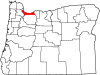
Corbett is an unincorporated community on the Columbia River in eastern Multnomah County, Oregon, United States. It is located on the Historic Columbia River Highway (a.k.a. Crown Point Highway) between the Sandy River and Crown Point.
Corbett was named for prominent pioneer Senator Henry W. Corbett.[2] Senator Corbett purchased a farm in the area in 1885. After several name changes, the post office in the area was named "Corbett" in 1895.
Corbett School District runs the Corbett School and the Corbett Charter School.
Notable people
- Julius Meier, politician
- Billy Oskay, musician
- Patti Smith, politician
- Fritz Springmeier, author
- Dave Stief, football player
References
- ^ a b U.S. Geological Survey Geographic Names Information System: Corbett, Oregon
- ^ McArthur, Lewis A.; McArthur, Lewis L. (2003) [1928]. Oregon Geographic Names (7th ed.). Portland, Oregon: Oregon Historical Society Press. ISBN 978-0875952772.
External links
![]() Media related to Corbett, Oregon at Wikimedia Commons
Media related to Corbett, Oregon at Wikimedia Commons
- Privately owned Corbett community website
- v
- t
- e
Municipalities and communities of Multnomah County, Oregon, United States
County seat: Portland
communities
‡This populated place also has portions in an adjacent county or counties
- Oregon portal
- United States portal
Authority control databases | |
|---|---|
| International |
|
| National |
|
 | This Multnomah County, Oregon state location article is a stub. You can help Wikipedia by expanding it. |
- v
- t
- e


