Canby Mountain
Mountain in the American state of Colorado


Canby Mountain
Location in Colorado
Show map of Colorado
Canby Mountain
Canby Mountain (the United States)
Show map of the United StatesSan Juan Mountains[5]
Canby Mountain is a 13,478-foot-elevation (4,108-meter) mountain summit in San Juan County, Colorado, United States.
Description
Canby Mountain is located six miles (9.7 km) east of the community of Silverton, on land managed by Rio Grande National Forest. Canby Mountain is situated on the Continental Divide in the San Juan Mountains which are a subrange of the Rocky Mountains. Headwaters of the Rio Grande form at the eastern base of the mountain,[6] whereas precipitation runoff from the mountain's west slope drains into tributaries of the Animas River. Topographic relief is modest as the summit rises 1,300 feet (400 meters) in one-half mile (0.8 km). Neighbors include Sheep Mountain, 1.87 miles (3.01 km) to the southeast and Greenhalgh Mountain, 2.49 miles (4.01 km) to the east-southeast.[5] The Continental Divide Trail and Colorado Trail traverse the peak's slopes and an ascent of the summit from historic Stony Pass covers one-half mile of off-trail hiking with 890-feet of elevation gain.[1] The mountain's toponym has been officially adopted by the United States Board on Geographic Names,[4] and was recorded in publications as "Mount Canby" as early as 1877.[7][8]
Climate
According to the Köppen climate classification system, Canby Mountain is located in an alpine subarctic climate zone with cold, snowy winters, and cool to warm summers.[9] Due to its altitude, it receives precipitation all year, as snow in winter and as thunderstorms in summer, with a dry period in late spring.
Gallery
-
 East aspect
 -
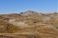
 South aspect of Canby Mountain viewed from Colorado Trail
 -
 North aspect viewed from Maggie Gulch


See also
 Mountains portal
- Thirteener
- Mountains of San Juan County, Colorado
- Edward Canby

References
- ^ a b Robert M. Ormes (2000), Guide to the Colorado Mountains, Colorado Mountain Club Press, ISBN 9780967146607, p. 286.
- ^ The Columbia Gazetteer of the World: A to G (2008), Columbia University Press, p. 636.
- ^ a b c d "Canby Mountain - 13,487' CO". listsofjohn.com. Retrieved May 20, 2023.
- ^ a b "Canby Mountain". Geographic Names Information System. United States Geological Survey, United States Department of the Interior. Retrieved May 20, 2023.
- ^ a b "Canby Mountain, Colorado". Peakbagger.com. Retrieved May 20, 2023.
- ^ Tim Palmer (2021), Field Guide to Rivers of the Rocky Mountains, Falcon Guides, ISBN 9781493052400, p 89.
- ^ Henry Gannett (1877), Lists of Elevations Principally in that Portion of the United States West of the Mississippi River, Fourth Edition, US Government Printing Office, p. 118.
- ^ Henry Gannett, United States Geological Survey (1906), A Gazetteer of Colorado, US Government Printing Office, p. 36.
- ^ Peel, M. C.; Finlayson, B. L.; McMahon, T. A. (2007). "Updated world map of the Köppen−Geiger climate classification". Hydrol. Earth Syst. Sci. 11. ISSN 1027-5606.
External links
- Weather forecast: Canby Mountain
- National Geodetic Survey Data Sheet: Canby
Places adjacent to Canby Mountain | ||||||||||||||||
|---|---|---|---|---|---|---|---|---|---|---|---|---|---|---|---|---|
| ||||||||||||||||


- v
- t
- e

- Mount Garfield
- Aspen Mountain
- Capitol Peak
- Castle Peak
- Cathedral Peak
- Chair Mountain
- Crested Butte
- Gothic Mountain
- Italian Mountain
- Maroon Bells
- Mount Emmons
- Mount Owen
- Mount Sopris
- Pyramid Peak
- Snowmass Mountain
- Snowmass Peak
- Treasure Mountain
- Black Mountain (Moffat County)
- Columbus Mountain
- Elk Mountain (Routt County)
- Hahns Peak
- Flat Top Mountain
- Sleepy Cat Peak
- Eagles Nest
- Jacque Peak
- Meridian Peak
- Mount Powell
- The Spider
- Crater Peak
- North Mamm Peak
- Clark Peak
- Arkansas Hills
- Clinton Peak
- Dyer Mountain
- Gemini Peak
- Horseshoe Mountain
- Mount Arkansas
- Mount Bross
- Mount Buckskin
- Mount Democrat
- Mount Lincoln
- Mount Sheridan
- Mount Sherman
- Pacific Peak
- West Buffalo Peak
- Elk Mountain (Grand County)
- Parkview Mountain
- Radial Mountain
- Whiteley Peak
| Sangre de Cristo Range |
|
|---|---|
| Wet Mountains |
|
| Others |
|
| Collegiate Peaks |
|
|---|---|
| Others |
|
- Crystal Peak
- Fletcher Mountain
- Peak 10
- Peak One
- Quandary Peak
- Tenmile Peak
- Bear Mountain
- Blair Mountain
- Chalk Mountains
- Cochetopa Hills
- Dawson Butte
- Diamond Peak
- Flirtation Peak
- Granite Peak
- Grand Hogback
- Grannys Nipple
- Horsefly Peak
- Lead Mountain (Grand County)
- Mount Neva
- Powell Peak
- San Luis Hills
- Storm King Mountain
- Terrible Mountain
- Two Buttes
- Ute Mountain


