Brignall
Human settlement in England
- Brignall
- County Durham
- County Durham
- North East
- List of places
- UK
- England
- County Durham
Brignall village is located in an elevated position adjacent to the River Greta, about 2 km upstream from Greta Bridge. The village is within the Teesdale district of south-west County Durham, England, the nearest town is the market town of Barnard Castle. The village is best known for the scenic valley section of the River Greta known as Brignall Banks, which is a Site of Special Scientific Interest. [1] [b]
Natural England maps
Maps for Brignall village and the surrounding area, showing Access, Administrative Geographies and other criteria from Natural England: [c]
- MAGiC MaP : Brignall village.[2]
- MAGiC MaP : Confluence of Brignall stream and River Greta.[5] [h] [j]
Governance
The population at the 2011 Census remained less than 100. Details are kept within the parish of Rokeby. It was historically located in the North Riding of Yorkshire but along with the rest of the former Startforth Rural District it was transferred to County Durham for administrative and ceremonial purposes on 1 April 1974, under the provisions of the Local Government Act 1972.
Name
Name history
The name was recorded as Bringhenale in the Domesday Book of 1086 A.D. [q] [r]
British History Online: [11]
- Bringhenale, Bringhale (11th cent.)
- Brigenhall, Brigenhale (12th–13th cent.)
English surnames
Thomas de Briggenhale appeared in the Poll Tax rolls for the County of Yorkshire in 1379. [12]
The following English surnames might be derived from the place name: [12]
- Brignall
- Brignell
- Bricknall
- Bricknell
Toponym

- . . . nook of land [13]
- Bridge by the nook of land between the stream and the river. [u]
Brignall : Brig..en..hale (12th-13th cent.), Brick..n..all (surname);
The name element Brig is from Medieval English brig ( " bridge " ). [v] [w]
The name element Brick is from Old English brycg ( " bridge " ). [x] [y]
The name element ' en ' is a common abbreviation of Medieval English atten ( " at the, by the " ). [z]
The name element hale is from Old English healh ( " corner, nook, secret place, corner of land left by the stream in a river valley " ). [aa] [ab] [ac]
Name examples
Look up healh in Wiktionary, the free dictionary.
Examples of place names that might have a similar etymology :
- Healaugh near Reeth, Swaledale : " Summer pasture by the nook of land between the Barney Beck and the River Swale ".
- Pecknell near Barnard Castle, Teesdale : " . . .nook of land between the Scur Beck and the River Tees ".
- Bracknell, Berkshire : Braccan heal (942 A.D.) , Brakenhale ( Brak..en..hale ) [ad]
History
Domesday book
The village was recorded in the Domesday Book (1086 A.D.) as a settlement in the hundred of land of Count Alan in the county of Yorkshire. [17]
- Households: 16 villagers. 3 freemen. 6 smallholders. 1 men
- Ploughland: 152.5 ploughlands. 6 lord's plough teams. 12.5 men's plough teams.
- Other resources: Meadow 12 acres. Woodland 1 * 1 leagues. 1 fishery. 2 churches.
The list of villages recorded in the local area were described as partially "waste" , possibly due to The Harrying of the North (1069–1070). [ae]
Art and culture
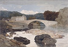
The River Greta and the Brignall area were painted by John Sell Cotman[18] and J. M. W. Turner[19][20][21] amongst others.
Bird watching, walking and other outdoor activities can be pursued in the area.
The area features in Sir Walter Scott’s 1813 poem ‘Rokeby’:
”Oh Brignal banks are wild and fair/ and Greta woods are green”.
References
Notes
- ^ Use Table of Contents for Colour Mapping
- ^ The map shows: [a]
- TOP LEFT – Brignall village
- TOP RIGHT – River Greta and Brignall Banks SSSI
- ^ MAGiC MaP : Use Table of Contents for Colour Mapping
- ^ Mapping criteria : See Table of Contents:
- Administrative Geographies > Parish boundary.
- ^ Mapping criteria : See Table of Contents:
- Designations > Listed Buildings (England).
- ^ Use Table of Contents for Colour Mapping
- ^ The map shows: [f]
- TOP LEFT – St Marys church in the village
- MIDDLE RIGHT – The old church and several listed structures
- ^ Mapping criteria : See Table of Contents:
- Designations > Listed Buildings (England).
- ^ Use Table of Contents for Colour Mapping
- ^ The map shows: [i]
- TOP LEFT – Confluence of Brignall stream and River Greta
- BOTTOM LEFT – The old church and several listed structures
- ^ Mapping criteria : See Table of Contents:
- Sites of Special Scientific Interest (England).
- ^ Mapping criteria : See Table of Contents:
- Designations > Listed Buildings (England).
- Habitats and Species > Woodland.
- ^ Use Table of Contents for Colour Mapping
- ^ The map shows: [m]
- TOP LEFT – Brignall mill
- TOP – Priority Habitat – Deciduous Woodland
- BOTTOM – Ancient and Semi-Natural Woodland
- ^ Mapping criteria : See Table of Contents:
- Designations > Scheduled Monument (England).
- ^ Mapping criteria : See Table of Contents:
- Designations > Scheduled Monument (England).
- ^ Eurvikscire : Page XXIII. See paragraph 4 ( beginning "In Barton . . ." ). [10]
- ^ See also Brignall > History > Domesday book
- ^ Use Table of Contents for Colour Mapping
- ^ The map shows: [s]
- TOP LEFT – Confluence of Brignall Beck and River Greta.
- BOTTOM LEFT – The old church and several listed structures.
- ^ Brignall Beck flows slowly through the village and past the church before descending steeply down to join the River Greta below. Where the stream and river meet there is a nook of land with evidence of cultivation terraces and the ruins of the old St Mary's church.[5] [t]
- ^ WiKtionary : Middle English < brig > " bridge " .
- ^ Examples of ' Brig ' place names:
- Brig o' Turk , ( Trossachs, Scotland ) : " bridge over the River Turk ".
- Brig o' Balgownie , ( Aberdeen, Scotland ) : " bridge of Balgownie ".
- Brighouse, ( West Yorkshire ) : " bridge house ".
- ^ Old English < brycg > f. ( " bridge " ). [14]
- ^ WiKtionary : Old English < brycg > " bridge ".
- ^ Medieval English < atten > ( " at the, by the " ) [15]
- ^ Old English hale equates to Old English healh [16]
- ^ Old English < healh > m. ( " corner, nook, secret place, corner of land left by the stream in a river valley " ) [14]
- ^ WiKtionary : Old English < healh > " corner, angle, recess, nook ".
- ^ An early form of the town's name, Brakenhale, still survives as the name of one of its schools. See The Brakenhale School.
- ^ Waste: Estates described as "waste" paid no tax. About 10% of all the estates in Domesday are waste. Most are in the North or on the Welsh Borders. . .[17]
Citations
- ^ "MAGiC MaP : Brignall village and Brignall Banks". Natural England – Magic in the Cloud.
- ^ "MAGiC MaP : Brignall village". Natural England – Magic in the Cloud.
- ^ "MAGiC MaP : Brignall parish boundary". Natural England – Magic in the Cloud.
- ^ "MAGiC MaP : Brignall village – Listed buildings". Natural England – Magic in the Cloud.
- ^ a b "MAGiC MaP : Confluence of Brignall stream and River Greta". Natural England – Magic in the Cloud.
- ^ "MAGiC MaP : Brignall Banks SSSI". Natural England – Magic in the Cloud.
- ^ "MAGiC MaP : Brignall mill and ancient woodland". Natural England – Magic in the Cloud.
- ^ "MAGiC MaP : Greta Bridge and Roman fort". Natural England – Magic in the Cloud.
- ^ "MAGiC MaP : Confluence of River Greta and River Tees". Natural England – Magic in the Cloud.
- ^ *"Eurvikscire : Page XXIII". Open Domesday. Retrieved 1 November 2022.
- ^ Page 1914, pp. 49–51.
- ^ a b *"Last Name : Brignall". Surname DB. Retrieved 1 November 2022.
- ^ *"Key to English Place-Names: Brignall". University of Nottingham. Retrieved 1 November 2022.
- ^ a b Clark Hall 1916, p. 120.
- ^ Reaney 1969, p. 37.
- ^ Clark Hall 1916, p. 323.
- ^ a b *"BRIGNALL". Open Domesday. Retrieved 1 November 2022.
- ^ Brignall Banks on the Greta – John Sell Cotman, Leeds Art Gallery. Retrieved 10 March 2008.
- ^ The Turner Gallery. A Series of One Hundred and Twenty Engravings Archived 2008-04-11 at the Wayback Machine, Antiquarian Maps and Prints. Retrieved 10 March 2008.
- ^ Brignall Church by J.M.W. Turner Archived 2006-02-15 at the Wayback Machine, Antiquarian Maps and Prints. Retrieved 10 March 2008.
- ^ Yorkshire, Brignall Church, after Turner, 1855, Steve Bartrick Antique Prints and Maps. Retrieved 10 March 2008.
Sources
- Books
- Reaney, P H (1969). The Origin of English Place Names. Routledge & Kegan Paul.
- Clark Hall, John R. (1916). A Concise Anglo−Saxon Dictionary, Second Edition. The Macmillan Company.
- Downloads
- Page, W.H., ed. (1914). 'Parishes: Brignall' ,in A History of the County of York North Riding: Volume 1. Victoria County History. British History Online. pp. 49–51. Retrieved 1 November 2022.
External links
![]() Media related to Brignall at Wikimedia Commons
Media related to Brignall at Wikimedia Commons
- v
- t
- e
- including Stockton-on-Tees (north of the river)
- Parishes
- Archdeacon Newton
- Barmpton
- Bishopton
- Brafferton
- Coatham Mundeville
- Denton
- East and West Newbiggin
- Great Burdon
- Great Stainton
- Heighington
- High Coniscliffe
- Houghton le Side
- Hurworth
- Killerby
- Little Stainton
- Low Coniscliffe and Merrybent
- Middleton St. George
- Morton Palms
- Neasham
- Piercebridge
- Sadberge
- Summerhouse
- Walworth
- Whessoe
- Unparished areas
- The former Darlington County Borough
- Towns
- Barnard Castle
- Bishop Auckland
- Chilton
- Ferryhill
- Great Aycliffe
- Greater Willington
- Peterlee
- Seaham
- Sedgefield
- Shildon
- Spennymoor
- Stanley
- Tow Law
- Parishes
- Barforth
- Barningham
- Bearpark
- Belmont
- Bishop Middleham
- Bolam
- Boldron
- Bournmoor
- Bowes
- Bradbury and the Isle
- Brancepeth
- Brandon and Byshottles
- Brignall
- Burnhope
- Cassop-cum-Quarrington
- Castle Eden
- City of Durham
- Cleatlam
- Cockfield
- Cornforth
- Cornsay
- Cotherstone
- Coxhoe
- Croxdale and Hett
- Dalton-le-Dale
- Dene Valley
- Easington Colliery
- Easington Village
- Edmondbyers
- Edmondsley
- Eggleston
- Egglestone Abbey
- Eldon
- Esh
- Etherley
- Evenwood and Barony
- Fishburn
- Forest and Frith
- Framwellgate Moor
- Gainford
- Gilmonby
- Great Lumley
- Greencroft
- Hamsterley
- Hamsterley Common
- Haswell
- Hawthorn
- Headlam
- Healeyfield
- Hedleyhope
- Hilton
- Holwick
- Hope
- Horden
- Hunderthwaite
- Hunstanworth
- Hutton Henry and Station Town
- Hutton Magna
- Ingleton
- Kelloe
- Kimblesworth and Plawsworth
- Lanchester
- Langleydale and Shotton
- Langton
- Lartington
- Little Lumley
- Lunedale
- Lynesack and Softley
- Marwood
- Mickleton
- Middleton in Teesdale
- Middridge
- Monk Hesleden
- Mordon
- Morton Tinmouth
- Muggleswick
- Murton
- Nesbitt
- Newbiggin
- North Lodge
- Ouston
- Ovington
- Pelton
- Pittington
- Raby with Keverstone
- Rokeby
- Romaldkirk
- Sacriston
- Satley
- Scargill
- Seaton with Slingley
- Shadforth
- Sheraton with Hulam
- Sherburn Village
- Shincliffe
- Shotton
- South Bedburn
- South Hetton
- Staindrop
- Stanhope
- Startforth
- Streatlam and Stainton
- Thornley
- Toft Hill
- Trimdon
- Trimdon Foundry
- Urpeth
- Waldridge
- Wackerfield
- Weather Hill Wood
- West Auckland
- West Rainton and Leamside
- Westwick
- Wheatley Hill
- Whorlton
- Windlestone
- Wingate
- Winston
- Witton Gilbert
- Witton-le-Wear
- Wolsingham
- Wolsingham Park Moor
- Woodland
- Wycliffe with Thorpe
- Unparished areas
- The former Chester le Street Urban District
- Consett
- Parts of the former Durham Municipal Borough
- Parts of the former Bishop Auckland Urban District
- Crook and Willington Urban District
- Stanley Urban District
- Towns
- Headland
- Parishes
- Brierton
- Claxton
- Dalton Piercy
- Elwick
- Greatham
- Hart
- Newton Bewley
- Wynyard
- Unparished areas
- Part of the former Hartlepool County Borough
- Towns
- Billingham
- Parishes
- Aislaby
- Carlton
- Egglescliffe
- Elton
- Grindon and Thorpe Thewles
- Longnewton
- Newsham
- Preston-on-Tees
- Redmarshall
- Stillington and Whitton
- Wolviston
- Wynyard
- Unparished areas
- Part of the former Teesside County Borough
- For further information about the above parishes, see List of civil parishes in County Durham.
- For the part of Stockton-on-Tees (borough) south of the River Tees, see List of civil parishes in North Yorkshire.


