Bamba, Gao Region
Commune and town in Gao Region, Mali
17°02′N 1°24′W / 17.033°N 1.400°W / 17.033; -1.400 Mali
Mali (2009 Census)[2]
Bamba is a small town and rural commune in the Bourem Cercle of the Gao Region of Mali. The town is located on the left (north) bank of the Niger River, 190 km east of Timbuktu and 230 km northwest of the town of Gao. In the 2009 census the commune had a population of 28,524.
The commune of Bamba includes 19 villages and 7 nomadic population groups. The population are primarily Songhais but also Tuaregs and Bozos.
Ted Joans wrote a poem to "Le fou de Bamba" (The madman of Bamba).
On 6 April 2020, at least 20 soldiers were killed in an attack on a military base.[3]
On 1 October 2023, Tuareg rebels seized control of the town.[4]
References
- ^ Schéma Directeur de Lutte Contre l’Ensablement dans le Nord du Mali (6ème et 7ème Régions): Monographie de la Commune de Bamba (PDF) (in French), Ministère de l’Environnement et de l’Assainissement, République du Mali, 2004, archived from the original (PDF) on 2011-07-22
- ^ Resultats Provisoires RGPH 2009 (Région de Gao) (PDF) (in French), République de Mali: Institut National de la Statistique, archived from the original (PDF) on 2011-07-22.
- ^ "Mali: un camp militaire attaqué par des jihadistes dans la région de Gao". RFI (in French). 2020-04-06. Retrieved 2023-10-06.
- ^ "Mali crisis: Fierce fighting erupts after Tuareg rebels kill 'more than 80 soldiers'". BBC News. 2023-10-01. Retrieved 2023-10-01.
External links
- Plan de Sécurité Alimentaire Commune de Bamba 2005-2009 (PDF) (in French), Commissariat à la Sécurité Alimentaire, République du Mali, USAID-Mali, 2006, archived from the original (PDF) on 2012-04-29.
- v
- t
- e
| ||
|---|---|---|
Capital: Gao | ||
| Ansongo Cercle | 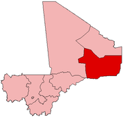 | |
| Bourem Cercle | ||
| Gao Cercle | ||


