Balsha Island
62°28′24″S 60°11′35″W / 62.47333°S 60.19306°W / -62.47333; -60.19306
South Shetland Islands
[1]
Balsha Island (Bulgarian: остров Балша, romanized: ostrov Balsha, IPA: [ˈɔstrov ˈbaɫʃɐ]) is an ice-free island in the Dunbar group off the northwest coast of Varna Peninsula, Livingston Island in the South Shetland Islands, Antarctica. It is situated 1.5 km (0.93 mi) northwest of Slab Point and 2.8 km (1.7 mi) north of Kotis Point. Extending 600 by 300 m (660 by 330 yd), surface area 17 hectares (42 acres).[1] The area was visited by early 19th century sealers.
The island is named after the settlement of Balsha in western Bulgaria.
Location
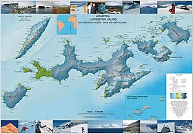
Balsha Island is located at 62°28′24″S 60°11′35″W / 62.47333°S 60.19306°W / -62.47333; -60.19306. Bulgarian topographic survey by Tangra 2004/05 expedition. British mapping in 1968, Chilean in 1971, Argentine in 1980, Bulgarian in 2005 and 2009.
See also
- Composite Gazetteer of Antarctica.
- List of Antarctic islands south of 60° S
- SCAR
- Territorial claims in Antarctica
References
- ^ a b L.L. Ivanov. Antarctica: Livingston Island and Greenwich, Robert, Snow and Smith Islands. Archived April 24, 2008, at the Wayback Machine Scale 1:120000 topographic map. Troyan: Manfred Wörner Foundation, 2009. ISBN 978-954-92032-6-4
External links
- Balsha Island. SCAR Composite Gazetteer of Antarctica.
- Bulgarian Antarctic Gazetteer. Antarctic Place-names Commission. (details in Bulgarian, basic data in English)
External links
- Balsha Island. Copernix satellite image
This article includes information from the Antarctic Place-names Commission of Bulgaria which is used with permission.
Portals:
 Islands
 Geography


- v
- t
- e
- Clarence
- Deception
- Elephant
- Greenwich
- King George
- Livingston
- Low
- Nelson
- Robert
- Smith
- Snow
- Afala
- Aitcho
- Akin
- Alfeus
- Araguez
- Astor
- Aurelia
- Barlow
- Basso
- Beslen
- Biruni
- Boatin
- Borceguí
- Bridgeman
- Cacho
- Chiprovtsi
- Cornwall
- Cornwallis
- Craggy
- Dee
- Desolation Island (South Shetland Islands)
- Dinea
- Dioptra
- Dufayel
- Dunbar
- Eadie
- Express
- Fregata
- Gergini
- Gibbs
- Glumche
- Gnomon
- González
- Half Moon
- Heywood
- Kabile
- Kaliman
- Kondor
- Korsis
- Låvebrua
- Meade
- Miladinovi
- Montufar
- Ogygia
- Ongley
- Onogur
- Penguin
- Pindarev
- Pordim
- Presnakov
- Prisad
- Prosechen
- Pyramid
- Rogozen
- Romeo
- Rotalia
- Rowett
- Rugged
- Saffar
- San Telmo
- Seal
- Sierra
- Square End
- Stoker
- Sugarloaf
- Table
- Tatul
- Tirizis
- Toledo
- Treklyano
- Two Summit
- Valchedram
- Window
- Withem
- Wood
- Yrvind
- Zebil
- Zed
Rocks, stacks, reefs
spits and banks
spits and banks
- Aim Rocks
- Alepu
- Avren
- Baktriana
- Ballestilla
- Bekas
- Belchin
- Besson
- Bizone
- Bonert
- Borda
- Bowler
- Brahe
- Bris
- Buchino
- Caraquet
- Chabrier
- Channel
- Chaos
- Chapman
- Cheshire
- Chorobates
- Cone
- Cosmolabe
- Cove
- Cutler
- Dlagnya
- Dovizio
- Dzhegov
- Eddystone
- Elemag
- Eliza
- Emm
- Enchantress
- Folger
- Frederick
- Galiche
- Goritsa
- Grace
- Graovo
- Groma
- Growler
- Habermehl
- Hauken
- Henfield
- Hetty
- Hole
- Holmes
- Ibar
- Indian
- Keep
- Kianida
- Knight
- Koynare
- Lenoir
- Letelier
- Liberty
- Lientur
- Limit
- Livonia
- Long
- Low
- Lynx
- Lyutibrod
- Maglizh
- Makresh
- Martello Tower
- Meldia
- Mellona
- Milev
- Mónica
- Morris
- Nancy
- Napier
- Nessie
- Nikudin
- Odometer
- Okol
- Opaka
- Ørnen
- Orsini
- Orsoya
- Parry Patch
- Passage
- Patresh
- Perivol
- Pig
- Pingvin
- Potmess
- Asses Ears
- Priboy
- Rabisha
- Ramsden
- Raquelia
- Reyes
- Ritchie
- Rongel
- Rosales
- Rusokastro
- Sail Rock
- Salient
- Sally
- Sewing-Machine Needles
- Shearer
- Simms
- Simpson
- Sinbad
- Skrino
- Stackpole
- Stewart
- Suhache
- Syrezol
- Telefon
- Telish
- Tenorio
- The Pointers
- Tooth
- Triznatsi
- Troughton
- Tu
- Turmoil
- Tvarditsa
- Twin Pinnacles
- Upton
- Vardim
- Vergilov
- Vidal
- Vietor
- Vodoley
- Voluyak
- Waldseemüller
- Weeks
Undersea and
subglacial features
subglacial features
| ||||||||
|---|---|---|---|---|---|---|---|---|
| Geography |
|  | ||||||
| History | ||||||||
| Politics | ||||||||
| Society | ||||||||
| Famous explorers | ||||||||
| ||||||||

 | This Livingston Island location article is a stub. You can help Wikipedia by expanding it. |
- v
- t
- e


