Liste der Einträge im National Register of Historic Places im Wapello County

Die Liste der Registered Historic Places im Wapello County in Iowa führt alle 29 Bauwerke und historischen Stätten im Wapello County auf, die in das National Register of Historic Places aufgenommen wurden.[1]
Legende
| NRHP | Historic Place |
|---|---|
| HD | Historic District |
Aktuelle Einträge
| [2] | Name[3] | Bild | Eintragsdatum | Lage | Ort | Beschreibung |
|---|---|---|---|---|---|---|
| 1 | Administration Building, U.S. Naval Air Station Ottumwa |  | 2013 ID-Nr. 13000273 | Terminal Avenue 41.106337-92.440808 | nördlich von Ottumwa | |
| 2 | B'nai Jacob Synagogue |  | 2004 ID-Nr. 04000815 | 529 East Main Street 41° 0′ 57″ N, 92° 24′ 25″ W41.015833-92.406944 | Ottumwa | |
| 3 | Benson Block |  | 1985 ID-Nr. 85000009 | 109-112 North Market Street 41° 1′ 3″ N, 92° 24′ 35″ W41.0175-92.409722 | Ottumwa | |
| 4 | Benson Building | 1995 ID-Nr. 95000969 | 214 East 2nd Street 41° 1′ 1″ N, 92° 24′ 37″ W41.016944-92.410278 | Ottumwa | ||
| 5 | Big 4 Fair Art Hall |  | 1995 ID-Nr. 95000621 | Water Street an den Wapello County Regional Fairgrounds 40° 54′ 31″ N, 92° 12′ 53″ W40.908611-92.214722 | Eldon | |
| 6 | Burlington Depot | 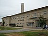 | 2008 ID-Nr. 08001100 | 210 West Main Street 41° 1′ 8,7″ N, 92° 24′ 51,6″ W41.01909-92.41432 | Ottumwa | |
| 7 | Chief Wapello's Memorial Park | 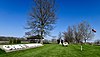 | 1975 ID-Nr. 75000700 | Abseits des US 34 40° 59′ 31″ N, 92° 17′ 32″ W40.991944-92.292222 | Agency | |
| 8 | Court Hill Historic District | 1998 ID-Nr. 97001605 | 111 East Court Street und 407-1004 North Court Street 41° 1′ 31″ N, 92° 24′ 31″ W41.025278-92.408611 | Ottumwa | ||
| 9 | Dahlonega School No. 1 |  | 2000 ID-Nr. 00000934 | County Road H25 41° 3′ 30″ N, 92° 22′ 13″ W41.058333-92.370278 | nordöstlich von Ottumwa | |
| 10 | Dibble House |  | 1974 ID-Nr. 74002291 | Burton Street Ecke Gothic Street 40° 55′ 18″ N, 92° 12′ 48″ W40.921667-92.213333 | Eldon | |
| 11 | Eldon Carnegie Public Library | 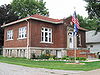 | 1996 ID-Nr. 96000604 | 608 West Elm Street 40° 55′ 12″ N, 92° 13′ 32″ W40.92-92.225556 | Eldon | |
| 12 | Fifth Street Bluff Historic District |  | 1998 ID-Nr. 97001606 | Abgegrenzt durch Jefferson Street, East 6th Street, Washington Street und 4th Street 41° 1′ 9″ N, 92° 24′ 26″ W41.019167-92.407222 | Ottumwa | |
| 13 | First National Bank |  | 1995 ID-Nr. 95000970 | 131 East Main Street 41° 1′ 2″ N, 92° 24′ 42″ W41.017222-92.411667 | Ottumwa | |
| 14 | Foster/Bell House | 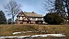 | 1983 ID-Nr. 83000407 | 205 East 5th Street 41° 1′ 11″ N, 92° 24′ 27″ W41.019722-92.4075 | Ottumwa | |
| 15 | J.W. Garner Building |  | 2010 ID-Nr. 10000003 | 222-224 East 2nd Street 41° 1′ 3″ N, 92° 24′ 38″ W41.0175-92.410556 | Ottumwa | |
| 16 | Historic Railroad District |  | 2011 ID-Nr. 11000723 | Abgegrenzt durch Main Street, Washington Street, die Gleise der BNSF Railway und Marion Street 41° 1′ 8″ N, 92° 24′ 53″ W41.018889-92.414722 | Ottumwa | |
| 17 | Hotel Ottumwa | 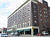 | 2012 ID-Nr. 12000815 | 107 East 2nd Street 41° 1′ 6,9″ N, 92° 24′ 42,5″ W41.018595-92.411812 | Ottumwa | |
| 18 | Jay Funeral Home |  | 1995 ID-Nr. 95000971 | 220 North Court Street 41° 1′ 12″ N, 92° 24′ 35″ W41.02-92.409722 | Ottumwa | |
| 19 | Jefferson Street Viaduct | 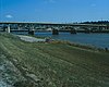 | 1998 ID-Nr. 98000475 | Brücke der Jefferson Street über den Des Moines River 41° 0′ 39″ N, 92° 24′ 55″ W41.010833-92.415278 | Ottumwa | |
| 20 | Mars Hill | 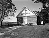 | 1974 ID-Nr. 74000814 | 100th Avenue 40° 53′ 58″ N, 92° 21′ 26″ W40.899444-92.357222 | südöstlich von Ottumwa | |
| 21 | McHaffey Opera House | 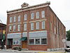 | 1995 ID-Nr. 95001317 | 414 Elm Street 40° 55′ 4″ N, 92° 13′ 22″ W40.917778-92.222778 | Eldon | |
| 22 | North Fellows Historic District |  | 2010 ID-Nr. 10001087 | 1200 North Fellows Street und 1204-1212 North Elm Street 41° 1′ 37″ N, 92° 23′ 49″ W41.026944-92.396944 | Ottumwa | |
| 23 | Ottumwa Cemetery Historic District |  | 1995 ID-Nr. 95000968 | 1302 North Court Street 41° 1′ 59″ N, 92° 24′ 31″ W41.033056-92.408611 | Ottumwa | |
| 24 | Ottumwa Public Library | 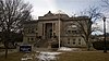 | 1984 ID-Nr. 84001605 | 129 North Court Street 41° 1′ 11″ N, 92° 25′ 21″ W41.019722-92.4225 | Ottumwa | |
| 25 | Ottumwa Young Women's Christian Association | 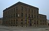 | 2005 ID-Nr. 05000907 | 133 West 2nd Street 41° 1′ 17″ N, 92° 24′ 46″ W41.021389-92.412778 | Ottumwa | |
| 26 | St. Mary's of the Visitation Church and Rectory | 1999 ID-Nr. 99000314 | 103 East 4th Street 41° 1′ 10″ N, 92° 24′ 38″ W41.019444-92.410556 | Ottumwa | ||
| 27 | U.S. Post Office | 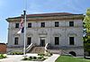 | 1976 ID-Nr. 76000810 | Court Street Ecke 4th Street 41° 1′ 7″ N, 92° 24′ 38″ W41.018611-92.410556 | Ottumwa | |
| 28 | Vogel Place Historic District | 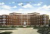 | 1995 ID-Nr. 95000967 | Abgegrenzt durch Ottumwa Country Club, Court Street, den Ottumwa Cemetery und das frühere St. Joseph Hospital 41° 2′ 15″ N, 92° 24′ 10″ W41.0375-92.402778 | Ottumwa | |
| 29 | Wapello County Courthouse | 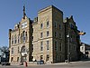 | 1981 ID-Nr. 81000272 | Court Street 41° 1′ 11″ N, 92° 24′ 38″ W41.019722-92.410556 | Ottumwa |
Siehe auch
Einzelnachweise
- ↑ Auszug aus dem National Register of Historic Places - Wapello County Abgerufen am 25. Februar 2012
- ↑ Die Nummerierung in dieser Listenspalte ist an der vom National Park Service vorgelegten Reihenfolge der Einträge orientiert; die Farben unterscheiden verschiedene Schutzgebietstypen des Nationalparksystems mit landesweiter Bedeutung (z. B. National Historic Landmarks) von den sonstigen Einträgen im National Register of Historic Places.
- ↑ National Register Information System. In: National Register of Historic Places. National Park Service, abgerufen am 9. Juli 2010 (englisch).

Einträge im National Register of Historic Places in Iowa
National Register of Historic Places in Iowa
Adair | Adams | Allamakee | Appanoose | Audubon | Benton | Black Hawk | Boone | Bremer | Buchanan | Buena Vista | Butler | Calhoun | Carroll | Cass | Cedar | Cerro Gordo | Cherokee | Chickasaw | Clarke | Clay | Clayton | Clinton | Crawford | Dallas | Davis | Decatur | Delaware | Des Moines | Dickinson | Dubuque | Emmet | Fayette | Floyd | Franklin | Fremont | Greene | Grundy | Guthrie | Hamilton | Hancock | Hardin | Harrison | Henry | Howard | Humboldt | Ida | Iowa | Jackson | Jasper | Jefferson | Johnson | Jones | Keokuk | Kossuth | Lee | Linn | Louisa | Lucas | Lyon | Madison | Mahaska | Marion | Marshall | Mills | Mitchell | Monona | Monroe | Montgomery | Muscatine | O’Brien | Osceola | Page | Palo Alto | Plymouth | Pocahontas | Polk | Pottawattamie | Poweshiek | Ringgold | Sac | Scott | Shelby | Sioux | Story | Tama | Taylor | Union | Van Buren | Wapello | Warren | Washington | Wayne | Webster | Winnebago | Winneshiek | Woodbury | Worth | Wright


